October / November 2011
Back to Project Contents and Introduction
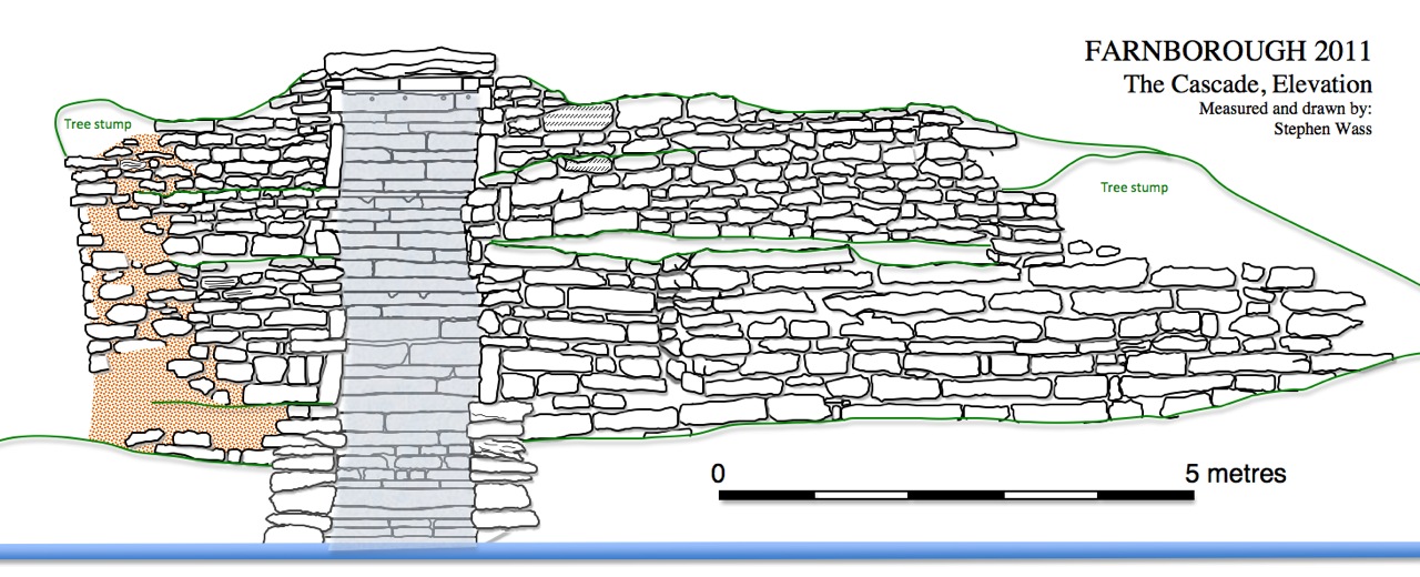
As
well as completing the elevation drawings of the cascade we were also
given the go-ahead to undertake some small scale excavations on the
site of the summerhouse under the following terms :
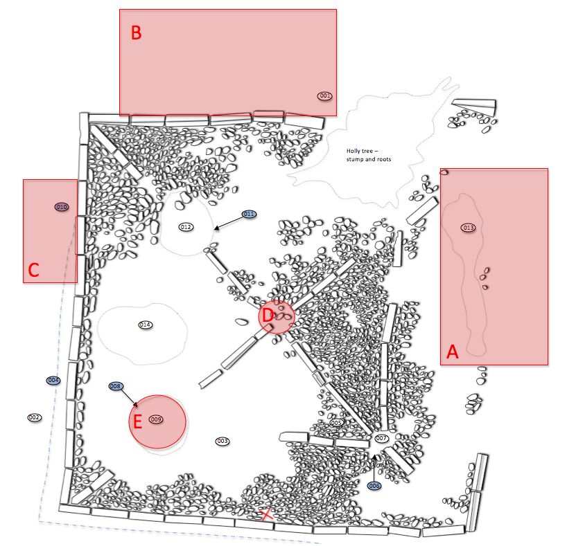
| Rationale for Excavation | Proposed Method |
| The summerhouse is approached via a path down from the hall on its north-east side. We would like to investigate the junction between that path and the entrance to the summerhouse to characterise the nature of the path and discover if there were any special arrangements to mark the entry | We would expect to remove up to 10 cm of leaf mould and compacted topsoil to uncover the uppermost surface of the path. |
| We have no information about the setting of the summerhouse, was it bordered by a path. A fence or planting of some kind? Evidence about this may be recoverable from the level ground immediately adjacent to the north-west | We would expect to remove up to 5 cm of leaf mould and compacted topsoil to investigate the area looking for laid surfaces or stake holes or planting pits |
| The summerhouse appears to be set on a terrace cut in to the rounded top of the mound into which the cascade is set. The original excavation seems to have slightly overcut the trench’s edge so the relationship with the mound and any post-destruction deposition has been lost. However, there is a small area where it appears that we may be able to recover something of the relationship between the earlier mound and the summerhouse | We would carefully clean existing exposed surfaces and then remove any layers which represent build post-demolition and then examine the cut made for the terracing |
| There appears to be a sunken feature at the very centre of the summerhouse floor into which at least three of the edging stones have sunk. We would like to investigate this feature in order to determine if it represents some central feature such as a roof post or a setting for a central table | After defining the area by surface cleaning and the removal of some displaced cobbles we would excavate half of any revealed feature in order to determine its profile and the composition of the fill. |
| We have one surviving setting for the eastern corner post. The position of the presumed southern corner post is in an area from which the cobbling has been removed. Surface indications suggest the presence of a large post hole and the possibility that the posts were erected first and the floor surfaces laid up to them. Discovering the whether the post was square or rounded in section would help us towards a better understanding of the complete structure | After defining the area by surface cleaning and the removal of some displaced cobbles we would excavate half of any revealed feature in order to determine its profile and the composition of the fill. |
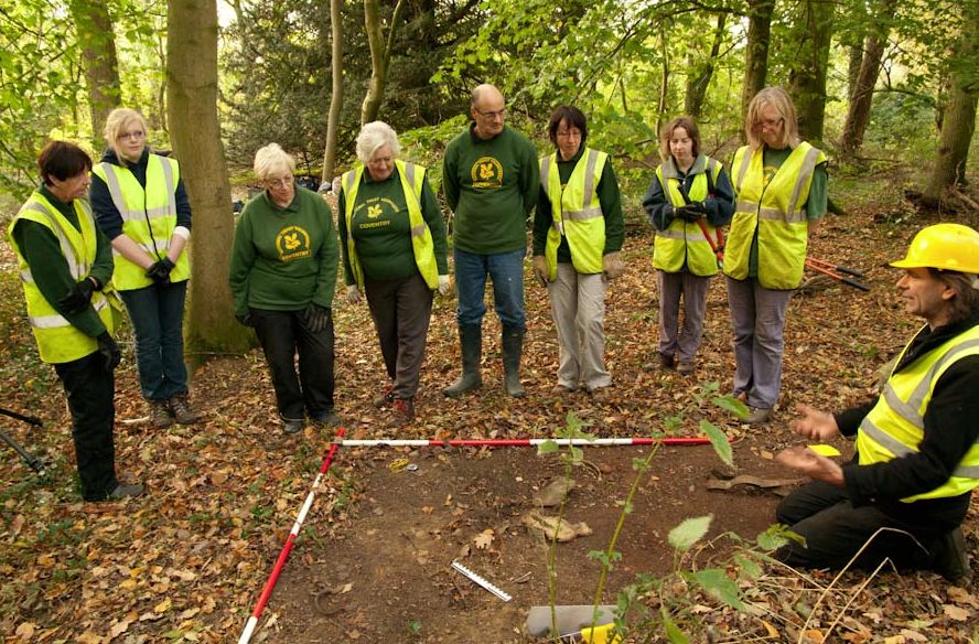
Work
began on Monday October 24th and occupied three full days with a team
of volunteers which included Chris Miller, Geoff Parratt, Peter
Braybrook, Eraine Bosland, Brenda Day and Joe and Verna Wass - a bit of a family effort
here, and was completed on areas A,B, D and E with area C being on hold
at the moment. Our first task was to brush away the considerable amount
of material that had dropped from the surrounding trees over the past
month.
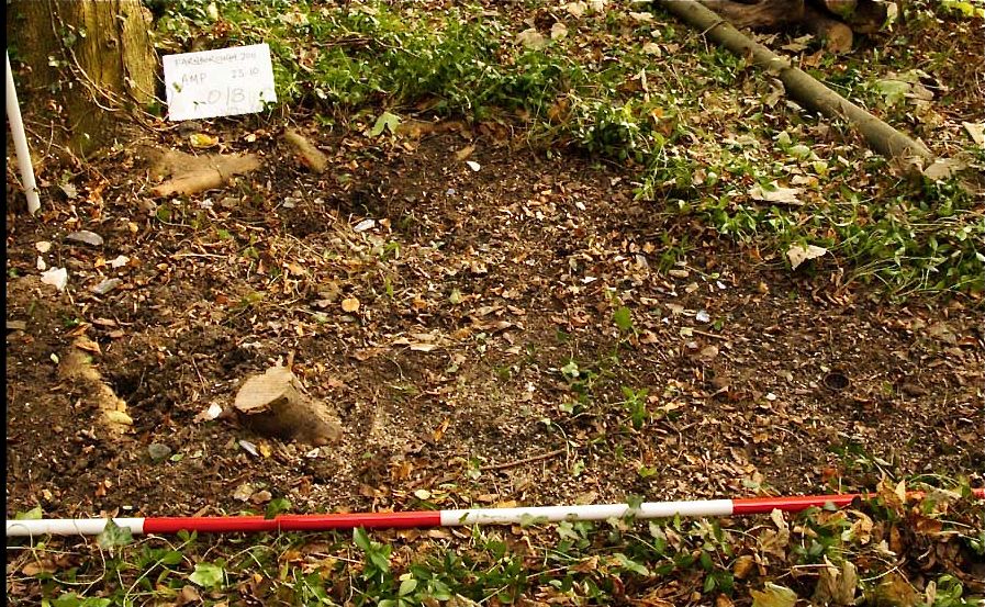
Area A.
The topsoil came off fairly easily here and bottomed on to a very loose fine gravel surface confirming the presence of a path down from the hall to the east. The gravel was little compacted and presented an irregular surface as one might expect from the considerable disturbance by tree roots. The gravel extended the full width of the trench and the path may well therefore have matched the width of the summerhouse at its closest approach. Most of the cobbling and all of the edging slabs had been robbed from area A revealing the fact that the edging stones were not securely set in the underlying make up and seem to have been largely held in place by the surrounding deposits. This may well explain why so many of the outer edging slabs have tipped outwards. There was no evidence of any other special arrangements marking the entrance to the summerhouse such as a porch or threshold.
Work starts on Area A, view from west
Area B
The attempt to investigate conditions outside the summerhouse to the north revealed no evidence for a peripheral path or fencing or any special planting arrangements. The topsoil merged with the cloddy yellowish clayey makeup which we interpreted as dumped material used to create the artificial mound which supported the cascade. Apart from a few small fragments of brick or tile there were no finds which in many ways was surprising. We were hoping for some debris which would have provided evidence for any use of the site but we found none which suggests either that the summerhouse was used primarily as a sheltered view point rather than as a social space in which refreshments may have been consumed. Alternatively they were either very careful about breaking things or very thorough about tidying up afterwards.
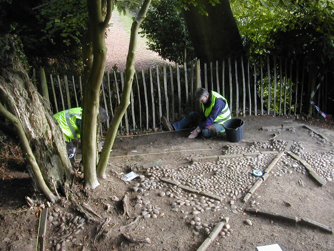
Area D
It was evident from surface indications that the centre point of the summerhouse was slightly sunken. Some loose pebbles and topsoil were removed to reveal cobbling across this central area. Although there was no setting for a central post as had been originally suspected clearly something weighty had pressed down here. Most notable was the fact that one of the lining slabs was badly broken and that its upper surface appeared unusually worn. Had there been a central post resting on the surface or had there been a separate item such a central built in table, perhaps resting on a substantial section of tree trunk in keeping with what we are assuming was its rather rustic appearance.
The attempt to investigate conditions outside the summerhouse to the north revealed no evidence for a peripheral path or fencing or any special planting arrangements. The topsoil merged with the cloddy yellowish clayey makeup which we interpreted as dumped material used to create the artificial mound which supported the cascade. Apart from a few small fragments of brick or tile there were no finds which in many ways was surprising. We were hoping for some debris which would have provided evidence for any use of the site but we found none which suggests either that the summerhouse was used primarily as a sheltered view point rather than as a social space in which refreshments may have been consumed. Alternatively they were either very careful about breaking things or very thorough about tidying up afterwards.
Area D
It was evident from surface indications that the centre point of the summerhouse was slightly sunken. Some loose pebbles and topsoil were removed to reveal cobbling across this central area. Although there was no setting for a central post as had been originally suspected clearly something weighty had pressed down here. Most notable was the fact that one of the lining slabs was badly broken and that its upper surface appeared unusually worn. Had there been a central post resting on the surface or had there been a separate item such a central built in table, perhaps resting on a substantial section of tree trunk in keeping with what we are assuming was its rather rustic appearance.
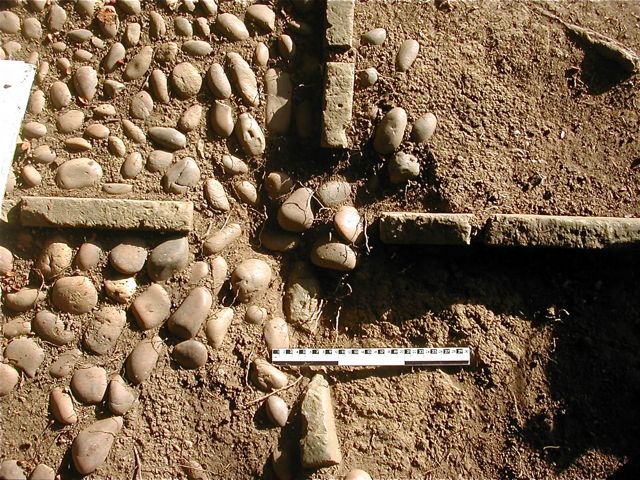
The central area under excavation
Area E
It was evident both from the overall plan and a circular patch of discoloured earth that we were likely to find a setting for a post on the southern corner of the inner stone lining. This took some careful excavation and for the first couple of days we painstakingly cleared a shallow scoop filled with a dark loamy earth with some large fragments of plaster. Below this we broke through into a void which represented the position of an original post and preserved towards the bottom several pieces of decayed wood remained from the post. It was clear from the profile that this was rounded in section and shaped to a point so that it appears that the placement for the post was roughly cleared and a hollow defined in the general area then the post itself was driven in to the ground. Upon demolition it may have been sawn off or left to rot in place until it broke off at ground level. The presence of plaster is a little puzzling. We envisaged the structure as open sided and whilst it is possible that there could have been plastered screen walls or even a ceiling we might have expected to find remains widely distributed across the site despite the fact it was cleared in the 1990s.
It was evident both from the overall plan and a circular patch of discoloured earth that we were likely to find a setting for a post on the southern corner of the inner stone lining. This took some careful excavation and for the first couple of days we painstakingly cleared a shallow scoop filled with a dark loamy earth with some large fragments of plaster. Below this we broke through into a void which represented the position of an original post and preserved towards the bottom several pieces of decayed wood remained from the post. It was clear from the profile that this was rounded in section and shaped to a point so that it appears that the placement for the post was roughly cleared and a hollow defined in the general area then the post itself was driven in to the ground. Upon demolition it may have been sawn off or left to rot in place until it broke off at ground level. The presence of plaster is a little puzzling. We envisaged the structure as open sided and whilst it is possible that there could have been plastered screen walls or even a ceiling we might have expected to find remains widely distributed across the site despite the fact it was cleared in the 1990s.
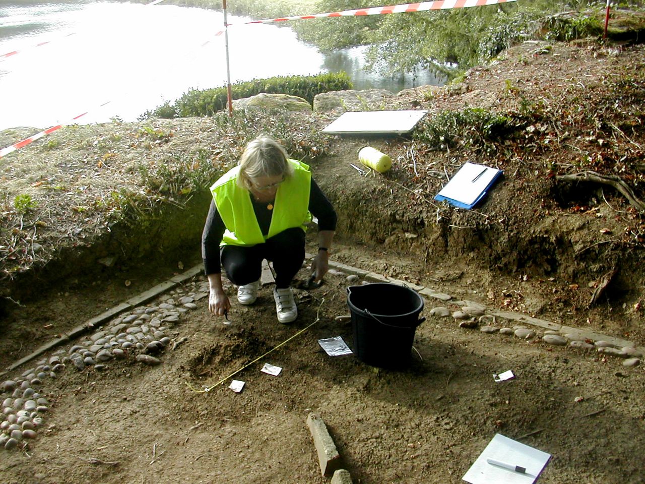
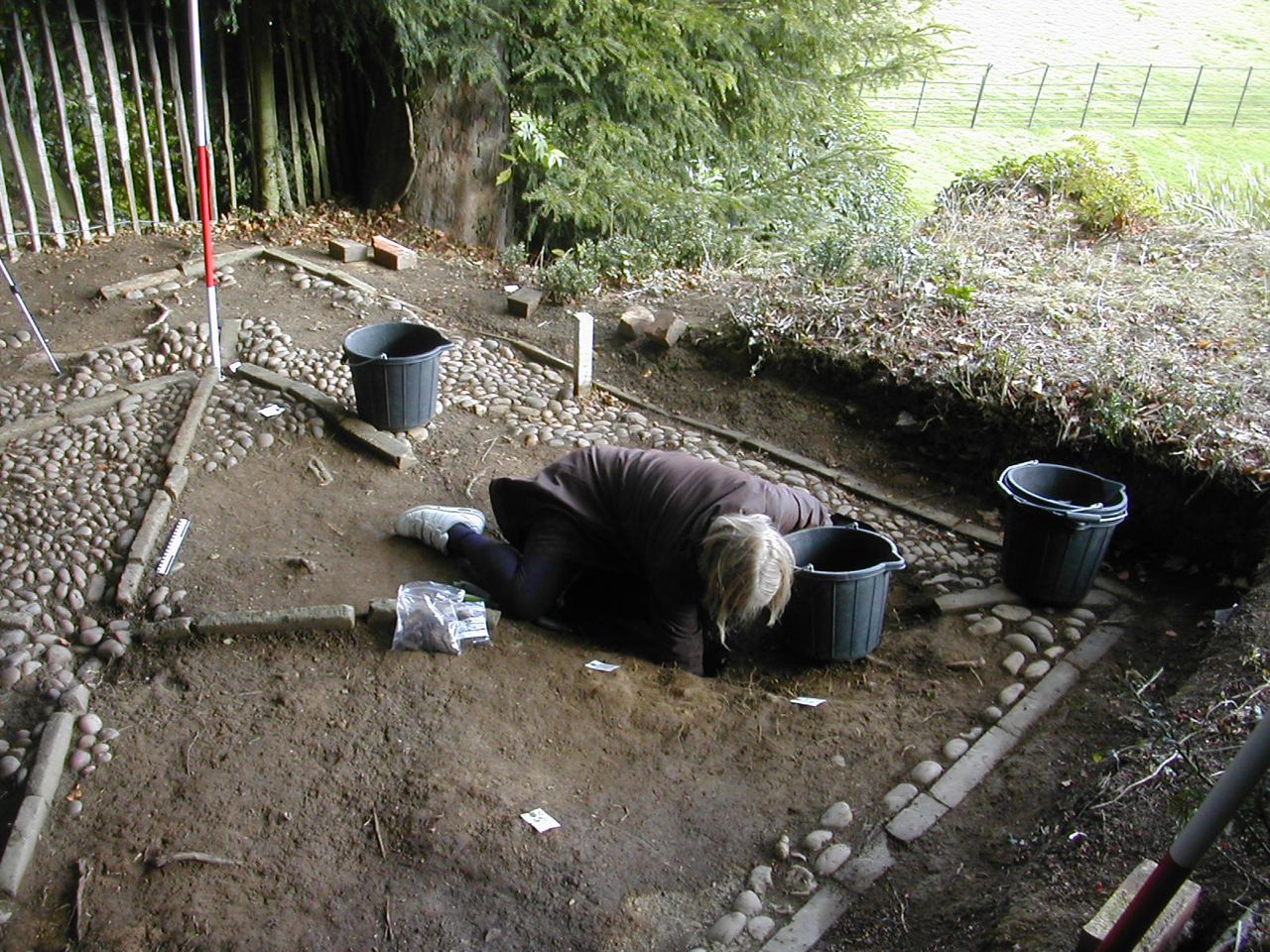
Work begins to define the fill of the post hole and the last fragments of timber are carefully removed for sampling.
There is still work to be done largely recording of some of the deposits uncovered, we operate a system where each identifiable element of the site is treated as a separate context and so gets its very own record sheet, fifteen done so far and counting. We are still very short on dating evidence - a single small piece of decorated slip wear probably eighteenth century was recorded from the topsoil but otherwise all we can say is that it is not shown in the 1771 estate map but does appear in the 1886 Ordnance Survey map, however, by the time we get to 1923 it is no longer shown so could well have been another casualty of the Great War. Now we have identified the position and form of the corner post we can least begin to play around with idea of a reconstruction. the image below is produced with Google SketchUp and represents an attempt to visualise the complete structure. As there was no evidence for a slate or tile roof it was likely to have been thatched or covered in wooden shingles as pictured here. I'll need to play around with the pitch of the roof but have assumed the eaves extended to cover the outer square of lining stones. There are a number of parallels for the built in central table not least up at the oval temple on the terrace although this remains rather conjectural. I'll do some more work on this and hopefully be in a position to model some of the terrain around it at some point. In addition Peter Braybrook a local water colour artist has done some preparatory sketches with a view to producing a more expressive reconstruction of the appearance looking up from the meadow beyond the cascade.
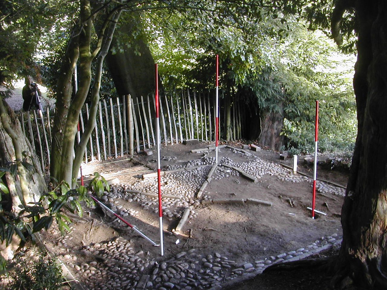
The summerhouse from the west with four ranging rods marking the position of the corner posts. The excavated post hole is nearly 50 cm deep.
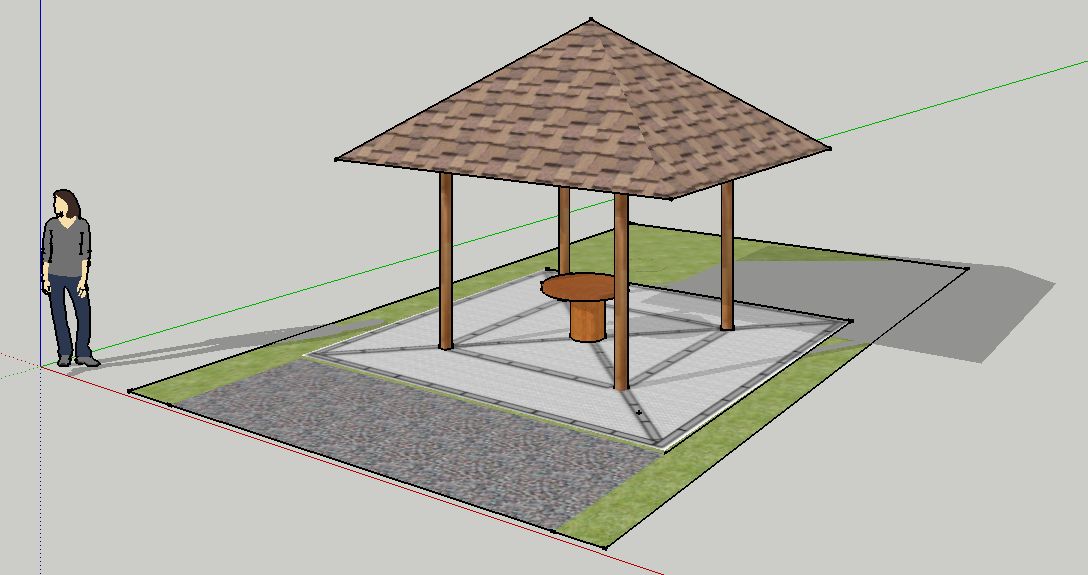
The Summerhouse - restored view from the north.
YOU CAN READ THE FULL REPORT HERE
Also completed after a lot of time fiddling around with measurements is the elevation view of the cascade. Some of this is a little speculative as I tried to do the absolute minimum in clearing vegetation, partly from a conservation point of view but mainly because in some places the vegetation was the only thing holding it all together!
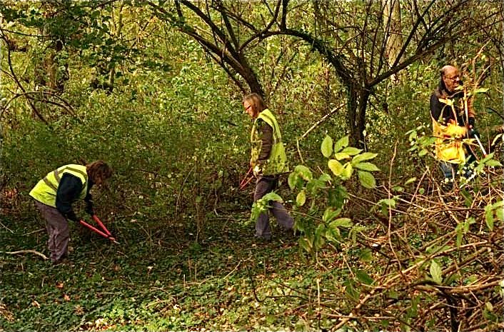
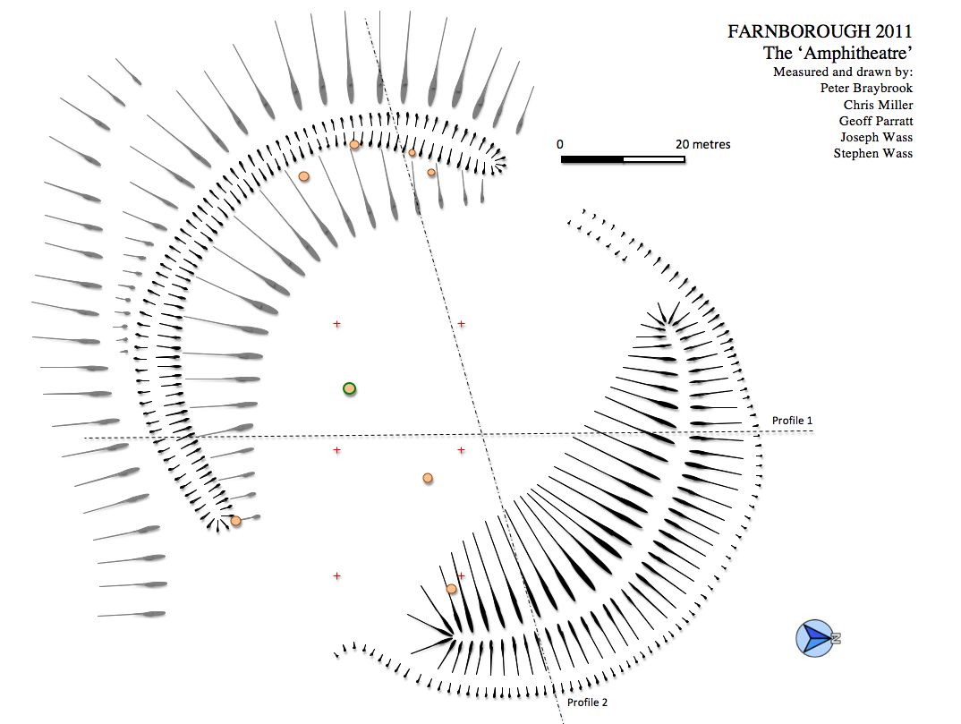
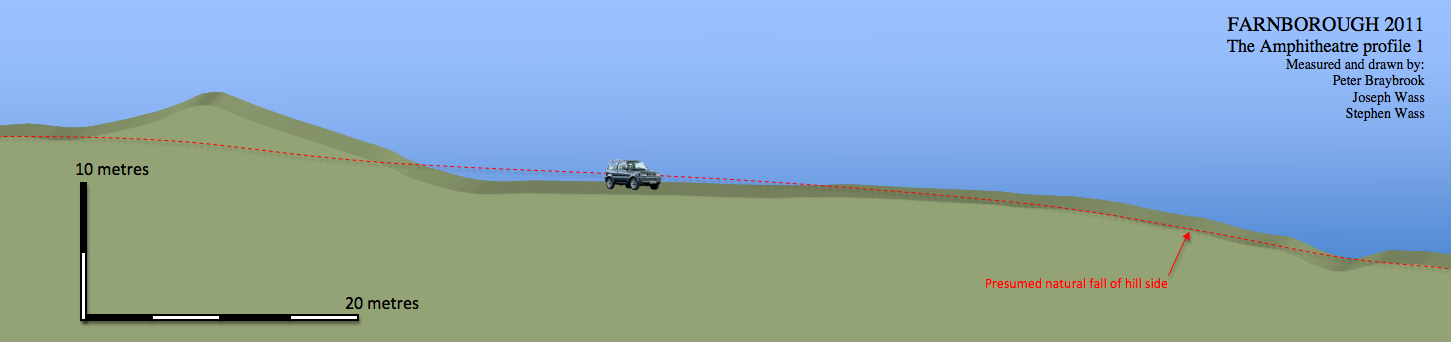
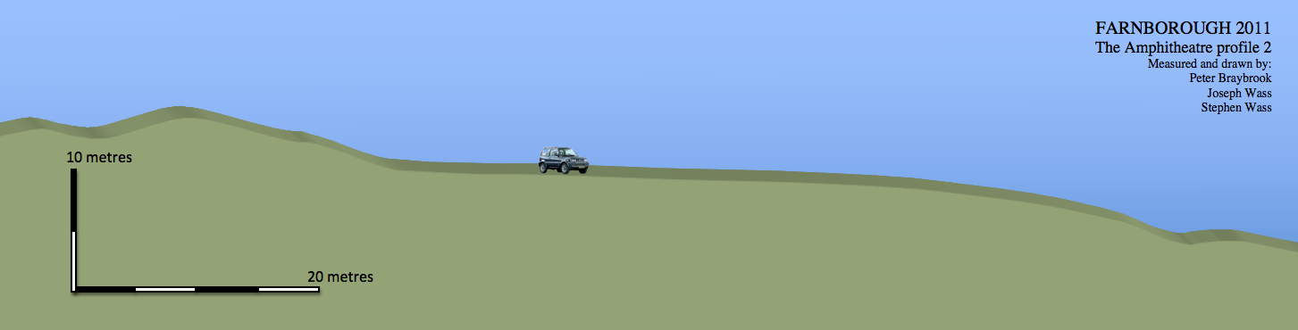
The Amphitheatre.
On Sunday October 23rd. a group of experienced volunteers from Coventry arrived to help clear the undergrowth and fallen trees from the 'amphitheatre. The results were amazing in terms of opening up the view and enabling one to appreciate the size and layout of the monument for the first time. They were briefed to help us identify any surface finds and three areas of interest were defined and recorded with the help of photographer Chris Mitchell (You can read his blog about the day here.) These were a central burned area where presumably bonfires had been lit which included a selection of rusted iron work much of which seemed to have come from a small bath or large bucket of some kind, the possible footings for a length of dry stone wall and a dump of nineteenth century pottery abandoned in the south-west portion of the lower ditch. Again more recording to be done here and we can at last set about making a really accurate plan of the earthworks. many, many thanks to the Coventry team and to Richard and Martin for giving up their Sunday to supervise the whole thing.
On Sunday October 23rd. a group of experienced volunteers from Coventry arrived to help clear the undergrowth and fallen trees from the 'amphitheatre. The results were amazing in terms of opening up the view and enabling one to appreciate the size and layout of the monument for the first time. They were briefed to help us identify any surface finds and three areas of interest were defined and recorded with the help of photographer Chris Mitchell (You can read his blog about the day here.) These were a central burned area where presumably bonfires had been lit which included a selection of rusted iron work much of which seemed to have come from a small bath or large bucket of some kind, the possible footings for a length of dry stone wall and a dump of nineteenth century pottery abandoned in the south-west portion of the lower ditch. Again more recording to be done here and we can at last set about making a really accurate plan of the earthworks. many, many thanks to the Coventry team and to Richard and Martin for giving up their Sunday to supervise the whole thing.
Trying to look as if we know what's going on. The dump of pottery. Clearing continues.
View looking north across the central cleared area towards the massive bank.
(Photos by Chris Mitchell)
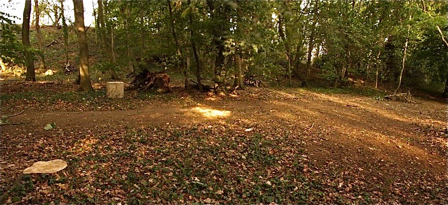
The clearance enabled us to press on with a detailed survey of the earthwork including planning and the drawing of profiles.
As the leaves continued to fall and the remaining vegetation die back
it became increasingly easy to appreciate the sheer scale of the
monument and its relationship with Sourland Pool and the views from the
hall. It is quite instructive to compare the latest plan with the sketch plan drawn up during the summer by crawling through the undergrowth with a compass, not a bad effort I think
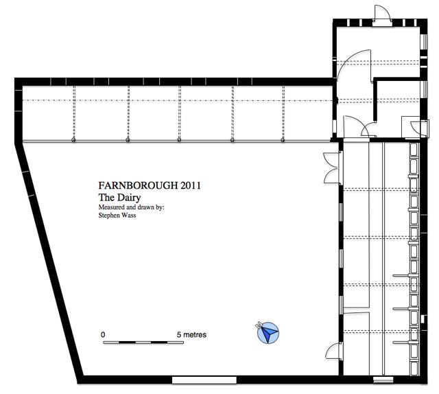
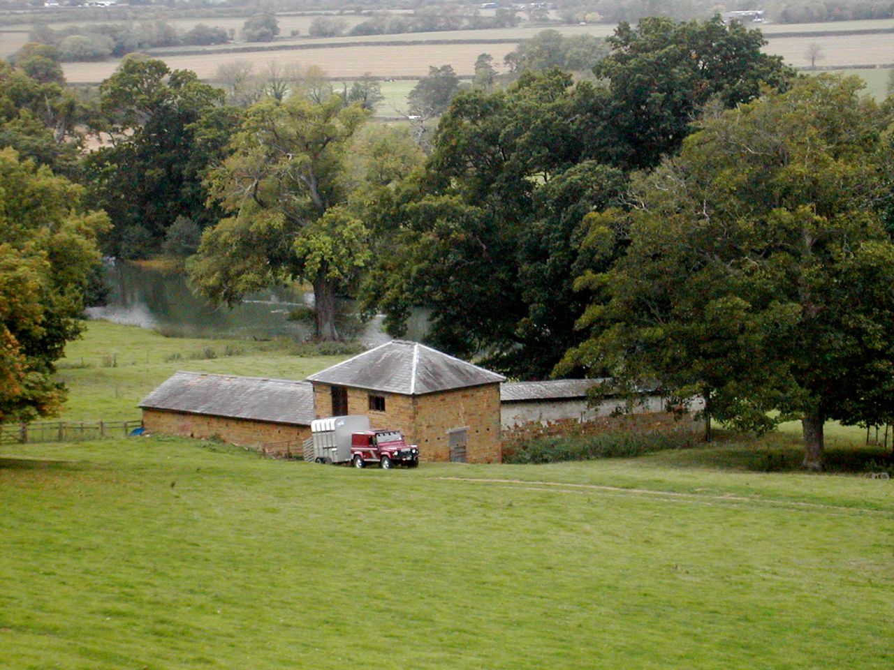
The Dairy
Sitting in the middle of the field to the south-west of the hall is a complex agricultural building known as the Dairy. Not surprisingly the field is called The Dairy in the 1771 estate map but it is by no means clear what exactly is shown at the site of the building. The late Georgian structure appears to be hexagonal which may be an illusion caused by poor photocopying. Whatever the case it is hard to reconcile existing remains with such a layout. In plan the building appears to be quite straight forward with two wings: one to the south-west being cowshed while that to the north west is a livestock shelter. the tow are joined by a two storey feed store. However even a cursory look at the north-east elevation reveal at least six building periods and a plethora of blocked openings and extraordinarily high quality stonework capped with brick. This will take some sorting out and currently involves drawing a stone by stone elevation of the north-east wall - should be over by Christmas!
And indeed it was, more or less, another assignment for Leicester delivered on January 20th. You can read the first draft here... there are just 8,300 words... on a cow shed! Actually, I had to cut it down to 6,000 words before sending it off - probably and improvement.
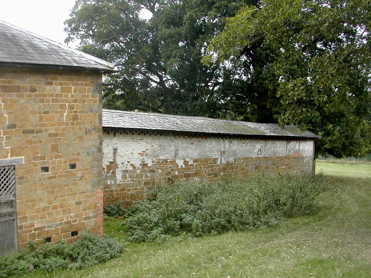
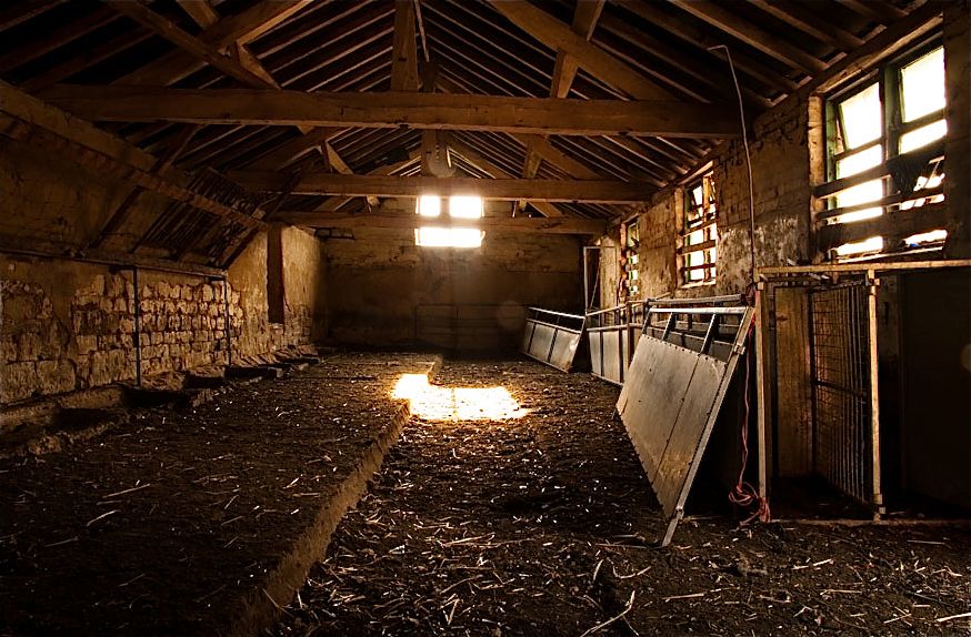
The Dairy from the east. North-east elevation. Interior of the cowshed (Photo by Chris Mitchell)
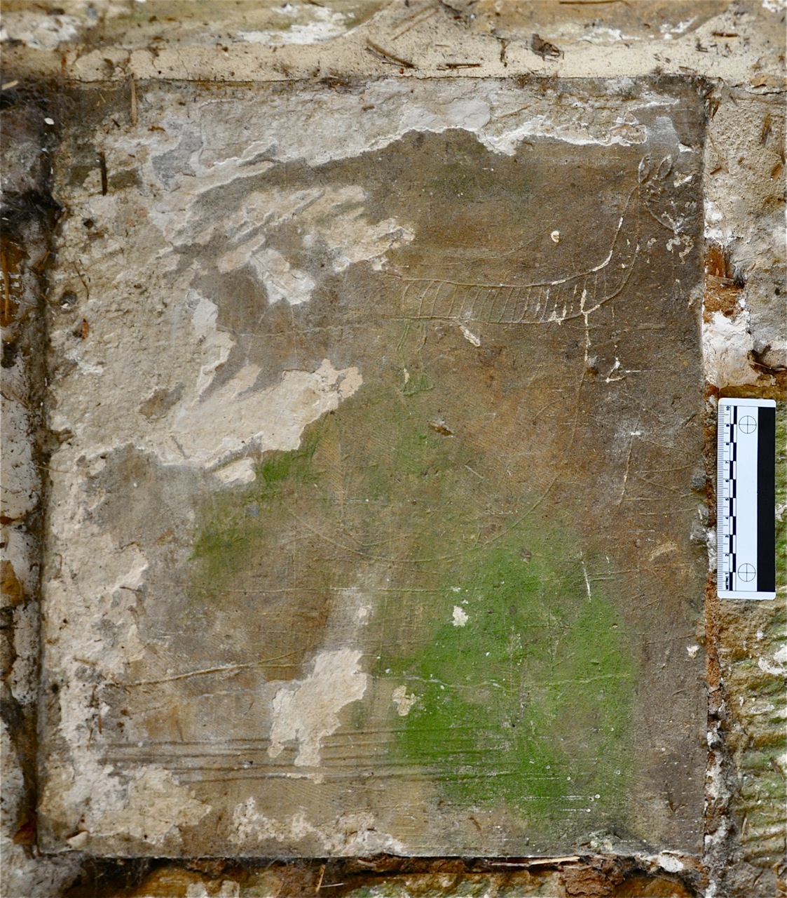
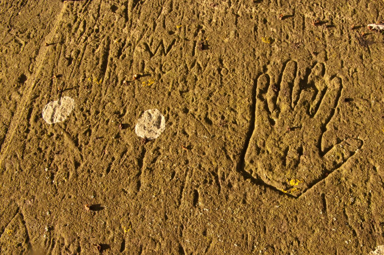
Detailed
study of the stonework on the Dairy threw up two interesting finds.
Firstly on the inner wall of the livestock shelter we found a
remarkable piece of graffiti: a horse or donkey, its body shaded
in with vertical stripes giving it something of the look of a zebra!
The block was clearly reused as the poor beast was nose down, I've
turned the photo through 90 degrees to give a better view of it all.
There are plenty of other marks on the stone, is it all part of a
countryside scene with fields and fences?
We have also been puzzling over some reused stone blocks on the outer wall.The faces have been carefully finished in a style known as tooled work using a special form of chisel called a claw boaster. Most of the faces of the stones are dressed with vertical furrows but the vertical edges are marked with horizontal dressing to a width of around 50 mm. I searched in vain for other local examples then found three exact parallels at Chiswick House! What does it all mean?
The continuing run of fine mild weather really made October and November particularly productive, here are few more snippets:
Illicit Pig Roasting at Farnborough?
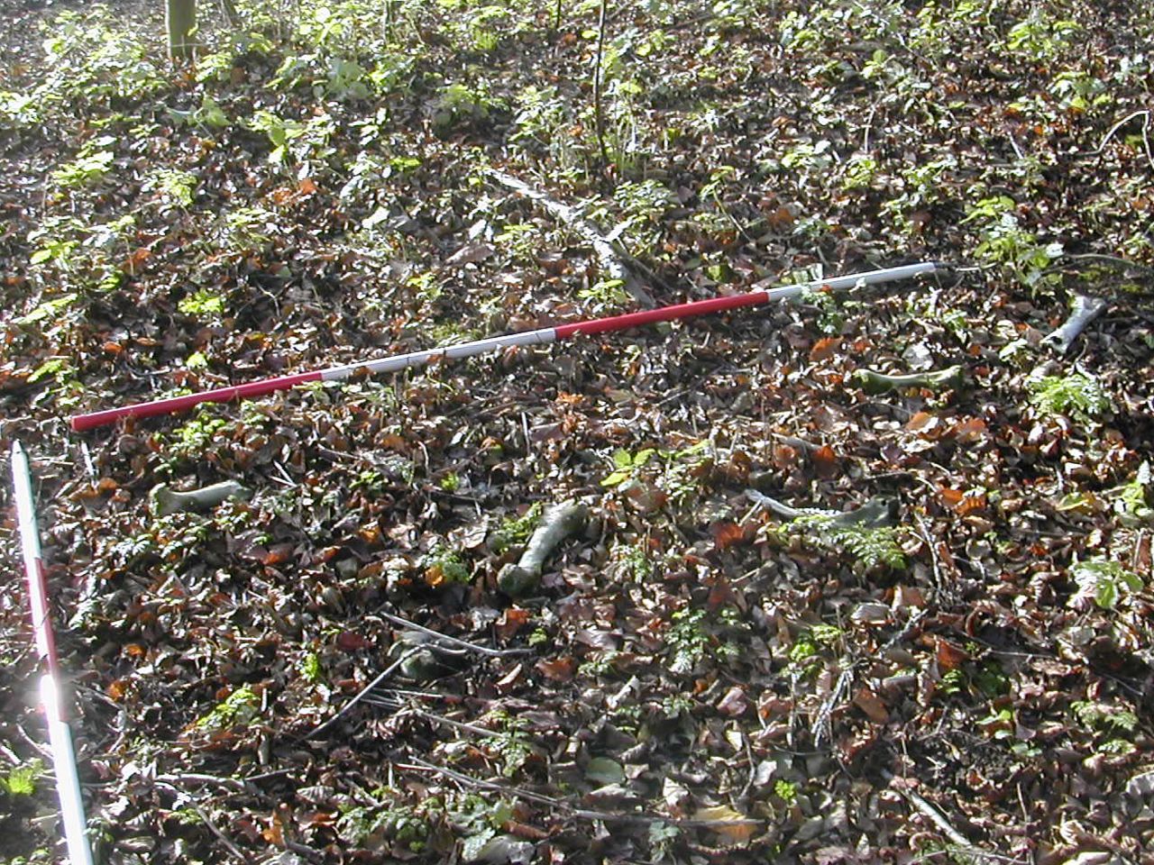
One of the advantages of going over the ground repeatedly is you get the opportunity to see things that were previously overgrown. Several weeks earlier Peter Braybrook, a volunteer, and myself had been making our way round to the north side of the Canal when in the small patch of woodland next to the road we stumbled upon a scatter of bones. These were clearly pig bones from an extremely robust individual. What on earth were they doing here? Late night pig roasting? We certainly were not aware of any pig farming going on in the immediate vicinity. then local inquiries unearthed the tale that several years ago a wild boar had escaped from a farm further north into Warwickshire but more than that a local resident reported running in to such a beast (literally) in a car. Could these be the bones of the boar who, having been struck by a vehicle, dragged himself off into the undergrowth to die? Only the major bones remain presumably the lesser ones were scattered or dragged off by scavengers. In addition some of the bones show clear indications of gnawing. the marks look rather large for rats, would something like a badger chew on pig bones?
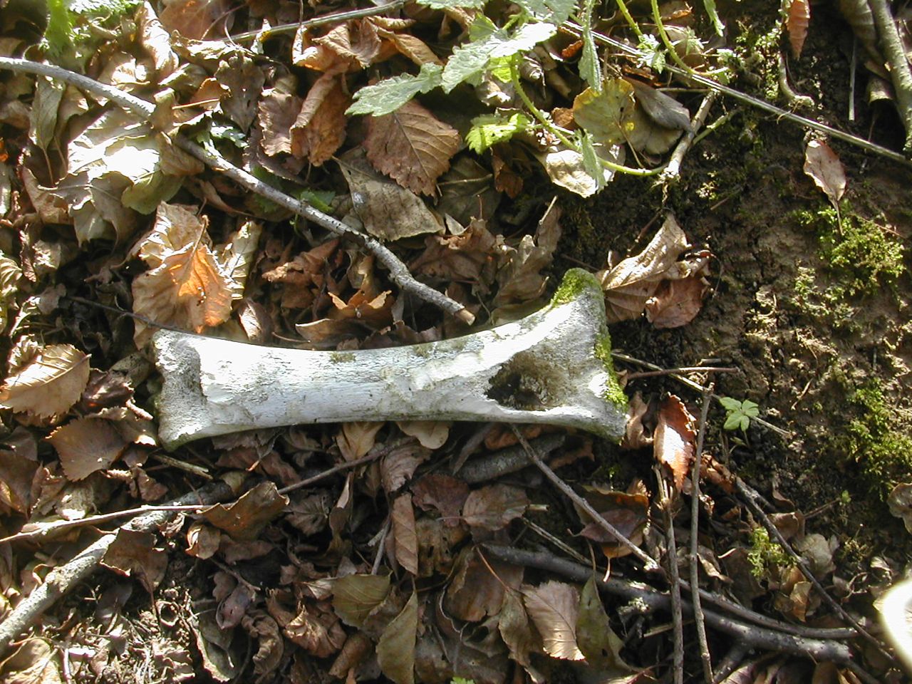
Remains of the wild boar? Close up of gnawed bone
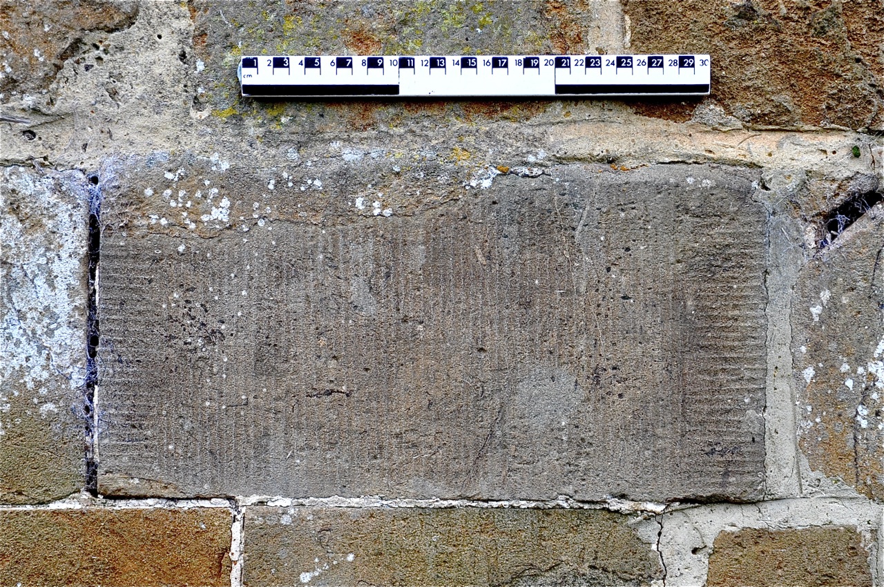
Graffiti Revealed
We had long been aware to the graffiti carved into the parapet of the bridge on the lane to Banbury but late in November, on a particularly fine sunny morning, Chris Mitchell was able to take some remarkable close ups of the engraved letters, numbers and other marks. It is a valuable record to have and we hope at some time in the future to use various bits of image enhancing software to aid in their reading.
And now a word from our sponsor...
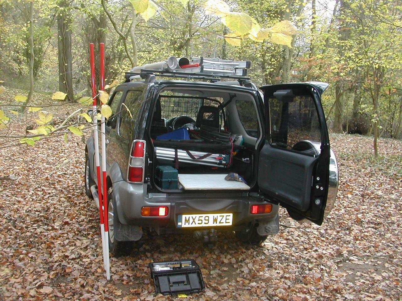
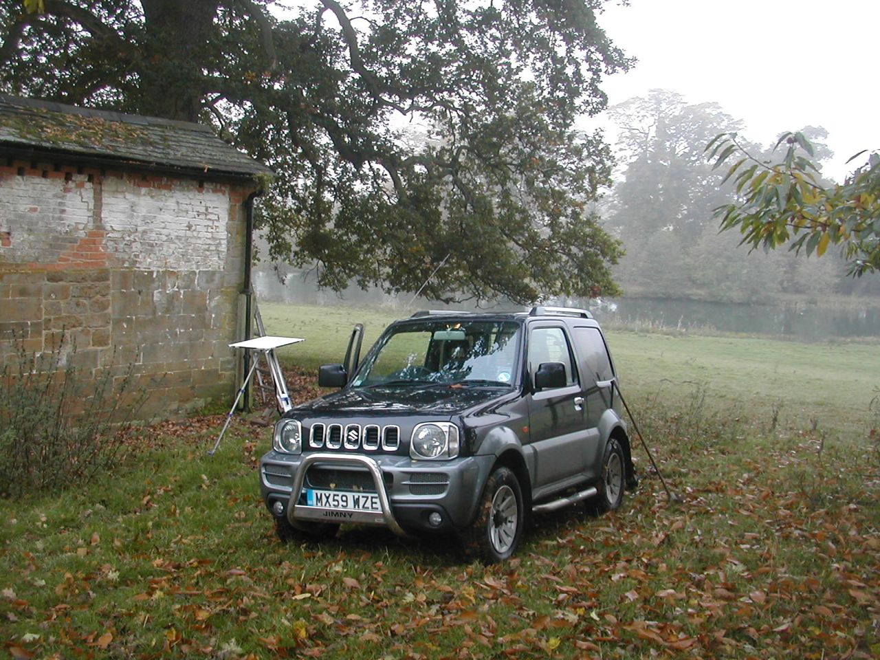
Not really, actually that's not such a bad idea.... Anyway my old VW Polo was approaching the end of its useful life and we made the decision to change it for something more productive. Several years ago I had owned one of the Suzuki 'mini-jeeps' : the Samurai and had used it in effect as a small pick-up truck. Designed for the jungles of South-east Asia these light weight, narrow beamed vehicles had a reputation for going places other 4 x 4s couldn't reach. So a call to the local Suzuki garage at Long Hanborough revealed that they had a number of the updated version - the Jimny- for sale, second hand. We came away with a remarkable vehicle which had had the rear seats removed and a boot liner and dog guard installed which struck us as ideal for toting around the equipment we need to work in increasingly remote sectors of the park. With a four wheel drive vehicle we could treat it as a kind of tool box on wheels and take it wherever we were working. To complement the existing fittings I also bought a set of roof bars and bolted onto that the kind of pipe carrier you see on plumbers' vans to store the ranging poles and a couple of ladder clamps as well. The only downside with this Jimny is that the previous owner had it pimped to within an inch of its life so that every conceivable part that could be chromed has been chromed plus it has front bars, side bars and a rear spoiler! Watch out for it on the road, there's nothing else quite like it around.
.
We have also been puzzling over some reused stone blocks on the outer wall.The faces have been carefully finished in a style known as tooled work using a special form of chisel called a claw boaster. Most of the faces of the stones are dressed with vertical furrows but the vertical edges are marked with horizontal dressing to a width of around 50 mm. I searched in vain for other local examples then found three exact parallels at Chiswick House! What does it all mean?
The continuing run of fine mild weather really made October and November particularly productive, here are few more snippets:
Illicit Pig Roasting at Farnborough?
One of the advantages of going over the ground repeatedly is you get the opportunity to see things that were previously overgrown. Several weeks earlier Peter Braybrook, a volunteer, and myself had been making our way round to the north side of the Canal when in the small patch of woodland next to the road we stumbled upon a scatter of bones. These were clearly pig bones from an extremely robust individual. What on earth were they doing here? Late night pig roasting? We certainly were not aware of any pig farming going on in the immediate vicinity. then local inquiries unearthed the tale that several years ago a wild boar had escaped from a farm further north into Warwickshire but more than that a local resident reported running in to such a beast (literally) in a car. Could these be the bones of the boar who, having been struck by a vehicle, dragged himself off into the undergrowth to die? Only the major bones remain presumably the lesser ones were scattered or dragged off by scavengers. In addition some of the bones show clear indications of gnawing. the marks look rather large for rats, would something like a badger chew on pig bones?
Remains of the wild boar? Close up of gnawed bone
Graffiti Revealed
We had long been aware to the graffiti carved into the parapet of the bridge on the lane to Banbury but late in November, on a particularly fine sunny morning, Chris Mitchell was able to take some remarkable close ups of the engraved letters, numbers and other marks. It is a valuable record to have and we hope at some time in the future to use various bits of image enhancing software to aid in their reading.
And now a word from our sponsor...
Not really, actually that's not such a bad idea.... Anyway my old VW Polo was approaching the end of its useful life and we made the decision to change it for something more productive. Several years ago I had owned one of the Suzuki 'mini-jeeps' : the Samurai and had used it in effect as a small pick-up truck. Designed for the jungles of South-east Asia these light weight, narrow beamed vehicles had a reputation for going places other 4 x 4s couldn't reach. So a call to the local Suzuki garage at Long Hanborough revealed that they had a number of the updated version - the Jimny- for sale, second hand. We came away with a remarkable vehicle which had had the rear seats removed and a boot liner and dog guard installed which struck us as ideal for toting around the equipment we need to work in increasingly remote sectors of the park. With a four wheel drive vehicle we could treat it as a kind of tool box on wheels and take it wherever we were working. To complement the existing fittings I also bought a set of roof bars and bolted onto that the kind of pipe carrier you see on plumbers' vans to store the ranging poles and a couple of ladder clamps as well. The only downside with this Jimny is that the previous owner had it pimped to within an inch of its life so that every conceivable part that could be chromed has been chromed plus it has front bars, side bars and a rear spoiler! Watch out for it on the road, there's nothing else quite like it around.
.