The Dairy, Farnborough Park,
Warwickshire.
52˚08‘ 19.36“N 1˚22‘ 24.07“W
OS Grid Reference SP429492
Back to Project
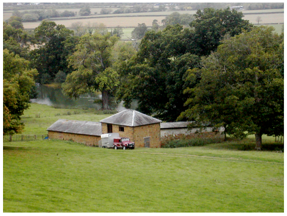
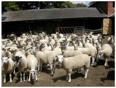
Fig. 1 The Dairy from the east Fig. 2 Sheep penned within the stockyard, looking north
Introduction
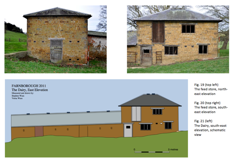
This small agricultural building stands in a central location within the landscaped park of Farnborough Hall, Warwickshire (Fig. 1). Its position within the park strongly suggests that it may be associated with that class of monuments sometimes known as fermes ornée – buildings which are essentially agricultural yet because of their prominence also display decorative elements employed either to disguise their true function or to enhance the aesthetic experience of the landscape. The building is only now occasionally used to shelter livestock, alternating between cattle and sheep (Fig. 2) but in its most recent fully functional form consisted of a stockyard with a shelter built along the north-east side, a milking parlour on the south-east side and a two storey feed store on the east corner at the junction of these two elements (Fig. 4). The orientation of the building and its precise setting within the park are points of considerable importance which we will consider later.
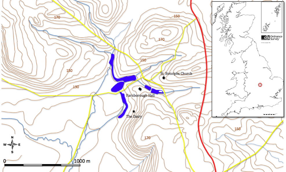
Fig. 3 Location map and topography
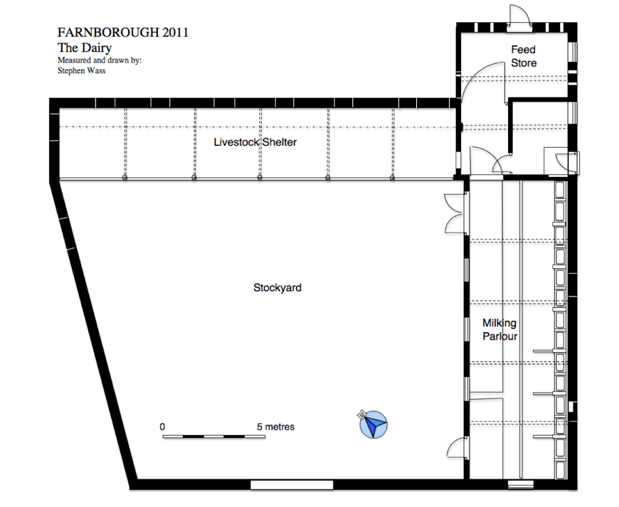
Fig.4 Site plan
This study is undertaken as part of a two year programme of contracted work for the National Trust, the present owners, to survey and record landscape features and buildings within the confines of the park as laid out in the 1740s by William Holbech, the owner, on the advice of the landscape architect Sanderson Miller. The project is largely staffed by volunteers from local heritage groups working under the direction of the author and under the supervision of the Trust’s regional archaeologist: Janine Young. Fieldwork on the Dairy was largely undertaken during October and November 2011. In the context of this report the dairy is capitalised as if a proper name. Although the building may have accommodated cattle the dairy proper where milk products were processed was, at least during the nineteenth century, located in part of a courtyarded service block attached to the main house (Holbech undated). In an estate map of the late eighteenth century (Linnell 1772 ) the field in which the Dairy sits is called Dairy Close but we have no information about what the building was originally named
The park is on the national register of parks and gardens and is listed as Grade 1 (Record 1304). Reference is also made to the park on the Warwickshire HER ( Record 6948) and a number of buildings within the park have individual records but in neither case is mention made of the Dairy. Documentary evidence is problematic for the site. Because Sanderson Miller was a ‘gentleman architect’ very little of his advice was written down or accounted for in the first place. The National Trust due to several relocations of regional offices have had difficulty accessing some of their archival material . Finally we have not yet had an opportunity to discuss access to the Holbech estate papers. However, the very paucity of documentation about the park serves to underline the importance of the present archaeological investigations.
Section 1 – Research Aims
As already noted the primary research aim is simply to record and document archaeological remains in and to certain extent adjoining the park. The main driver behind this is the simple fact that many of the associated monuments are in a very poor state and in some instances subject to the risk of imminent collapse, the cascade is a particular case in point. As survey results have become available these have been forwarded to the appropriate officers of the National Trust. Unfortunately given the economic difficulties currently experienced and the low numbers of visitors to Farnborough it is unlikely in the short term that much in the way of remedial work is likely to be carried out so in the event of further deterioration of park features the record will become increasingly important. Within this context the Dairy, which no longer has any real agricultural function, is at risk from the kind of poor maintenance and lack of care that has already lead to the collapse of two other minor agricultural buildings on the estate.
The park is neither well known nor well understood by either the academic community nor the public at large. This is not the place to make the argument but it seems clear that the work of Sanderson Miller and his role as mentor to Lancelot (Capability) Brown gives his ideas, as worked out at Farnborough, considerable historic significance. It is therefore a further aim to use studies such as those of the Dairy to further develop an understanding of Miller’s approach to landscape design and especially the physicality of the materials and techniques he commissioned. Extensive work on Farnborough has already been carried out by Jennifer Meir, who in the course of two papers ( Meir 1997 and 2002) and one book (Meir 2006) has created an account of the corpus of Miller’s work and begun the process of contextualizing it. However, despite having a very clear focus on the landscape elements of his garden designs and having carried out some field work, in the case of Farnborough her analysis was made on the basis of partial evidence so it becomes a further aim that this analysis be reappraised in the light of the current discoveries that are being made and questions that will be raised about the dating of the Dairy.
Whilst archaeological research into the core areas of estate landscapes are, ‘well established’, Williamson reminds us that, ‘the study of the estate as an entity, in its entirety, including the wider penumbra of tenanted farmland is only just beginning, (Williamson 2007: 1). It is therefore a long term aim to place the study of this building within the wider context of other estate buildings and indeed other farm buildings both within the vernacular and ‘polite’ traditions of construction. This will help establish some understanding of the economic and social implications of structures which represent a compromise based on the notion of having to serve both aesthetic and agricultural purposes.
The specific questions about the building which need to be answered to address the points above are firstly the initial age of the building and how it fits in with the established chronology of the development of the park and secondly the sequence and significance of the repeated remodelling of the building as evidenced both by the fabric of the building and its layout as recorded by the Ordnance Survey.
Section 2 – Methodology
As already noted the project is being undertaken with the National Trust but as the work was offered on a pro bona basis there is in effect no budget for the programme. This has had two main methodological consequences. Firstly all of those volunteers who have assisted with the work whilst having some relevant experience are not trained archaeologists or building surveyors so planned activities have incorporated elements of training. Secondly the lack of budget has meant that the equipment employed has been of the most basic kind so we have had to eschew some of the benefits of total station surveying, use of GIS systems and related CAD software. The fact that we have had to take a very painstaking hands on approach stretching over several weeks has meant that we have got to know the building and its context very well and this, together with the generous time scale we have allowed ourselves, has promoted both in depth knowledge of the structure and some discussions about possible interpretations of certain features.
In practical terms survey work was done using 50 and 30 metre fibre tapes together with a selection of hand tapes (Fig 5). Occasionally a hand held LASER measure was used to determine heights within the building that could not conveniently be reached by ladder. The vertical component of the survey was determined by setting up a temporary site datum then using an optical level to project a baseline all around the exterior of the building from which vertical measurements could be made. This was originally marked in chalk and then galvanised nails were carefully placed within the mortar joints from which lines could be run and to which tapes could be fastened. Special interest was shown in the mortars used and although chemical analysis was not undertaken samples were subject to detailed visual examination and description. A detailed photographic record was made using a Nikon D90 SLR digital camera.
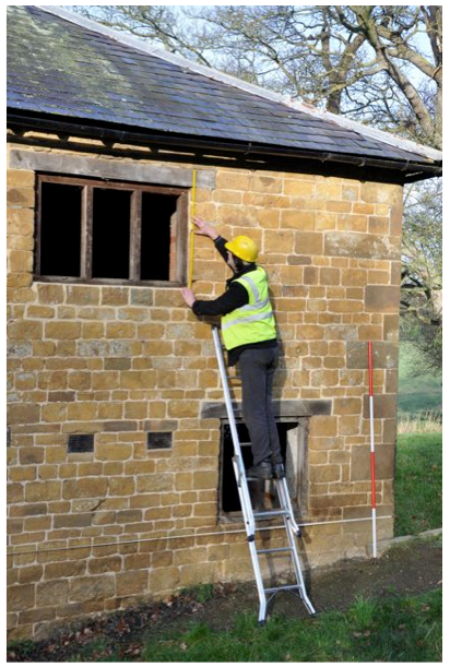
Fig 5 Survey work underway on the Dairy
Section 3 – History
Although a comprehensive history of the estate and its associated families has yet to be written the main strands of the park’s development as recorded as part of English Heritage’s listing process and outlined in the Trust’s guidebook are clear and for our purposes can be divided into five main significant periods.
1. in the late medieval period the manor was held by the Ralegh family who were probably responsible for locating the hall in its present position and created a small park to the south incorporating some medieval features (Wass 2011)
2. In 1684 the estate was purchased by Ambrose Holbech. The property was already partially mortgaged to him the suggestion being that the Raleghs had lost out financially during the Civil War. The Hall was rebuilt and it may be at this stage that work was begun on extending the park to the north.
3. In the 1740s Ambrose’s grandson William after undertaking the Grand Tour returned to Farnborough and in association with architect Sanderson Miler remodelled the park in a way which both echoed his interest in things classical but also prefigured the move in landscape design towards a more natural seeming setting with much use being made of borrowed landscape features (Meir 1997)
4. The grounds were further remodelled between 1815 and 1820 under the direction of garden designer Henry Hakewiell (English Heritage 2011). This work included the creation of a large walled garden and a number of other agricultural buildings which indicates that an attempt may have been made to put the estate on a more productive footing.
5. The twentieth century was one of decay and dissolution. Especially after the first World War large sections of the estate were sold off and it was a much smaller park which eventually was deeded to the National Trust in lieu of death duties in 1960. Since that time work round the park has concentrated almost exclusively on the gardens immediately next to the hall with some woodland management. Those portions of the park still under control of the Trust are let out for grazing cattle and sheep and most of the agricultural buildings have become derelict.
Section 4 – Setting
All buildings are best appreciated within the context of their landscape setting but in the case of the Dairy its position within the park and its relationship to the series of walkways designed to provide carefully structured experiences for visitors is important. The Dairy lies on the lower slopes of a westward facing escarpment – a northern outlier of the Cotswold Hills – at a height of 135 metres above Ordnance datum and roughly 10 metres above the flat valley bottom to the west and 30 metres below the brow of the hill to the east (Fig 3). The underlying geology consists of hill wash and eroded material derived from the underlying ferruginous liassic limestone known locally as ironstone.
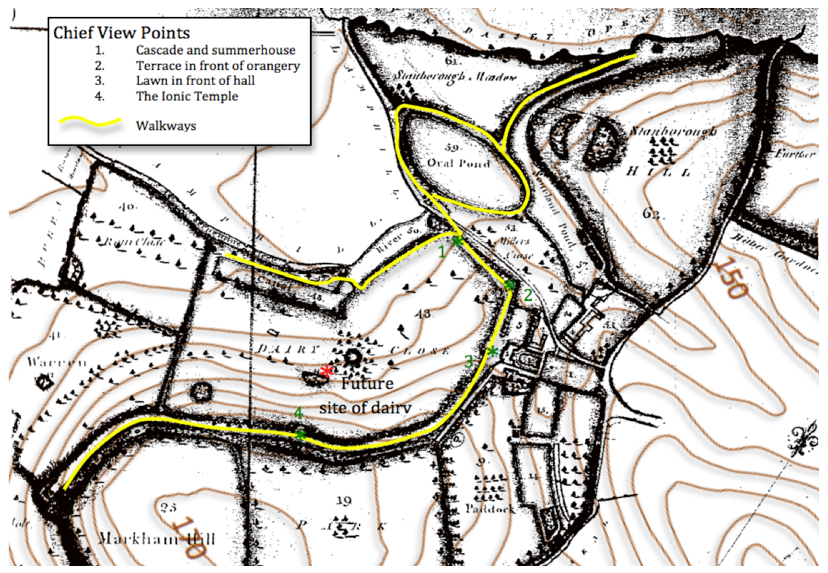
Fig. 6 The eighteenth century park as depicted by Linnell in 1772 with viewpoints and walkways as extant by c. 1820 with modern contours.
In the 18th century the valley bottom was modified to create a series of pools and the hill crest sculpted to create the famous terrace walk. This places the dairy visually close to the centre of the landscaped park and clearly visible from all of the surrounding walkways and viewpoints (Fig 6). The dairy is some 250 metres south of the hall and its associated service buildings and is linked to it by a terraced driveway which for a least some of its length was metalled with stone setts. However, the 1772 estate map which is our chief source for the layout of the park indicates that the dairy was not one of the Georgian improvements . Instead the location is occupied by a rectangular block of planting at the centre of which is marked a curious thick bordered hexagonal structure. Given the propensity for other geometrically shaped plantings within the park: the semicircular and crescentic settings known today as the amphitheatre for example, this could be an enclosure set aside a particular grouping of trees. Whatever the case no trace of the arrangement is visible on the ground today. Another feature shown in the field labelled Dairy Close is a rectangular building around 100 metres south-west of the current Dairy which may be an earlier building which fulfilled a similar function. Again there are no surface indications of the structure. The dairy complex is orientated so that the main buildings are to the north and east of the stockyard partly so that the activities within the yard are hidden and that the building presents its most picturesque aspect to the visitor and partly so that the yard is sheltered from the cold north easterly winds.
Section 5 – Description of Building
i) Materials
The chief materials employed in the construction of this building are stone, brick, timber and slate, all of which with the exception of slate could be provided by the estate. As already noted the underlying rock is ironstone which whilst not a building stone of the first quality is widely used in the area and indeed apart from the quoins and dressings around the doors and windows is used in the hall itself. There are at lest two quarries within the park (Fig ) and there is no reason to suspect that the stone was brought from any further afield. The only exception are some clearly reused stones on the outer face of the livestock shelter which we will discuss below.
Brick is mainly used round the estate for walling and some nineteenth century and later minor buildings. Of particular interest is the brick work around the large walled garden constructed between 1815 and 1820 (English Heritage 2011). Local informants report that the bricks were made locally and point out a clay pit and site of brickworks on the north-east slope of Oakal Hill (fig. ). Although there is a strong likelihood that the bricks used for the feed store and milking parlour were made here it has to be said that they do not appear to share the same characteristics of colour and texture to those examined in the walled garden. However, one has to accept that due to the vagaries of craft brick making there can be considerable variation between different batches of bricks. The slates on the roofs which are all blue Welsh slate are obviously imports. Despite the fact that in the eighteenth and early nineteenth centuries there were local slate industries in Oxfordshire at Stonesfield and Colleyweston In Northamptonshire there is no evidence that they were used here. Welsh slates first became widely available in the region following the construction of the Oxford to Birmingham canal in 1769 (Wood-Jones 1963: 12).
The principle roof timbers and the frames of many of the windows and doors are in oak. Again this would have been widely available within the park. Oaks featured extensively in the eighteenth century planting and one felled example was dated to the 1740s by counting the tree rings (Wass 2011). The two massive support beams for the first floor of the feed store are elm and whilst, due to Dutch Elm Disease, it is impossible to comment on their occurrence in the park it seems likely they were part of the estate’s resource base. Some modern sawn softwood is used particularly where portions of the roof have been repaired or replaced.
ii) Foundations
Although it was not possible to examine foundations in any detail in a few places it was clear that the stone walls had foundations of at least one course of roughly cut blocks. Build up of the ground level elsewhere made it impossible to determine what foundations underpinned the brick walling. Whatever the case the arrangements must have been reasonably effective for despite its hill slope location there is little evidence of slippage or walls cracking or moving out of true. The only major structural crack is seen on the north-east face of the feed store.
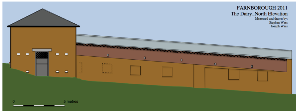
Fig. 7 The Dairy, north-east elevation, schematic view
iii) Livestock Shelter
This is without a doubt the most complex part of the building and even the most cursory glance at the outer wall reveals several phases of construction (Figs. 7 and 8). The present structure is an open-sided rectangular livestock shelter roughly 20 metres long and 4 metres wide. At its north-east end it abuts the feed store and is open to the yard to the south-west. The slate and timber roof is strongly asymmetric presenting a steep slope to the north east and gentler slope facing onto the yard. The roof is supported on this side by five large iron pipes. It is floored with a mixture of brick and stone slabs although details are hard to make out as much of the surface is caked in a deep hard packed layer of manure and decayed straw.
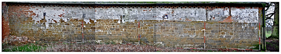
Fig. 8 Livestock shelter exterior of north-east wall, non-rectified mosaic photograph
This small agricultural building stands in a central location within the landscaped park of Farnborough Hall, Warwickshire (Fig. 1). Its position within the park strongly suggests that it may be associated with that class of monuments sometimes known as fermes ornée – buildings which are essentially agricultural yet because of their prominence also display decorative elements employed either to disguise their true function or to enhance the aesthetic experience of the landscape. The building is only now occasionally used to shelter livestock, alternating between cattle and sheep (Fig. 2) but in its most recent fully functional form consisted of a stockyard with a shelter built along the north-east side, a milking parlour on the south-east side and a two storey feed store on the east corner at the junction of these two elements (Fig. 4). The orientation of the building and its precise setting within the park are points of considerable importance which we will consider later.
Fig. 3 Location map and topography
Fig.4 Site plan
This study is undertaken as part of a two year programme of contracted work for the National Trust, the present owners, to survey and record landscape features and buildings within the confines of the park as laid out in the 1740s by William Holbech, the owner, on the advice of the landscape architect Sanderson Miller. The project is largely staffed by volunteers from local heritage groups working under the direction of the author and under the supervision of the Trust’s regional archaeologist: Janine Young. Fieldwork on the Dairy was largely undertaken during October and November 2011. In the context of this report the dairy is capitalised as if a proper name. Although the building may have accommodated cattle the dairy proper where milk products were processed was, at least during the nineteenth century, located in part of a courtyarded service block attached to the main house (Holbech undated). In an estate map of the late eighteenth century (Linnell 1772 ) the field in which the Dairy sits is called Dairy Close but we have no information about what the building was originally named
The park is on the national register of parks and gardens and is listed as Grade 1 (Record 1304). Reference is also made to the park on the Warwickshire HER ( Record 6948) and a number of buildings within the park have individual records but in neither case is mention made of the Dairy. Documentary evidence is problematic for the site. Because Sanderson Miller was a ‘gentleman architect’ very little of his advice was written down or accounted for in the first place. The National Trust due to several relocations of regional offices have had difficulty accessing some of their archival material . Finally we have not yet had an opportunity to discuss access to the Holbech estate papers. However, the very paucity of documentation about the park serves to underline the importance of the present archaeological investigations.
Section 1 – Research Aims
As already noted the primary research aim is simply to record and document archaeological remains in and to certain extent adjoining the park. The main driver behind this is the simple fact that many of the associated monuments are in a very poor state and in some instances subject to the risk of imminent collapse, the cascade is a particular case in point. As survey results have become available these have been forwarded to the appropriate officers of the National Trust. Unfortunately given the economic difficulties currently experienced and the low numbers of visitors to Farnborough it is unlikely in the short term that much in the way of remedial work is likely to be carried out so in the event of further deterioration of park features the record will become increasingly important. Within this context the Dairy, which no longer has any real agricultural function, is at risk from the kind of poor maintenance and lack of care that has already lead to the collapse of two other minor agricultural buildings on the estate.
The park is neither well known nor well understood by either the academic community nor the public at large. This is not the place to make the argument but it seems clear that the work of Sanderson Miller and his role as mentor to Lancelot (Capability) Brown gives his ideas, as worked out at Farnborough, considerable historic significance. It is therefore a further aim to use studies such as those of the Dairy to further develop an understanding of Miller’s approach to landscape design and especially the physicality of the materials and techniques he commissioned. Extensive work on Farnborough has already been carried out by Jennifer Meir, who in the course of two papers ( Meir 1997 and 2002) and one book (Meir 2006) has created an account of the corpus of Miller’s work and begun the process of contextualizing it. However, despite having a very clear focus on the landscape elements of his garden designs and having carried out some field work, in the case of Farnborough her analysis was made on the basis of partial evidence so it becomes a further aim that this analysis be reappraised in the light of the current discoveries that are being made and questions that will be raised about the dating of the Dairy.
Whilst archaeological research into the core areas of estate landscapes are, ‘well established’, Williamson reminds us that, ‘the study of the estate as an entity, in its entirety, including the wider penumbra of tenanted farmland is only just beginning, (Williamson 2007: 1). It is therefore a long term aim to place the study of this building within the wider context of other estate buildings and indeed other farm buildings both within the vernacular and ‘polite’ traditions of construction. This will help establish some understanding of the economic and social implications of structures which represent a compromise based on the notion of having to serve both aesthetic and agricultural purposes.
The specific questions about the building which need to be answered to address the points above are firstly the initial age of the building and how it fits in with the established chronology of the development of the park and secondly the sequence and significance of the repeated remodelling of the building as evidenced both by the fabric of the building and its layout as recorded by the Ordnance Survey.
Section 2 – Methodology
As already noted the project is being undertaken with the National Trust but as the work was offered on a pro bona basis there is in effect no budget for the programme. This has had two main methodological consequences. Firstly all of those volunteers who have assisted with the work whilst having some relevant experience are not trained archaeologists or building surveyors so planned activities have incorporated elements of training. Secondly the lack of budget has meant that the equipment employed has been of the most basic kind so we have had to eschew some of the benefits of total station surveying, use of GIS systems and related CAD software. The fact that we have had to take a very painstaking hands on approach stretching over several weeks has meant that we have got to know the building and its context very well and this, together with the generous time scale we have allowed ourselves, has promoted both in depth knowledge of the structure and some discussions about possible interpretations of certain features.
In practical terms survey work was done using 50 and 30 metre fibre tapes together with a selection of hand tapes (Fig 5). Occasionally a hand held LASER measure was used to determine heights within the building that could not conveniently be reached by ladder. The vertical component of the survey was determined by setting up a temporary site datum then using an optical level to project a baseline all around the exterior of the building from which vertical measurements could be made. This was originally marked in chalk and then galvanised nails were carefully placed within the mortar joints from which lines could be run and to which tapes could be fastened. Special interest was shown in the mortars used and although chemical analysis was not undertaken samples were subject to detailed visual examination and description. A detailed photographic record was made using a Nikon D90 SLR digital camera.
Fig 5 Survey work underway on the Dairy
Section 3 – History
Although a comprehensive history of the estate and its associated families has yet to be written the main strands of the park’s development as recorded as part of English Heritage’s listing process and outlined in the Trust’s guidebook are clear and for our purposes can be divided into five main significant periods.
1. in the late medieval period the manor was held by the Ralegh family who were probably responsible for locating the hall in its present position and created a small park to the south incorporating some medieval features (Wass 2011)
2. In 1684 the estate was purchased by Ambrose Holbech. The property was already partially mortgaged to him the suggestion being that the Raleghs had lost out financially during the Civil War. The Hall was rebuilt and it may be at this stage that work was begun on extending the park to the north.
3. In the 1740s Ambrose’s grandson William after undertaking the Grand Tour returned to Farnborough and in association with architect Sanderson Miler remodelled the park in a way which both echoed his interest in things classical but also prefigured the move in landscape design towards a more natural seeming setting with much use being made of borrowed landscape features (Meir 1997)
4. The grounds were further remodelled between 1815 and 1820 under the direction of garden designer Henry Hakewiell (English Heritage 2011). This work included the creation of a large walled garden and a number of other agricultural buildings which indicates that an attempt may have been made to put the estate on a more productive footing.
5. The twentieth century was one of decay and dissolution. Especially after the first World War large sections of the estate were sold off and it was a much smaller park which eventually was deeded to the National Trust in lieu of death duties in 1960. Since that time work round the park has concentrated almost exclusively on the gardens immediately next to the hall with some woodland management. Those portions of the park still under control of the Trust are let out for grazing cattle and sheep and most of the agricultural buildings have become derelict.
Section 4 – Setting
All buildings are best appreciated within the context of their landscape setting but in the case of the Dairy its position within the park and its relationship to the series of walkways designed to provide carefully structured experiences for visitors is important. The Dairy lies on the lower slopes of a westward facing escarpment – a northern outlier of the Cotswold Hills – at a height of 135 metres above Ordnance datum and roughly 10 metres above the flat valley bottom to the west and 30 metres below the brow of the hill to the east (Fig 3). The underlying geology consists of hill wash and eroded material derived from the underlying ferruginous liassic limestone known locally as ironstone.
Fig. 6 The eighteenth century park as depicted by Linnell in 1772 with viewpoints and walkways as extant by c. 1820 with modern contours.
In the 18th century the valley bottom was modified to create a series of pools and the hill crest sculpted to create the famous terrace walk. This places the dairy visually close to the centre of the landscaped park and clearly visible from all of the surrounding walkways and viewpoints (Fig 6). The dairy is some 250 metres south of the hall and its associated service buildings and is linked to it by a terraced driveway which for a least some of its length was metalled with stone setts. However, the 1772 estate map which is our chief source for the layout of the park indicates that the dairy was not one of the Georgian improvements . Instead the location is occupied by a rectangular block of planting at the centre of which is marked a curious thick bordered hexagonal structure. Given the propensity for other geometrically shaped plantings within the park: the semicircular and crescentic settings known today as the amphitheatre for example, this could be an enclosure set aside a particular grouping of trees. Whatever the case no trace of the arrangement is visible on the ground today. Another feature shown in the field labelled Dairy Close is a rectangular building around 100 metres south-west of the current Dairy which may be an earlier building which fulfilled a similar function. Again there are no surface indications of the structure. The dairy complex is orientated so that the main buildings are to the north and east of the stockyard partly so that the activities within the yard are hidden and that the building presents its most picturesque aspect to the visitor and partly so that the yard is sheltered from the cold north easterly winds.
Section 5 – Description of Building
i) Materials
The chief materials employed in the construction of this building are stone, brick, timber and slate, all of which with the exception of slate could be provided by the estate. As already noted the underlying rock is ironstone which whilst not a building stone of the first quality is widely used in the area and indeed apart from the quoins and dressings around the doors and windows is used in the hall itself. There are at lest two quarries within the park (Fig ) and there is no reason to suspect that the stone was brought from any further afield. The only exception are some clearly reused stones on the outer face of the livestock shelter which we will discuss below.
Brick is mainly used round the estate for walling and some nineteenth century and later minor buildings. Of particular interest is the brick work around the large walled garden constructed between 1815 and 1820 (English Heritage 2011). Local informants report that the bricks were made locally and point out a clay pit and site of brickworks on the north-east slope of Oakal Hill (fig. ). Although there is a strong likelihood that the bricks used for the feed store and milking parlour were made here it has to be said that they do not appear to share the same characteristics of colour and texture to those examined in the walled garden. However, one has to accept that due to the vagaries of craft brick making there can be considerable variation between different batches of bricks. The slates on the roofs which are all blue Welsh slate are obviously imports. Despite the fact that in the eighteenth and early nineteenth centuries there were local slate industries in Oxfordshire at Stonesfield and Colleyweston In Northamptonshire there is no evidence that they were used here. Welsh slates first became widely available in the region following the construction of the Oxford to Birmingham canal in 1769 (Wood-Jones 1963: 12).
The principle roof timbers and the frames of many of the windows and doors are in oak. Again this would have been widely available within the park. Oaks featured extensively in the eighteenth century planting and one felled example was dated to the 1740s by counting the tree rings (Wass 2011). The two massive support beams for the first floor of the feed store are elm and whilst, due to Dutch Elm Disease, it is impossible to comment on their occurrence in the park it seems likely they were part of the estate’s resource base. Some modern sawn softwood is used particularly where portions of the roof have been repaired or replaced.
ii) Foundations
Although it was not possible to examine foundations in any detail in a few places it was clear that the stone walls had foundations of at least one course of roughly cut blocks. Build up of the ground level elsewhere made it impossible to determine what foundations underpinned the brick walling. Whatever the case the arrangements must have been reasonably effective for despite its hill slope location there is little evidence of slippage or walls cracking or moving out of true. The only major structural crack is seen on the north-east face of the feed store.
Although
it is clear that the buildings have been subject to many changes for
the purposes of this description we will use the nomenclaturebased
on the final stages of use namely the livestock shelter, the feed store, the milking parlour and the stockyard as used by the current tenant farmer (Fig. 4)
on the final stages of use namely the livestock shelter, the feed store, the milking parlour and the stockyard as used by the current tenant farmer (Fig. 4)
Fig. 7 The Dairy, north-east elevation, schematic view
iii) Livestock Shelter
This is without a doubt the most complex part of the building and even the most cursory glance at the outer wall reveals several phases of construction (Figs. 7 and 8). The present structure is an open-sided rectangular livestock shelter roughly 20 metres long and 4 metres wide. At its north-east end it abuts the feed store and is open to the yard to the south-west. The slate and timber roof is strongly asymmetric presenting a steep slope to the north east and gentler slope facing onto the yard. The roof is supported on this side by five large iron pipes. It is floored with a mixture of brick and stone slabs although details are hard to make out as much of the surface is caked in a deep hard packed layer of manure and decayed straw.
Fig. 8 Livestock shelter exterior of north-east wall, non-rectified mosaic photograph
There
are several remarkable features about this wall which demand a detailed
account. Rather than having stepped foundations and level courses the
stonework is built onto the hill side in such a way that the
courses follow the slope dipping down at an angle of around 5 degrees
from the horizontal. We have examined many similar buildings in the
area and conclude that this is not normal practice. Interestingly the
only other instance we have found is in the estate’s early nineteenth
century walled garden where here also the courses of brickwork run down
the hill. This has a curious effect on the widow openings whose
vertical sides mean that their overall shape is rhomboid. What makes
this method of construction even more curious is the very high quality
of the stone work at least towards the western end of the wall. Here
the blocks are ashlar: very smoothly dressed and finely cut with sharp
edges and precisely rectangular forms. The joints are even and narrow,
around 3 - 5 mm, and filled with fine white lime mortar. Seven of the
stones show an unusual pattern of dressing (Figs. 9 and 12). The
faces have been carefully dressed in a style known as tooled work
using a special form of chisel called a claw boaster (Jenkins 1978:
171). Most of the faces of the stones are dressed with vertical
furrows but the vertical edges are marked horizontal
dressing to a width of around 50 mm. (Fig. 9).
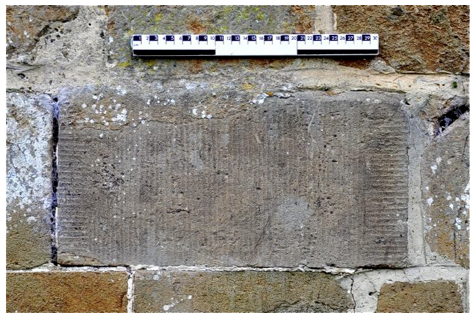
Fig. 9 North-east face of livestock shelter wall, tooled ashlar block
Despite careful searches of the estate and surrounding villages we have been unable to discover a parallel for this style of dressing and so their origins remain an open question. The point is that these stones clearly are reused from another context and this opens up the possibility that the ashlar in general is also reused.
We assume that construction work started at this end and moved up the slope to the east as the work becomes progressively less carefully executed, the stone blocks become rougher and the careful pattern of coursing breaks down. We will consider possible explanations for this in the final section. The outer face of the wall adjacent to the feed store has been completely rebuilt to a poor standard. The stone walling as currently presented stands to a height of around 180 mm. For the first 8 metres or so the stone walling has an offset near its upper edge so that subsequent courses are set back by around 40 mm. These remaining courses of stone rise to the east at a rather steeper angle.
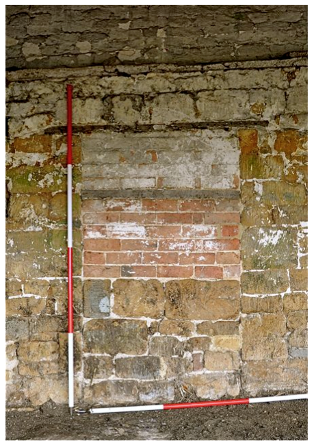
Initial examination of the outer face of the wall reveal an apparently symmetrical arrangement of a doorway flanked by two pairs of roughly square windows at centres of around 3 metres. These are all now blocked. In the case of the door this was done in three phases. The lowest portion of blocking uses similar types of stone and lime mortar suggesting that the door was converted into a window fairly shortly after its initial construction. The remainder of the blocking was done in brick on the inside and stone on the outside but the presence of an intermediate timber lintel on the inside suggests the window was lowered before being completely sealed. (Fig. 10 ). Similarly the windows immediately adjacent to the former doorway were also lowered then blocked up whilst the outermost windows of the four were closed in a single operation, again with brick on the inside and stone on the outside.
Interestingly the mortar which accompanies the outer face of the stone blocking is based on Portland Cement whilst the inner skin of brickwork has a lime mortar. Suggesting that the stone infill may be a later replacement of the outer skin of bricks. In terms of the overall disposition of openings the outside elevation is misleading for an examination of the inside of the same wall shows there to have been two further windows to the east which are completely invisible from the outside. These have similar dimensions and centres to those already noted but are blocked in stone (Fig. 11). The final window is only partially preserved as the end of the wall has been clearly cut away to insert the feed store.
A further phase in construction saw the wall being lifted by around 1.2 metres with a run of brick walling. The bonding pattern is based on English Garden Wall bond but is poorly carried out and may be best characterised as irregular until the top two courses are reached where stretchers alternate with voids the width of the headers as a measure to ensure improved ventilation. The width of the brick wall is considerably reduced compared to the stone walling below creating a ledge on the inside of which a wall plate sits. The mortar is lime based but is much coarser and full of inclusions including identifiable portions of shell.
A number of timbers appear inserted into the wall. The first set are the ends of the internal roof trusses which project through the full thickness of the wall. Two of the cut ends have been sealed with a piece of slate presumably to stop water penetrating the timber. A further series of blocked sockets and the shadows of timber work which has been removed after the walls had been lime-washed suggest the presence of a demolished lean-to. Again there are five such settings, initially thee coincide with the roof trusses at the east end but as their centres are a little closer together there is an appreciable gap towards the west (Fig . 12). The arrangement here seems to have consisted of triangular roof trusses attached to and projecting out from the wall presumably linked by a wall plate supported by vertical posts ( Fig. 13 ) We can assume that these spanned a distance of just under 4 metres taking the edge of the lean-to out to line up with the north face of the feed store. This is evidenced by the outline of the building as shown on the 1:10,550 Ordnance Survey map from 1885.
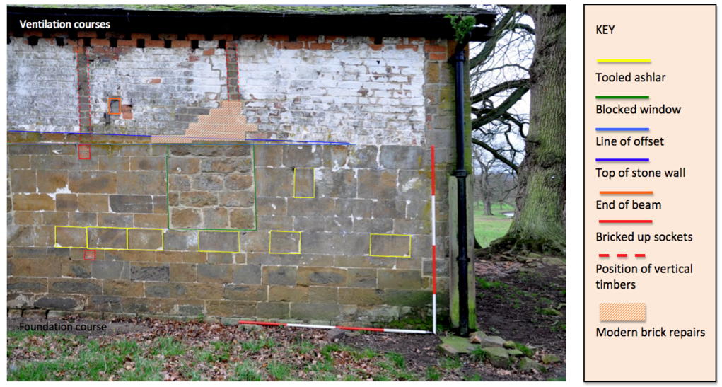
Fig. 12 The Livestock Shelter, north-east wall, western end showing construction details
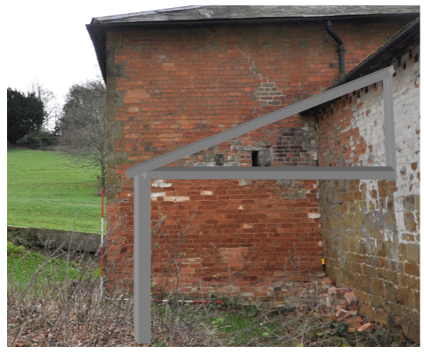
Fig. 13 Reconstruction of roof truss and post for lean-to
Fig. 9 North-east face of livestock shelter wall, tooled ashlar block
Despite careful searches of the estate and surrounding villages we have been unable to discover a parallel for this style of dressing and so their origins remain an open question. The point is that these stones clearly are reused from another context and this opens up the possibility that the ashlar in general is also reused.
We assume that construction work started at this end and moved up the slope to the east as the work becomes progressively less carefully executed, the stone blocks become rougher and the careful pattern of coursing breaks down. We will consider possible explanations for this in the final section. The outer face of the wall adjacent to the feed store has been completely rebuilt to a poor standard. The stone walling as currently presented stands to a height of around 180 mm. For the first 8 metres or so the stone walling has an offset near its upper edge so that subsequent courses are set back by around 40 mm. These remaining courses of stone rise to the east at a rather steeper angle.
Initial examination of the outer face of the wall reveal an apparently symmetrical arrangement of a doorway flanked by two pairs of roughly square windows at centres of around 3 metres. These are all now blocked. In the case of the door this was done in three phases. The lowest portion of blocking uses similar types of stone and lime mortar suggesting that the door was converted into a window fairly shortly after its initial construction. The remainder of the blocking was done in brick on the inside and stone on the outside but the presence of an intermediate timber lintel on the inside suggests the window was lowered before being completely sealed. (Fig. 10 ). Similarly the windows immediately adjacent to the former doorway were also lowered then blocked up whilst the outermost windows of the four were closed in a single operation, again with brick on the inside and stone on the outside.
Fig. 10 Door to livestock shelter internal blocking
Fig. 11 Window at eastern end, internal blocking
Interestingly the mortar which accompanies the outer face of the stone blocking is based on Portland Cement whilst the inner skin of brickwork has a lime mortar. Suggesting that the stone infill may be a later replacement of the outer skin of bricks. In terms of the overall disposition of openings the outside elevation is misleading for an examination of the inside of the same wall shows there to have been two further windows to the east which are completely invisible from the outside. These have similar dimensions and centres to those already noted but are blocked in stone (Fig. 11). The final window is only partially preserved as the end of the wall has been clearly cut away to insert the feed store.
A further phase in construction saw the wall being lifted by around 1.2 metres with a run of brick walling. The bonding pattern is based on English Garden Wall bond but is poorly carried out and may be best characterised as irregular until the top two courses are reached where stretchers alternate with voids the width of the headers as a measure to ensure improved ventilation. The width of the brick wall is considerably reduced compared to the stone walling below creating a ledge on the inside of which a wall plate sits. The mortar is lime based but is much coarser and full of inclusions including identifiable portions of shell.
A number of timbers appear inserted into the wall. The first set are the ends of the internal roof trusses which project through the full thickness of the wall. Two of the cut ends have been sealed with a piece of slate presumably to stop water penetrating the timber. A further series of blocked sockets and the shadows of timber work which has been removed after the walls had been lime-washed suggest the presence of a demolished lean-to. Again there are five such settings, initially thee coincide with the roof trusses at the east end but as their centres are a little closer together there is an appreciable gap towards the west (Fig . 12). The arrangement here seems to have consisted of triangular roof trusses attached to and projecting out from the wall presumably linked by a wall plate supported by vertical posts ( Fig. 13 ) We can assume that these spanned a distance of just under 4 metres taking the edge of the lean-to out to line up with the north face of the feed store. This is evidenced by the outline of the building as shown on the 1:10,550 Ordnance Survey map from 1885.
Fig. 12 The Livestock Shelter, north-east wall, western end showing construction details
Fig. 13 Reconstruction of roof truss and post for lean-to
The
gable end wall to the north-west is stone construction throughout and
shows similar fine quality masonry to the long wall for the first two
metres or so of its height. Above that the walling becomes a little
less regular presumably reflecting the remodelling undertaken when the
brick panel was added. There is a blocked window with a timber lintel
tucked just under the eaves. As already noted this aspect of the roof
is strongly asymmetric.
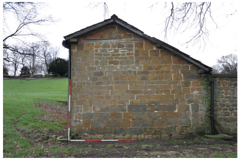
Fig. 14 Livestock shelter, north-west gable end wall
The lower inside faces of both walls are constructed in roughly coursed rubble except around the edges of the window and door openings and on the internal corner. Here we have more evidence for the reuse of ashlar as one of these corner blocks sports some intriguing graffiti showing amongst other things a small horse or donkey. The body is filled with vertical stripes as shading which are reminiscent of a zebra! The hocks on the rear legs are shown reasonably accurately but the rear end seems to fan out in an indeterminate way. Other carvings on the stone suggest that the animal may be part of a larger countryside scene. Unfortunately some of the markings are obscured by coats of lime-wash. The fact that this animal is now nose down indicates the block has been reset.
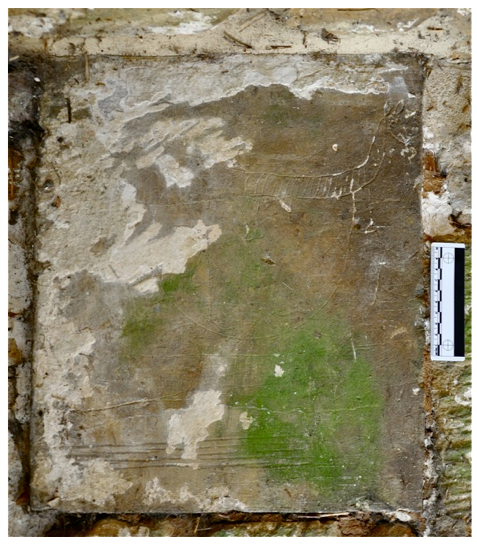
Fig. 15 Livestock shelter, inside of north corner, graffiti. The block has been rotated through 90 degrees to make the image easier to read.
As one might expect the detail of the roof construction shares in the complexity of the walling (Fig. 16). Essentially we have an oak framed king post roof which is the result of considerable alteration to what was probably a couple-close rafter roof. There are five trusses in all at centres of approximately 3.5 metres. The western most of these has been drawn and studied in detail and shows elements of construction and modification which are typical of the roof as a whole (Fig. 17). The tie-beam has a span of just under 5 metres and has a flat chamfers for most of its length. The end facing the stockyard rests on a wall-plate upon a tapered piece of timber supported on an open sided square section angle iron which is set into two parallel cuts in the top of a large diameter iron pipe (Fig. 18). An iron bracket offers additional support to the tie-beam .
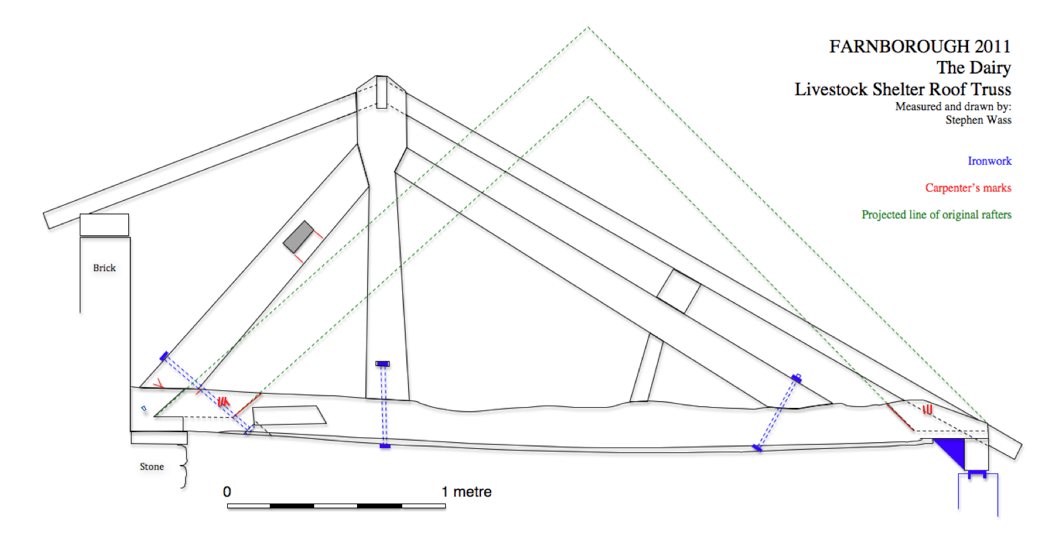
Fig. 16 Livestock shelter, elevation of western-most roof truss
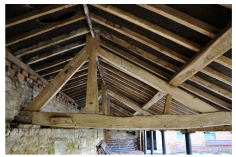
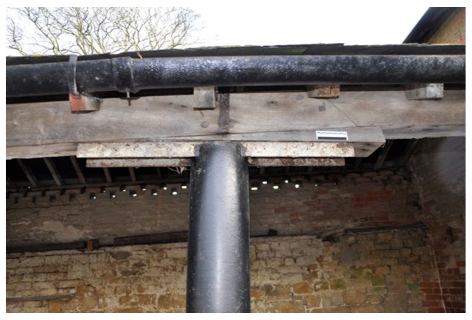
Fig. 17 Livestock shelter roof structure Fig. 18 Livestock shelter, detail of support
Fig. 14 Livestock shelter, north-west gable end wall
The lower inside faces of both walls are constructed in roughly coursed rubble except around the edges of the window and door openings and on the internal corner. Here we have more evidence for the reuse of ashlar as one of these corner blocks sports some intriguing graffiti showing amongst other things a small horse or donkey. The body is filled with vertical stripes as shading which are reminiscent of a zebra! The hocks on the rear legs are shown reasonably accurately but the rear end seems to fan out in an indeterminate way. Other carvings on the stone suggest that the animal may be part of a larger countryside scene. Unfortunately some of the markings are obscured by coats of lime-wash. The fact that this animal is now nose down indicates the block has been reset.
Fig. 15 Livestock shelter, inside of north corner, graffiti. The block has been rotated through 90 degrees to make the image easier to read.
As one might expect the detail of the roof construction shares in the complexity of the walling (Fig. 16). Essentially we have an oak framed king post roof which is the result of considerable alteration to what was probably a couple-close rafter roof. There are five trusses in all at centres of approximately 3.5 metres. The western most of these has been drawn and studied in detail and shows elements of construction and modification which are typical of the roof as a whole (Fig. 17). The tie-beam has a span of just under 5 metres and has a flat chamfers for most of its length. The end facing the stockyard rests on a wall-plate upon a tapered piece of timber supported on an open sided square section angle iron which is set into two parallel cuts in the top of a large diameter iron pipe (Fig. 18). An iron bracket offers additional support to the tie-beam .
Fig. 16 Livestock shelter, elevation of western-most roof truss
Fig. 17 Livestock shelter roof structure Fig. 18 Livestock shelter, detail of support
The
pipes consist of two or three lengths welded together and are pierced
at frequent intervals by small circular holes. The other end of the
tie-beam rests on a much decayed wall plate which sits on top of the
stone walling. A repair has been done here with a new end piece to be
beam being spliced in with a splayed scarf joint with a square vertical
abutment on the lower margin (Brunskill 1985: 147). An eccentrically
placed tapered king post supports a ridge board and is flanked by two
principal rafters. Obviously the one facing the yard is considerably
longer than the other and has additional support from a raking strut.
As well as being set into mortises in the tie-beam the king post and
principal rafters are also bolted in place. The longer principal rafter
supports a large square section purlin which in turn supports the
softwood common rafters most of which appear to be modern. On the wall
side the principal rafter is pierced for a through purlin which is no
longer in place. This side of the roof was clearly raised when the
additional height was added with the brick walling and the common
rafters simply span the small gap between the ridge and the new
wall-plate. A series of carpenter’s marks offer some clues to an
earlier configuration of this roof. Chisel cut carpenter’s marks which
do not match with marks on the rafters reveal the presence of two
further sockets on the upper surface of the tie beam. Guidelines
scribed on the vertical face of the tie beam emphasise the angles
at which the former principal rafters were raised and reveal the fact
that the roof was originally symmetrically pitched (Fig. 16).
iv) Feed store
This oblong two storey brick and stone block under a slate roof is just over 7 metres long by 5 metres wide and stands to an eaves height of 4 metres (Figs. 4 and 21). It appears to be largely of a single build and apart from a few internal fittings remains essentially unaltered. The north-east and south-west walls which face towards the hall and the south terrace are stone faced but brick on the inside. The stone work in the north-east wall is of well coursed but roughly dressed ironstone with ashlar quoins and some repairs in brick on the northern corner (Fig. 19). The south-east wall is similarly constructed but the stones in the lower courses are larger and better finished and seem to be a continuation of the low stone wall of the milking parlour onto which an upper floor has been added (Fig. 20). This situation contrasts with junction with the livestock shelter where the wall has clearly been truncated to accommodate the new block. The south-east and north-east walls are brick throughout whist the hipped roof is covered in Welsh slates with galvanised metal flashing and blue ridge tiles, two of which are raised to improve ventilation. There is a centrally placed oak framed doorway in the north-east wall in three sections. The uppermost is a latticework ventilation grill and below that are separate leaves, an upper and a lower typical of openings designed for livestock use. Eight cast iron ventilation grills (one of them now obscured) are placed symmetrically around this door. The south-east elevation has the most openings, all of them oak framed. On the ground floor an single leaf doorway is placed close to the south corner and there are two window openings. The first, closest to the door, has three lights divided up by two timber mullions (Fig. 22).
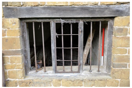
Fig. 22 Feed store, ground floor window
The
milking parlour retains considerable traces of the internal fittings
used for managing the feeding and milking of cows. Along the north east
wall is a rather crude manger made of thin section softwood and
large gauge wire mesh. Fastened to the wall are iron stanchions to
which cattle would be tethered via an iron ring which would enable the
head to be raised and lowered (Fig. 29). At the foot of the wall are
shallow feeding troughs formed in concrete over brick. The floor is
concrete and has a raised, gently sloping, area where the cattle would
stand and a broad shallow gutter for gathering manure. This has a
narrow drain to the outside to allow excess fluid to escape to the yard.
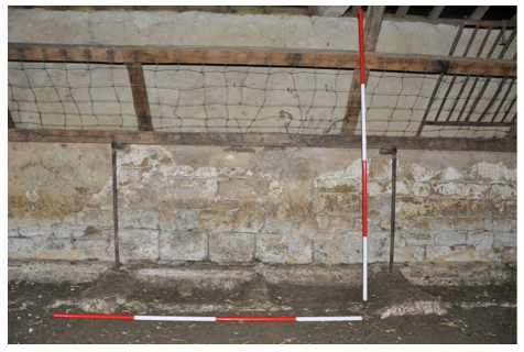
Fig. 29 Milking parlour, places for two cows against the south-east wall
vi) The Stockyard
Lying to the west of the buildings already described the stockyard is enclosed on the north-west and south-west sides by a stone wall between 1 and 1.5 metres high and constructed from a variety of stones ranging from rough rubble to scattered ashlar blocks. It is capped by flat stone slabs. The north-west wall does not lie in a straight line with the end of the shelter but returns at an angle of around 20 degrees, presumably because of the lie of the land, to create a trapezoidal enclosure (Fig. 4). There is a modern farm gate towards the middle of the south-west side (Fig. 30). The presence of two straight joints towards the north end of the north-west wall indicate a former entrance, an assumption backed up by the remains of a brick path and retaining wall which curves around towards the north-west end of the livestock shelter (Fig. 31). The present surface of the yard is ridged concrete with a fall to the north-west of 5 degrees to facilitate run off. There are two brick lined drains towards the middle of the north-west wall.
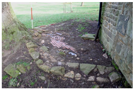
Fig. 30 Stockyard looking west Fig. 31 Remains of wall and brick paving north-west of shelter
Section 6 – Discussion and Analysis
i) Usage
Despite the many alterations it has been subject to it is clear that this complex of buildings has always been about the housing of cattle and in particular their care during the winter months. This care is expressed through three different systems of management all of which are evident within the structures. Brunskill sums up the strategies this way, ‘ Cattle were kept loose in yards which were open or partially covered; they were kept loose in small cattle boxes or they were kept tied in cow-houses’ (Brunskill 1982: 60). In simple terms bullocks and beef cattle were kept in the stockyard, sick cattle or cows about to calve would be kept in a loose box, sometimes called a hammel, and milk cattle were tethered in the cow-house. Typically in the late eighteenth and nineteenth centuries cattle were fed over the winter by a combination of hay, root crops and prepared ‘cattle-cake’ all of which was most conveniently stored at first floor level. Finally larger units sometimes made provision for the needs of the staff working with the cattle by setting aside a room to store equipment and materials perhaps with a desk or table where some record keeping could be done. All of these elements are present in the Dairy .
ii) Historical Development
Apart from the fact that development of the site seems to have begun post 1772 we have no fixed dates within the sequence of building and so have to create a floating chronology based on the principles of stratigraphy.
Despite their evident differences we have to assume that the well made dressed stone walls along the north-east and south-east sides of the site are the earliest constructions, however, the differences that exist in mortar and walling suggest they were not of a single build (Fig. 32). The erection of the feed store has eliminated any information about how these two structures were related but we may speculate on the basis of the extremely fine white lime mortar and the unusual quality of at least some of the stonework that the livestock shelter was built first. The fine quality of the stonework and the thin joints in white lime mortar argue that at least at the outset the intention was to build something designed either to be appealing visually or else reflect the high status of the structure. None of this makes much sense on terms of a cattle shed but of course the building is in a very prominent position within the park. Initial instructions could have gone out to the effect that a well made product was looked for. Whatever the case the quality of the work soon tailed off, possibly the supervising mason was called away and the work left to less skilled operators or possibly there was a shift in funding and the money was simply not available to carry on with a high standard of workmanship. Whatever the case having the best quality stonework on the whole estate, and this includes the hall, on the end of the cow-house is anomalous. Equally puzzling is the offset with coursing above rising to an even steeper angle (Fig. 12). This suggests that work was completed on at least the western most part of the building when the decision was taken progressively raise the eaves line. This seems to be further evidence of some additional problem with the structure if not growing incompetence.
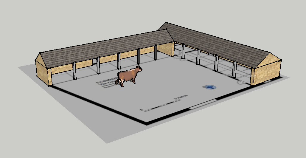
Fig. 32 Possible reconstruction of the earliest phases of the dairy using Google SketchUp.
Judging by the structural remains and parallels with other buildings in the locality this would have been a single storey open-sided structure under a conventionally pitched roof with tethering points and feeding places for 10 to 12 cattle. Sockets for the associated timberwork are scattered across the long wall’s inner face but the exact arrangement is hard to make out because of subsequent remodellings, however, a cow-house on the far side of Stanborough Meadow retains enough of its internal ittings to indicate a possible arrangement (Fig. 33). The windows are grouped so as to illuminate and ventilate a double stall and this may well have been the case with this early phase of the livestock shelter. In bad weather the openings were probably closed by shutters, examples of which survive in a cow-house just outside the estate on the Mollington Road (fig. 34). Brunskill makes much of the way in which arrangements for feeding cattle influenced the planning of cow-houses (Brunskill 1982: 61).
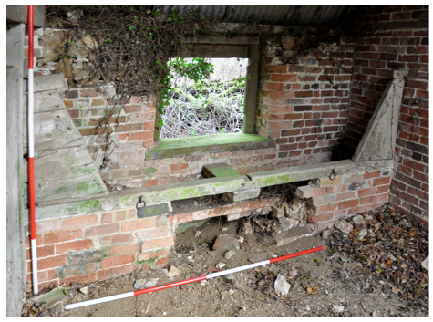
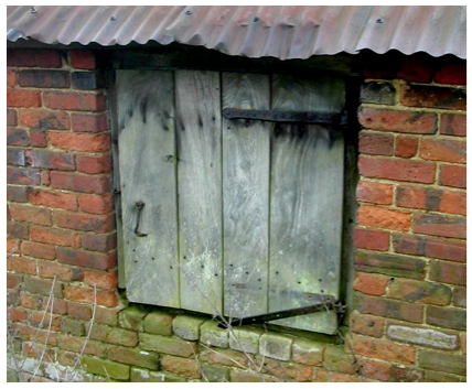
Fig. 33 Stanborough Meadow cow-house. Manger and tethering points Fig. 34 Shutter on nineteenth century cow-house, N of Mollington Road
iv) Feed store
This oblong two storey brick and stone block under a slate roof is just over 7 metres long by 5 metres wide and stands to an eaves height of 4 metres (Figs. 4 and 21). It appears to be largely of a single build and apart from a few internal fittings remains essentially unaltered. The north-east and south-west walls which face towards the hall and the south terrace are stone faced but brick on the inside. The stone work in the north-east wall is of well coursed but roughly dressed ironstone with ashlar quoins and some repairs in brick on the northern corner (Fig. 19). The south-east wall is similarly constructed but the stones in the lower courses are larger and better finished and seem to be a continuation of the low stone wall of the milking parlour onto which an upper floor has been added (Fig. 20). This situation contrasts with junction with the livestock shelter where the wall has clearly been truncated to accommodate the new block. The south-east and north-east walls are brick throughout whist the hipped roof is covered in Welsh slates with galvanised metal flashing and blue ridge tiles, two of which are raised to improve ventilation. There is a centrally placed oak framed doorway in the north-east wall in three sections. The uppermost is a latticework ventilation grill and below that are separate leaves, an upper and a lower typical of openings designed for livestock use. Eight cast iron ventilation grills (one of them now obscured) are placed symmetrically around this door. The south-east elevation has the most openings, all of them oak framed. On the ground floor an single leaf doorway is placed close to the south corner and there are two window openings. The first, closest to the door, has three lights divided up by two timber mullions (Fig. 22).
Fig. 22 Feed store, ground floor window
The
central light has an iron framed glazing panel hung on exterior gudgeon
pins spiked into the frame and closed by two ring-backed casement
fasteners. The two flanking lights show exterior rebates for glazing
panels since removed and in addition each opening is secured by two
vertical iron bars. The other ground floor window is of two lights and
has the remains of diagonal timber lattice work similar to that
surviving above the door. On the first floor is a large double leaf
timber door to enable feed to be unloaded from a farm cart directly
into the store and a further three light window which may also have
been glazed. There is one additional window on the second floor opening
into the south-west wall.
The ground floor was formerly divided into two bays by a brick wall but an additional concrete block work wall has been constructed to create a small square room in the southern corner. There is a recess indicating a blocked doorway which gave access to the milking parlour but this has been replaced by a double width modern opening under a concrete lintel. Access to the first floor was by a vertical timber ladder, now boarded over, on the south-west wall which lead up to a timber hatch. Opportunities to examine the first floor in detail were curtailed by concerns about the soundness of the timber floor which is carried on two massive beams running from north-west to south-east and the presence of a tenanted owl-box. However, apart from a railing adjacent to the hatch there were no other internal fittings. The roof appeared to be of machine sawn softwood with a single asymmetrically placed bolted queen post truss with braces and straining beam.
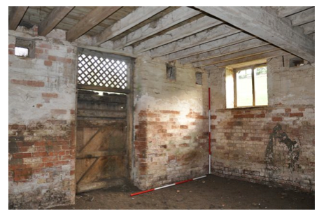
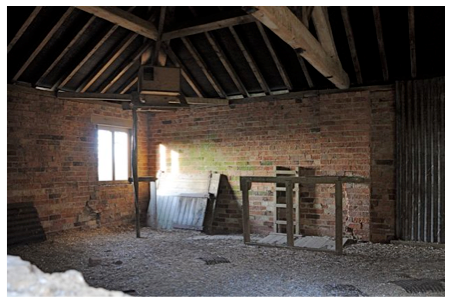
Fig. 23 Feed store, ground floor looking east Fig. 24 Feed store, first floor looking west with owl-box
v) The Milking Parlour
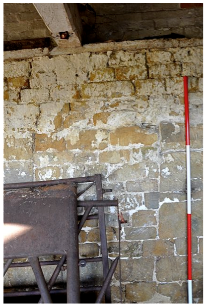
This occupies a further wing running south west from the feed store and completing the ‘L’ shaped arrangement of covered structures and is 15 metres long by 5 metres wide (Fig. 4) . The south-east exterior wall is of well dressed large ironstone blocks carefully coursed and set in a pinkish lime mortar with shelly inclusions. The wall now stands around 1.5 metres above ground level but there is considerable material accumulated against this side of the building, possibly from some additional demolished structure Fig. 25). The whole length appears to be of one build, however, there are two blocked doorways evident. The northern most is closed with stone which matches closely the rest of the wall and but uses different mortar. The second opening is blocked in brick and from the inside this appears to have been done in two stages, initially narrowing the opening before sealing it altogether.
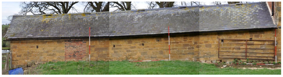
Fig. 25 The Milking parlour, exterior of south-east wall non-rectified mosaic photograph
The south-west gable end wall is in stone with a large two light unglazed window opening just below the eaves (Fig. 26).
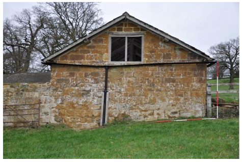
Fig. 26 The milking parlour, south-west gable end
The north-east wall is of brick. It seems originally to have had five doorways at roughly 3 metre centres. The southern most is still used as a doorway and the westernmost is posited but has been totally removed by the insertion of a modern double width doorway under a concrete lintel. The remaining three doorways have been partially blocked with reused bricks and timber framed windows added. These are of four lights with the upper two opening upwards. They appear to be of twentieth century manufacture (Fig. 27).
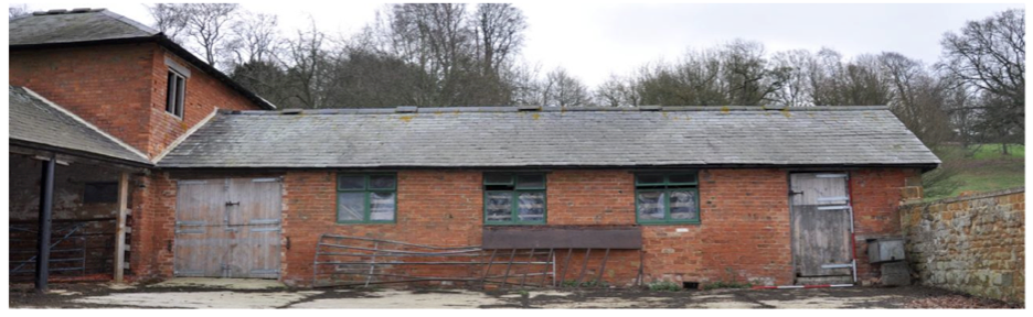
Fig. 27 The Milking parlour, exterior of south-east wall
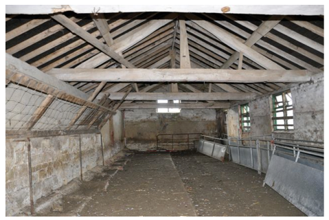
Fig. 28 Milking Parlour looking south west
The ground floor was formerly divided into two bays by a brick wall but an additional concrete block work wall has been constructed to create a small square room in the southern corner. There is a recess indicating a blocked doorway which gave access to the milking parlour but this has been replaced by a double width modern opening under a concrete lintel. Access to the first floor was by a vertical timber ladder, now boarded over, on the south-west wall which lead up to a timber hatch. Opportunities to examine the first floor in detail were curtailed by concerns about the soundness of the timber floor which is carried on two massive beams running from north-west to south-east and the presence of a tenanted owl-box. However, apart from a railing adjacent to the hatch there were no other internal fittings. The roof appeared to be of machine sawn softwood with a single asymmetrically placed bolted queen post truss with braces and straining beam.
Fig. 23 Feed store, ground floor looking east Fig. 24 Feed store, first floor looking west with owl-box
v) The Milking Parlour
This occupies a further wing running south west from the feed store and completing the ‘L’ shaped arrangement of covered structures and is 15 metres long by 5 metres wide (Fig. 4) . The south-east exterior wall is of well dressed large ironstone blocks carefully coursed and set in a pinkish lime mortar with shelly inclusions. The wall now stands around 1.5 metres above ground level but there is considerable material accumulated against this side of the building, possibly from some additional demolished structure Fig. 25). The whole length appears to be of one build, however, there are two blocked doorways evident. The northern most is closed with stone which matches closely the rest of the wall and but uses different mortar. The second opening is blocked in brick and from the inside this appears to have been done in two stages, initially narrowing the opening before sealing it altogether.
Fig. 25 The Milking parlour, exterior of south-east wall non-rectified mosaic photograph
The south-west gable end wall is in stone with a large two light unglazed window opening just below the eaves (Fig. 26).
Fig. 26 The milking parlour, south-west gable end
The north-east wall is of brick. It seems originally to have had five doorways at roughly 3 metre centres. The southern most is still used as a doorway and the westernmost is posited but has been totally removed by the insertion of a modern double width doorway under a concrete lintel. The remaining three doorways have been partially blocked with reused bricks and timber framed windows added. These are of four lights with the upper two opening upwards. They appear to be of twentieth century manufacture (Fig. 27).
Fig. 27 The Milking parlour, exterior of south-east wall
The
roof timbers are very similar in materials, style and construction to
those already described above the livestock shelter (Fig. 28). In this
case however they show no evidence of wholesale reconstruction. There
are a number of carpenters marks on the tie beams which match the marks
on the principal rafters. There are four king post trusses in oak with
raking struts which span across the full width of the parlour. The form
of the king posts in particular echo the shape of those in the shelter.
The purlins rest of the upper surfaces of the principal rafters and
like the common rafters appear to be modern sawn softwood.
Fig. 28 Milking Parlour looking south west
Fig. 29 Milking parlour, places for two cows against the south-east wall
vi) The Stockyard
Lying to the west of the buildings already described the stockyard is enclosed on the north-west and south-west sides by a stone wall between 1 and 1.5 metres high and constructed from a variety of stones ranging from rough rubble to scattered ashlar blocks. It is capped by flat stone slabs. The north-west wall does not lie in a straight line with the end of the shelter but returns at an angle of around 20 degrees, presumably because of the lie of the land, to create a trapezoidal enclosure (Fig. 4). There is a modern farm gate towards the middle of the south-west side (Fig. 30). The presence of two straight joints towards the north end of the north-west wall indicate a former entrance, an assumption backed up by the remains of a brick path and retaining wall which curves around towards the north-west end of the livestock shelter (Fig. 31). The present surface of the yard is ridged concrete with a fall to the north-west of 5 degrees to facilitate run off. There are two brick lined drains towards the middle of the north-west wall.
Fig. 30 Stockyard looking west Fig. 31 Remains of wall and brick paving north-west of shelter
Section 6 – Discussion and Analysis
i) Usage
Despite the many alterations it has been subject to it is clear that this complex of buildings has always been about the housing of cattle and in particular their care during the winter months. This care is expressed through three different systems of management all of which are evident within the structures. Brunskill sums up the strategies this way, ‘ Cattle were kept loose in yards which were open or partially covered; they were kept loose in small cattle boxes or they were kept tied in cow-houses’ (Brunskill 1982: 60). In simple terms bullocks and beef cattle were kept in the stockyard, sick cattle or cows about to calve would be kept in a loose box, sometimes called a hammel, and milk cattle were tethered in the cow-house. Typically in the late eighteenth and nineteenth centuries cattle were fed over the winter by a combination of hay, root crops and prepared ‘cattle-cake’ all of which was most conveniently stored at first floor level. Finally larger units sometimes made provision for the needs of the staff working with the cattle by setting aside a room to store equipment and materials perhaps with a desk or table where some record keeping could be done. All of these elements are present in the Dairy .
ii) Historical Development
Apart from the fact that development of the site seems to have begun post 1772 we have no fixed dates within the sequence of building and so have to create a floating chronology based on the principles of stratigraphy.
Despite their evident differences we have to assume that the well made dressed stone walls along the north-east and south-east sides of the site are the earliest constructions, however, the differences that exist in mortar and walling suggest they were not of a single build (Fig. 32). The erection of the feed store has eliminated any information about how these two structures were related but we may speculate on the basis of the extremely fine white lime mortar and the unusual quality of at least some of the stonework that the livestock shelter was built first. The fine quality of the stonework and the thin joints in white lime mortar argue that at least at the outset the intention was to build something designed either to be appealing visually or else reflect the high status of the structure. None of this makes much sense on terms of a cattle shed but of course the building is in a very prominent position within the park. Initial instructions could have gone out to the effect that a well made product was looked for. Whatever the case the quality of the work soon tailed off, possibly the supervising mason was called away and the work left to less skilled operators or possibly there was a shift in funding and the money was simply not available to carry on with a high standard of workmanship. Whatever the case having the best quality stonework on the whole estate, and this includes the hall, on the end of the cow-house is anomalous. Equally puzzling is the offset with coursing above rising to an even steeper angle (Fig. 12). This suggests that work was completed on at least the western most part of the building when the decision was taken progressively raise the eaves line. This seems to be further evidence of some additional problem with the structure if not growing incompetence.
Fig. 32 Possible reconstruction of the earliest phases of the dairy using Google SketchUp.
Judging by the structural remains and parallels with other buildings in the locality this would have been a single storey open-sided structure under a conventionally pitched roof with tethering points and feeding places for 10 to 12 cattle. Sockets for the associated timberwork are scattered across the long wall’s inner face but the exact arrangement is hard to make out because of subsequent remodellings, however, a cow-house on the far side of Stanborough Meadow retains enough of its internal ittings to indicate a possible arrangement (Fig. 33). The windows are grouped so as to illuminate and ventilate a double stall and this may well have been the case with this early phase of the livestock shelter. In bad weather the openings were probably closed by shutters, examples of which survive in a cow-house just outside the estate on the Mollington Road (fig. 34). Brunskill makes much of the way in which arrangements for feeding cattle influenced the planning of cow-houses (Brunskill 1982: 61).
Fig. 33 Stanborough Meadow cow-house. Manger and tethering points Fig. 34 Shutter on nineteenth century cow-house, N of Mollington Road
Essentially
cattle could be fed by approaching from behind or via a feeding passage
at the head end. Clearly the latter was the preferred option and it
seems likely that the generous size of these windows and their position
serving a single pair of cattle could have facilitated feeding at the
head end but from outside the building. The blocking of openings in
this wall occur in three stages. It appears likely that the first
closure was to convert the door into a window presumably to accommodate
additional animals. Subsequently this and the two windows to the east
were lowered with the insertion of a timber lintel and brickwork
above and finally all window openings were blocked. It is tempting to
associate this final stage with the point at which the structure ceased
to function as a cow-house with tethered beasts and became a simple
shelter at the end of the yard. The windows would no longer be needed
and blocking them would have done something to reduce wind-chill.
What is less clear is how all this related to the raising of the exterior wall and the remodelling of the roof. As the practice was to not clear out the accumulated manure until the following spring it was often the case that headroom would become restricted. As Brunskill reports, ‘Many farming districts have legends about young cattle kept all winter indoors until they could scarcely squeeze between the manure level and the door head’ (Brunskill 1982: 73). One could speculate that the raising of headroom adjacent to the wall was an attempt to alleviate this problem. Equally it may reflect a change in practice. If the decision was made to block the windows and deliver the food from the rear additional headroom for the workers could have been appreciated. It could also reflect a change to the system used latterly in the milking parlour where a high level manager for hay was accompanied by a low level trough for cattle-cake. This would arguably require a greater height of wall. These efforts to ensure better head room above the feed area could of course been effected in two stages. Initially the roof could have been converted into its asymmetric form with the eaves resting on top of the stone walling then at a later date the addition of the brick topping enables new common rafters to be inserted at a higher level (Fig. 35)
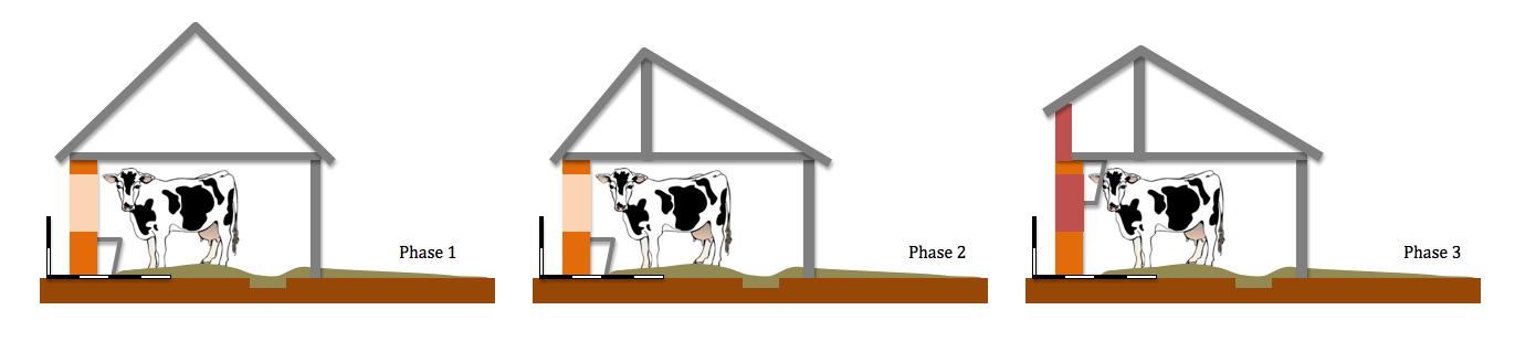
Fig. 35 Possible three phase adaptation of roof
The lean-to built against then outside face of wall (Fig. 13) clearly post dates the lifting of the eaves by the insertion of additional courses of brick work. Map evidence shows it was in place by 1886 but had been demolished sometime between 1922 and 1974. A few rotted timbers remain lying against the foot of the wall but the disturbed nature of the ground indicates that a certain amount of tipping has occurred along this side of the dairy obscuring the original floor surface and any possible pad stones for the posts. The structure must have been reasonably substantial to have counted as part of the dairying work as the wall was whitewashed repeatedly although there is no trace of this practice on the north-west wall of the feed store which would have formed the end wall of the structure.
As already noted the milking parlour may well be broadly contemporaneous with the livestock shelter. As well as the nature of the walling the roof construction is also, in terms of materials and techniques, very similar to that of the shelter. Later modifications have swept away any original fittings but one could speculate that it was also an open-sided structure (Fig. 32) and given the lack of windows may not initially have been used for tethered cattle. Whatever the case, like the shelter, it was partially demolished to accommodate the next phase of building, the two storey loose box and feed store. The use of machine sawed softwood in the roof timbers and other constructional details suggest a later date for this. It is tempting to try relate the arrival of such a large quantity of bricks on site to other work in brick but the character of the bricks and the nature of the mortar clearly delineate three different phases for the feed store, the raising of the shelter wall and the replacement of the open side of the milking parlour with a brick wall. The junction between the latter and the feed store has been destroyed by the insertion of a modern double width doorway whilst there is a straight join at the point where the feed store intersects with the livestock shelter on the outside examination of the inside face reveals a partial rebuild using bricks bonded into the feed store wall indicating that the eaves lifting was an earlier operation (Fig. 36).
Subsequent modifications to the feed store included the insertion of a concrete block wall to partition off a small room. The creation of this space would initially appear to be a mid- to late-twentieth century improvement but it is worth considering the implications of the way in which this space is lit. The window is the only one which was definitely glazed. Looking at the details of the hinges and fastenings in a domestic context this window would be assigned to the late eighteenth century, possibly the early nineteenth (Wood-Jones 1963: 255 66). Could it have been reused from a cottage on the estate? Whatever the case it seems likely that this room was set aside for the use of those working at the Dairy at an early stage and so perhaps the block work replaced a decayed timber partition. The existing internal timber door set into the modern wall certainly appears to be much earlier. This room could possibly have functioned as a combined office and store (Fig. 37).
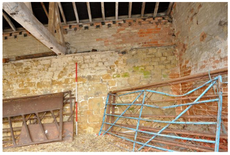
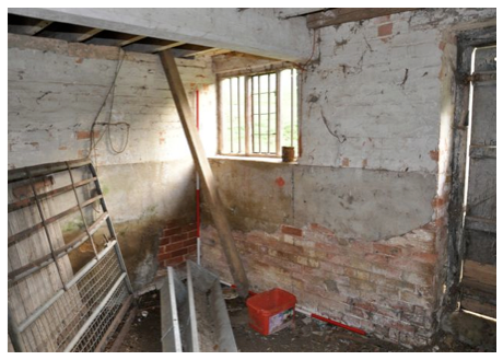
Fig 36 Junction between the feed store and livestock shelter showing partial rebuild of the internal wall looking east.
Fig. 37 Feed store, ground floor room looking east
What is less clear is how all this related to the raising of the exterior wall and the remodelling of the roof. As the practice was to not clear out the accumulated manure until the following spring it was often the case that headroom would become restricted. As Brunskill reports, ‘Many farming districts have legends about young cattle kept all winter indoors until they could scarcely squeeze between the manure level and the door head’ (Brunskill 1982: 73). One could speculate that the raising of headroom adjacent to the wall was an attempt to alleviate this problem. Equally it may reflect a change in practice. If the decision was made to block the windows and deliver the food from the rear additional headroom for the workers could have been appreciated. It could also reflect a change to the system used latterly in the milking parlour where a high level manager for hay was accompanied by a low level trough for cattle-cake. This would arguably require a greater height of wall. These efforts to ensure better head room above the feed area could of course been effected in two stages. Initially the roof could have been converted into its asymmetric form with the eaves resting on top of the stone walling then at a later date the addition of the brick topping enables new common rafters to be inserted at a higher level (Fig. 35)
Fig. 35 Possible three phase adaptation of roof
The lean-to built against then outside face of wall (Fig. 13) clearly post dates the lifting of the eaves by the insertion of additional courses of brick work. Map evidence shows it was in place by 1886 but had been demolished sometime between 1922 and 1974. A few rotted timbers remain lying against the foot of the wall but the disturbed nature of the ground indicates that a certain amount of tipping has occurred along this side of the dairy obscuring the original floor surface and any possible pad stones for the posts. The structure must have been reasonably substantial to have counted as part of the dairying work as the wall was whitewashed repeatedly although there is no trace of this practice on the north-west wall of the feed store which would have formed the end wall of the structure.
As already noted the milking parlour may well be broadly contemporaneous with the livestock shelter. As well as the nature of the walling the roof construction is also, in terms of materials and techniques, very similar to that of the shelter. Later modifications have swept away any original fittings but one could speculate that it was also an open-sided structure (Fig. 32) and given the lack of windows may not initially have been used for tethered cattle. Whatever the case, like the shelter, it was partially demolished to accommodate the next phase of building, the two storey loose box and feed store. The use of machine sawed softwood in the roof timbers and other constructional details suggest a later date for this. It is tempting to try relate the arrival of such a large quantity of bricks on site to other work in brick but the character of the bricks and the nature of the mortar clearly delineate three different phases for the feed store, the raising of the shelter wall and the replacement of the open side of the milking parlour with a brick wall. The junction between the latter and the feed store has been destroyed by the insertion of a modern double width doorway whilst there is a straight join at the point where the feed store intersects with the livestock shelter on the outside examination of the inside face reveals a partial rebuild using bricks bonded into the feed store wall indicating that the eaves lifting was an earlier operation (Fig. 36).
Subsequent modifications to the feed store included the insertion of a concrete block wall to partition off a small room. The creation of this space would initially appear to be a mid- to late-twentieth century improvement but it is worth considering the implications of the way in which this space is lit. The window is the only one which was definitely glazed. Looking at the details of the hinges and fastenings in a domestic context this window would be assigned to the late eighteenth century, possibly the early nineteenth (Wood-Jones 1963: 255 66). Could it have been reused from a cottage on the estate? Whatever the case it seems likely that this room was set aside for the use of those working at the Dairy at an early stage and so perhaps the block work replaced a decayed timber partition. The existing internal timber door set into the modern wall certainly appears to be much earlier. This room could possibly have functioned as a combined office and store (Fig. 37).
Fig 36 Junction between the feed store and livestock shelter showing partial rebuild of the internal wall looking east.
Fig. 37 Feed store, ground floor room looking east
Developments
in the milking parlour included the insertion of a brick wall
partially closing it off from the stockyard. We suggested that on the
basis of blocked openings this wall initially had five openings onto
the yard. Whether these were closed with timber doors or not the
arrangement seems a curious one and at a later period, presumably well
into the twentieth century, the three central openings were partially
closed with reused bricks and timber framed wired glass windows added.
This work may well have been undertaken at the same time as the parlour
was given its final modifications to enable it to be used for
tethering and milking cows (Figs. 38 and 39).
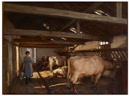
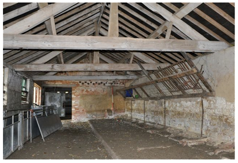
Fig 38 Early 20th. century cow-shed (Enwall 1922) Fig 39 The north-east end of the milking parlour looking north
These measures included the laying of a concrete floor with dung drain and the addition of feeding troughs, stanchions for tethering and a high level manger. The lack of electricity and piped water clearly limited its potential for modern milk production and as already noted the Dairy seems to have gone out of use in the decade before the National Trust took over in 1960. Since then some work has been undertaken. All parts of the structure were reroofed, possibly sometime in the 80s. The original slates were reused but many new rafters were inserted as was roofing felt. In addition some repointing was done on the north-west face of the feed store. Intriguingly the stone work closing the blocked windows to the livestock shelter have modern Portland cement based mortar. Could this be over-zealous repointing or were the effects of brick blocking softened by cladding it with twentieth century stone? The stockyard was resurfaced with concrete also probably in the 80s.
Possibly the key period of development within the park was between 1815 and 1820 when considerable improvements were effected under the direction of Henry Hakewell. Indeed English heritage ascribe the building of the Dairy to this period (English Heritage 2012). However, examination of his work on the walled garden tends to suggest that the feed store is in many ways typical of his additions to the estate. If this is the case the multi-phase development of the earlier structures must have occupied a reasonable period of time so one could argue for the initial stone construction to be perhaps late eighteenth century with the feed store arriving early in the nineteenth century and subsequent developments continuing into the first half of the twentieth century (Fig. 40).
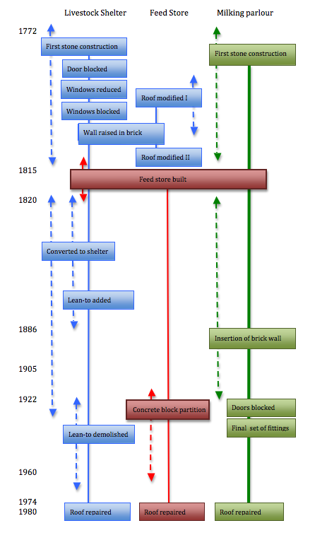
Fig. 40 Outline stratigraphic matrix for the Dairy
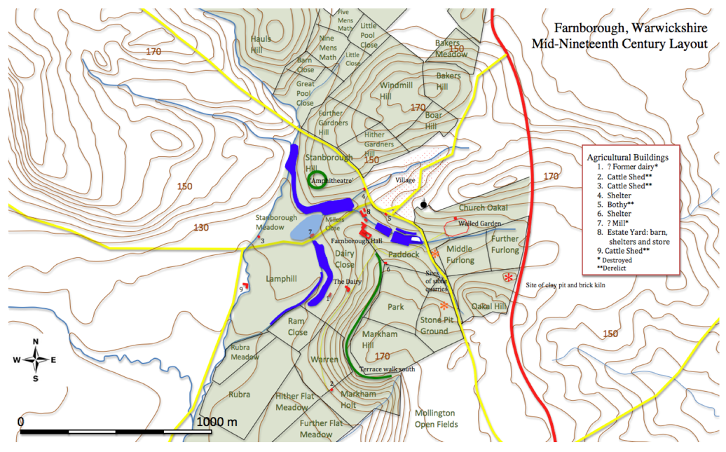
Fig. 41 The estate in the nineteenth century with locations of agricultural buildings
iii) Comments
In 1772 the Farnborough estate had just over 200 acres of pasture (Linnell 1772). Allowing for up to 30 cows per 100 acres (Fussell 1966 :7) this suggests a herd between 50 and 60 strong. Three additional cattle shelters have been examined in the area (Fig. 41) with a total capacity for 32 tethered cows and a flexible number held in adjoining stockyards. This indicates something of the importance of cattle to the economy of the estate. Although cattle husbandry seems to be an unchanging element of the country scene Valenza reminds us that, ‘Against the erratic practices of traditional husbandry, new agriculture posed technique that was observed, recorded and repeated in the best empirical style’ (Valenza 1991: 152). It seems clear that the repeated modifications and alterations to the dairy was the concrete expression of this drive to improve. Given, therefore the highly visible situation within the most ornamental part of the park it seems that by the late eighteenth century utility was enough. There is no pretence that these buildings are classical temples as is the case with the game larder of c. 1740 (Fig. 42). The sole concessions to the site’s aesthetic potential is the use of well made stone walls in the earliest phase, a practice repeated with the two walls facing the
hall and terrace when the two storey feed store was erected. In fact at some point in the early nineteenth century a stand of sweet chestnuts was planted to the north–east of the Dairy thereby reinstating an element of the earlier planting and offering both shelter and a degree of obscurity to the Dairy. Now that practices in agriculture have changed so radically it seems that that obscurity is now doomed to lapse into ruin. Despite repairs towards the end of the twentieth century unused agricultural buildings are becoming derelict, some have collapsed others have been subject to controlled demolition and recording (Milln 2011) as is the case with the cow house in Markham Holt (Fig. 43). Whilst the dairy remains in reasonably good condition and is occasionally used its long term future seems less than secure. Many similar buildings on National Trust property are converted into cafes or gift shops or garden centres. The low visitor profile and the distant location make such a conversion unlikely so we can only hope that priorities will change and this building will be valued for its own sake as a minor monument to an important aspect of British farming.
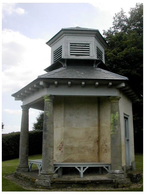
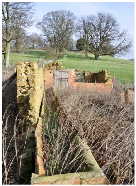
Fig. 42 The game larder probably designed by Sanderson Miller Fig. 43 Remains of cow house at Markham Holt
Bibliography
English Heritage 2011. Farnborough Hall, Banbury, England, Record Id: 1304 Register of Parks and Gardens of Special Historic Interest, http://www.parksandgardens.ac.uk/component/option,com_parksandgardens/task,site/id,1304/tab,history/Itemid,305/
accessed 14.12.2011
Enwall, F.W. 1922 Painting of cowshed – Wilson’s Mill near Beverley East Riding of Yorkshire Museum Service (BAG) 1997.2
Fussell, G.E. 1966 The English Dairy Farmer 1500 - 1900 London: Frank Cass and Co. Ltd.
Holbech, G. (Undated) Hand drawn plan of nineteenth century layout of house and service block
Jenkins, J.G. 1978 Traditional Country Craftsmen London: Routledge and Kegan Paul
Linnell, E. 1772. Farnborough Estate Survey, Warwickshire County Records Office Ref. z 403 (u)
Meir, J. 1997. Sanderson Miller and the landscaping of Wroxton Abbey, Farnborough Hall and Honnington Hall Garden History, Volume 25 number 1 pages 81 – 106
Meir, J. 2002 Development of a Natural Style in Designed Landscapes between 1730 and 1750: the English Midlands and the Work of Sanderson Miller and Lancelot Brown Garden History, Volume 30 number 1 pages 24 - 48
Meir, J. 2006. Sanderson Miller and his Landscapes, Chichester: Phillimore
Valenza, D. 1991 The Art of Women and the Business of Men: Women’s Work and the Dairy Industry c. 1740 – 1840 Past and Present Number 130
Wass, S. 2011 The Farnborough Park Project http://www.polyolbion.org.uk/Farnborough/Project.html
Williamson, T. 2007. Archaeological Perspectives on Estate Landscapes: Research Agendas Design, Improvement and Power in the Post-Medieval landscape Woodbridge: Boydell and Brewer
Wood-Jones, R.B. 1963 Traditional Domestic Architecture of the Banbury Region, Manchester: Manchester University Press
Fig 38 Early 20th. century cow-shed (Enwall 1922) Fig 39 The north-east end of the milking parlour looking north
These measures included the laying of a concrete floor with dung drain and the addition of feeding troughs, stanchions for tethering and a high level manger. The lack of electricity and piped water clearly limited its potential for modern milk production and as already noted the Dairy seems to have gone out of use in the decade before the National Trust took over in 1960. Since then some work has been undertaken. All parts of the structure were reroofed, possibly sometime in the 80s. The original slates were reused but many new rafters were inserted as was roofing felt. In addition some repointing was done on the north-west face of the feed store. Intriguingly the stone work closing the blocked windows to the livestock shelter have modern Portland cement based mortar. Could this be over-zealous repointing or were the effects of brick blocking softened by cladding it with twentieth century stone? The stockyard was resurfaced with concrete also probably in the 80s.
Possibly the key period of development within the park was between 1815 and 1820 when considerable improvements were effected under the direction of Henry Hakewell. Indeed English heritage ascribe the building of the Dairy to this period (English Heritage 2012). However, examination of his work on the walled garden tends to suggest that the feed store is in many ways typical of his additions to the estate. If this is the case the multi-phase development of the earlier structures must have occupied a reasonable period of time so one could argue for the initial stone construction to be perhaps late eighteenth century with the feed store arriving early in the nineteenth century and subsequent developments continuing into the first half of the twentieth century (Fig. 40).
Fig. 40 Outline stratigraphic matrix for the Dairy
Fig. 41 The estate in the nineteenth century with locations of agricultural buildings
iii) Comments
In 1772 the Farnborough estate had just over 200 acres of pasture (Linnell 1772). Allowing for up to 30 cows per 100 acres (Fussell 1966 :7) this suggests a herd between 50 and 60 strong. Three additional cattle shelters have been examined in the area (Fig. 41) with a total capacity for 32 tethered cows and a flexible number held in adjoining stockyards. This indicates something of the importance of cattle to the economy of the estate. Although cattle husbandry seems to be an unchanging element of the country scene Valenza reminds us that, ‘Against the erratic practices of traditional husbandry, new agriculture posed technique that was observed, recorded and repeated in the best empirical style’ (Valenza 1991: 152). It seems clear that the repeated modifications and alterations to the dairy was the concrete expression of this drive to improve. Given, therefore the highly visible situation within the most ornamental part of the park it seems that by the late eighteenth century utility was enough. There is no pretence that these buildings are classical temples as is the case with the game larder of c. 1740 (Fig. 42). The sole concessions to the site’s aesthetic potential is the use of well made stone walls in the earliest phase, a practice repeated with the two walls facing the
hall and terrace when the two storey feed store was erected. In fact at some point in the early nineteenth century a stand of sweet chestnuts was planted to the north–east of the Dairy thereby reinstating an element of the earlier planting and offering both shelter and a degree of obscurity to the Dairy. Now that practices in agriculture have changed so radically it seems that that obscurity is now doomed to lapse into ruin. Despite repairs towards the end of the twentieth century unused agricultural buildings are becoming derelict, some have collapsed others have been subject to controlled demolition and recording (Milln 2011) as is the case with the cow house in Markham Holt (Fig. 43). Whilst the dairy remains in reasonably good condition and is occasionally used its long term future seems less than secure. Many similar buildings on National Trust property are converted into cafes or gift shops or garden centres. The low visitor profile and the distant location make such a conversion unlikely so we can only hope that priorities will change and this building will be valued for its own sake as a minor monument to an important aspect of British farming.
Fig. 42 The game larder probably designed by Sanderson Miller Fig. 43 Remains of cow house at Markham Holt
Bibliography
English Heritage 2011. Farnborough Hall, Banbury, England, Record Id: 1304 Register of Parks and Gardens of Special Historic Interest, http://www.parksandgardens.ac.uk/component/option,com_parksandgardens/task,site/id,1304/tab,history/Itemid,305/
accessed 14.12.2011
Enwall, F.W. 1922 Painting of cowshed – Wilson’s Mill near Beverley East Riding of Yorkshire Museum Service (BAG) 1997.2
Fussell, G.E. 1966 The English Dairy Farmer 1500 - 1900 London: Frank Cass and Co. Ltd.
Holbech, G. (Undated) Hand drawn plan of nineteenth century layout of house and service block
Jenkins, J.G. 1978 Traditional Country Craftsmen London: Routledge and Kegan Paul
Linnell, E. 1772. Farnborough Estate Survey, Warwickshire County Records Office Ref. z 403 (u)
Meir, J. 1997. Sanderson Miller and the landscaping of Wroxton Abbey, Farnborough Hall and Honnington Hall Garden History, Volume 25 number 1 pages 81 – 106
Meir, J. 2002 Development of a Natural Style in Designed Landscapes between 1730 and 1750: the English Midlands and the Work of Sanderson Miller and Lancelot Brown Garden History, Volume 30 number 1 pages 24 - 48
Meir, J. 2006. Sanderson Miller and his Landscapes, Chichester: Phillimore
Valenza, D. 1991 The Art of Women and the Business of Men: Women’s Work and the Dairy Industry c. 1740 – 1840 Past and Present Number 130
Wass, S. 2011 The Farnborough Park Project http://www.polyolbion.org.uk/Farnborough/Project.html
Williamson, T. 2007. Archaeological Perspectives on Estate Landscapes: Research Agendas Design, Improvement and Power in the Post-Medieval landscape Woodbridge: Boydell and Brewer
Wood-Jones, R.B. 1963 Traditional Domestic Architecture of the Banbury Region, Manchester: Manchester University Press