August / September 2011
Back to Project Contents and Introduction
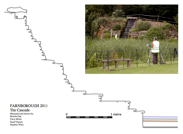
The
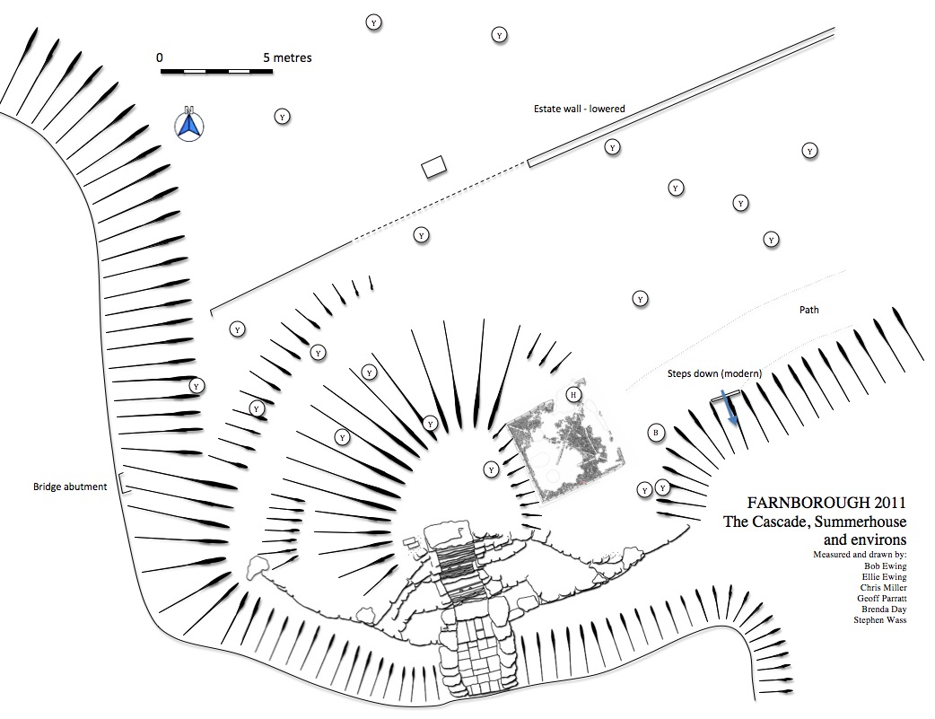
recording of the cascade continued through August. Building on the plan
(see above) we also undertook a stone by stone elevation drawing
of the stonework which, given the many different planes the
monument has been constructed in, proved a challenging task. Work
was
also completed on planning the immediate environs of the cascade (see
below) and trying to develop something of an understanding of how the
cascade was actually experienced by 'users' in the eighteenth and
nineteenth centuries. We have also planned the line of what we assume is the
eighteenth century estate wall which was systematically lowered to
create an edging to the planting when the road was diverted in the
nineteenth century. Surface indications suggest the possibility of an
entrance to the north of the cascade.
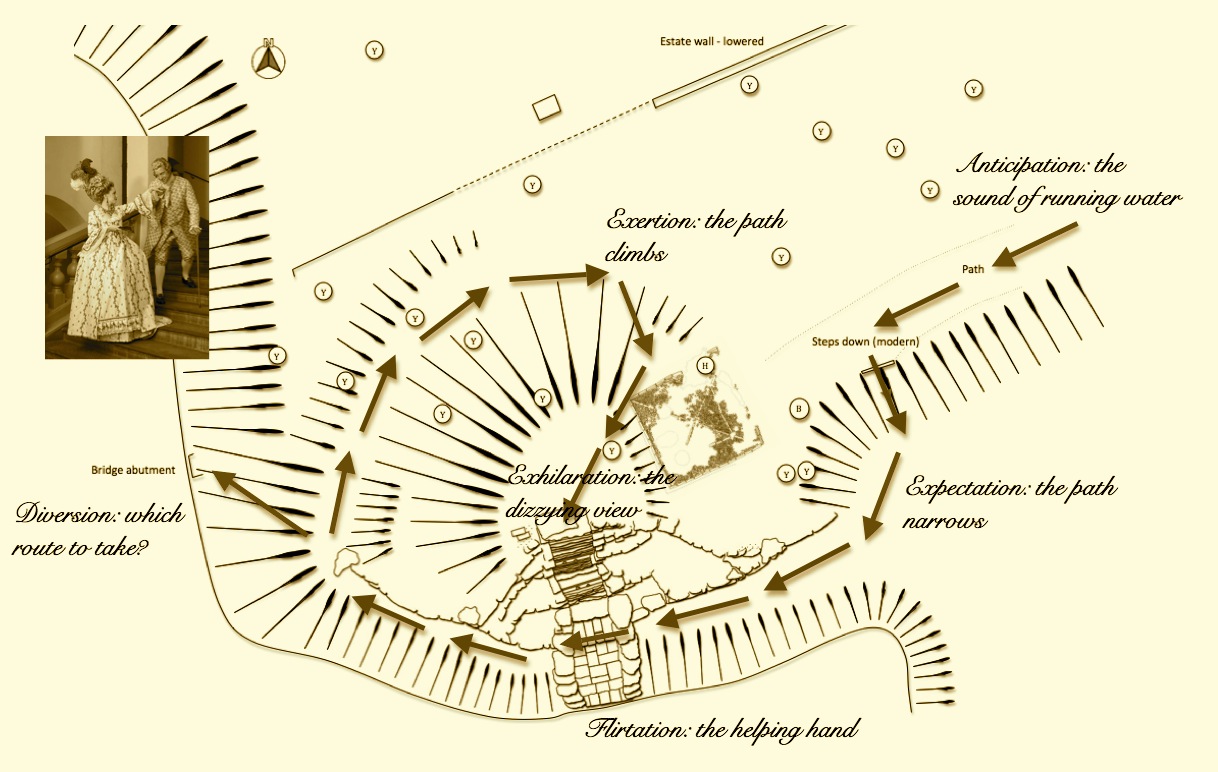
As
well as recording the materiality of the garden features and attempting
to understand the technology of their construction and use we are also
interested in how the various garden features were experienced by the
owners of and visitors to the park. We know for example from Sanderson
Miller's diaries that it was a common practice to take extended walks
around these parks that sometimes occupied several hours. One has to
ask what sorts of experiences were afforded by the cascade and although
there are great dangers in assuming that people in the past were 'just
like us' it is also valid to use one's own experiences to reflect on
how others perceived and used the site. As a contemporary user two
things stand out: the crossing of the lower reaches of the cascade and
the view from the capstone looking down the cascade. The lower steps of
the cascade are beautifully paved, a feature which certainly cannot be
appreciated from a distant view and which cries out to be crossed. Given the apparent line of
approach via a terrace in front of the cascade which then appears to
spiral up behind the mound to emerge at the top one could
speculate on a series of events something like those sketched out,
albeit a little light-heartedly, below. The key elements in this
analysis is the feeling that the cascade was meant to be crossed at
this point - there is some evidence of an iron handrail - and that for
those approaching the top of the mound the impetus to stand on top of
the capstone and look down would be irresistible. I know we are out on
a bit of a limb here but I feel sure that there was more to using the
cascade that just looking at it from afar.
Another
intriguing feature which emerged from the undergrowth was a pair of
brick pillars set either side of the channel to the west of the
cascade. These have the appearance of being abutments for a footbridge
- a function now conveniently carried out by a fallen tree. It was
extremely satisfying to hear from a member of the audience at the talk
given on August 27th. in the village hall that she remembered crossing a
wooden bridge at this point which was a dangerous undertaking as many
of the slats were rotten or missing. This would have been at some time
around the middle of the last century.
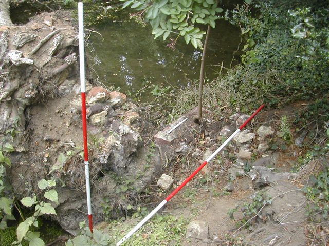
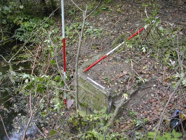
East bridge abutment looking north-west West bridge abutment looking south-west
Section through the cascade with a couple of team surveying the base
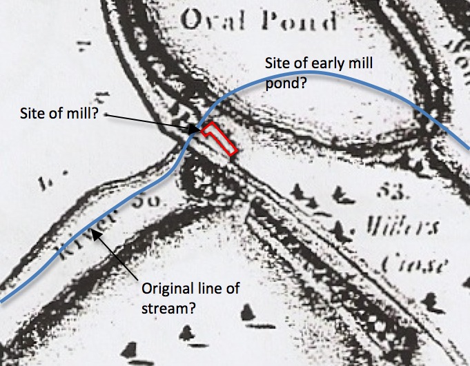
One
of the themes of our investigations is to gain a better understanding
of how water was used in and around the park and to that end we are
always keen to identify the sites of earlier features, particularly
mills. It seems likely that there was a mill in the area of the cascade
as evidenced by oral testimony and the fact that the adjacent plot of
land is named Millers Close. Having spent a lot of time examining the
stone work of the cascade and the topography of the immediate area I
can find no evidence that the structure as it stands is an eighteenth
century reuse of an earlier mill building, however, when I came to
examine the 1771 estate map in an enlarged version it became clear that
an 'L' shaped building stood on the other side of the road. Given its
relation to the general flow of water could this be an earlier mill now
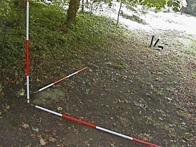
demolished? What was particularly pleasing was to be able to wander over to the
site and having brushed away the fallen leaves discover some
significant blocks of stone poking out from the ground. Having explored
the roadside for several metres in either direction it is clear that
these blocks only occur at the point at which the building is shown on
the plan so here is another site which could benefit from further
investigation.
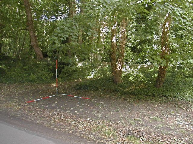
Site of building from the eighteenth century estate map: from the south and from the west
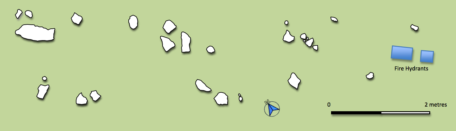
Plan of stones on the site of building from the eighteenth century estate map
In September we undertook a photographic expedition to enable Chris Mitchell to assemble a marvelous portfolio of images from around the park - you can read his blog about the experience here . Also, thanks
to the assistance of David Jones of Farnborough - a very experienced
arborculturalist - we have been able to identify some of the old fruit
varieties in the orchard tucked in to the north west position of the
Paddock.
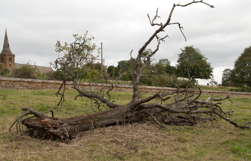
Photo by Chris Mitchell
Photo by Chris Mitchell
You can see what we have discovered here.
The kind of work we are doing here is only really of any value if we tell other people about it. Putting things on-line is a start but we also need to see things published in a variety of formats. By way of making a start I made use of some of the material from Farnborough to inform papers written as part of the M.A. programme with the University of Leicester. Many, many thanks to everyone who has helped so far, I could not have done so much without your help. |