By Stephen Wass
Back to Project
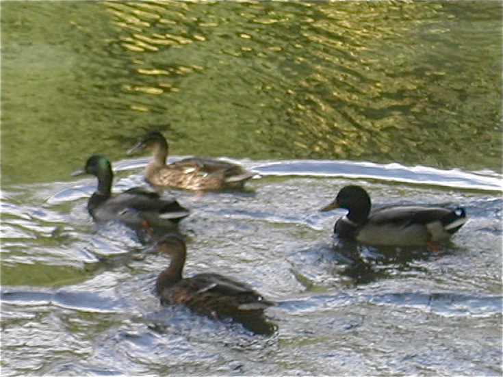
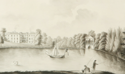
Fig. 1 Ducks on Sourland Pond
Submitted for the degree of Master of Arts, Historical Archaeology
School of Archaeology and Ancient History
University of Leicester
September 2012
ABSTRACT
The park around Farnborough Hall, Warwickshire contains sites and monuments from the early medieval period onwards. Many of these are to do with the use and management of water. This account, mainly based on these remains, adopts an object biographical approach to tell the story of the changing ways in which water resources have been exploited, beginning with an examination of environmental factors, the early history of the park and its creation in the seventeenth century. A detailed account of the development of the Georgian park under the aegis of two individuals: William Holbech, the landowner and Sanderson Miller a gentleman architect, looks at factors which influenced the design of the park, documents a number of surviving structures and examines some of the technical aspects of construction. A number of highly unusual features have been recorded including a garden amphitheatre, a large raised pool and an elongated waterway which shares some characteristics with early river navigations. The consideration of the options available to both the work force and the social elite who shared the park explores the divide between labour and leisure. Debates about legitimation are considered and patterns of use and ownership expressing inequalities of power and social dominance are traced through to the present day.
The park around Farnborough Hall, Warwickshire contains sites and monuments from the early medieval period onwards. Many of these are to do with the use and management of water. This account, mainly based on these remains, adopts an object biographical approach to tell the story of the changing ways in which water resources have been exploited, beginning with an examination of environmental factors, the early history of the park and its creation in the seventeenth century. A detailed account of the development of the Georgian park under the aegis of two individuals: William Holbech, the landowner and Sanderson Miller a gentleman architect, looks at factors which influenced the design of the park, documents a number of surviving structures and examines some of the technical aspects of construction. A number of highly unusual features have been recorded including a garden amphitheatre, a large raised pool and an elongated waterway which shares some characteristics with early river navigations. The consideration of the options available to both the work force and the social elite who shared the park explores the divide between labour and leisure. Debates about legitimation are considered and patterns of use and ownership expressing inequalities of power and social dominance are traced through to the present day.
PREFACE
This study is the culmination of a two year contract with the National Trust to survey and record the archaeological features associated with the eighteenth-century park at Farnborough, Warwickshire. The project has been developed with the assistance of a team of volunteers many of them drawn from local heritage groups. The programme of study has been supported by a number of small scale excavations and documentary research, primarily at the Warwickshire County Record Office, where a copy of the archive will be deposited in addition to the material going to the National Trust.
ACKNOWLEDGEMENTS
Thanks to:
Richard White, gardener at Farnborough and his staff and team of volunteers for continual support both practical and moral;
Hesather Aston and Julie Smith both of the National Trust for oiling wheels
Jeremy Milln, former archaeological advisor to the National Trust for first seeing the potential of this project and to his successor at the Trust, Janine Young, who has supported the work in so many ways;
Professor Timothy Mowl, Dr. Jennifer Meir and Diane James M.A. for discussing aspects of the work with me;
the many villagers who have expressed interest in and support for the work;
the indefatigable team of volunteers including Peter Braybrook, Stephen and Brenda Day, Bob Ewing, Chris and Linda Leslie, Bryan Martin, Chris Miller, Geoff Parratt, Samuel Phipps, Isobel and Naomi Smith, Kathryn Stone, Verna Wass and Joseph Wass.
... and, of course, thanks to the Holbech family for everything else...
CONTENTS
Chapter 1 Introduction
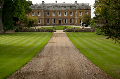
Fig. 2 Farnborough Hall, north front c. 1750. (Photo CM).
The landscape around Farnborough Hall, Warwickshire (Fig. 2) is a remarkable one with sites representing periods from the early-medieval onwards. It contains an hitherto unrecognized garden amphitheatre, a very unusual large raised oval pool and an extraordinary artificial river. The richness of this landscape enables a biographical study of water to be undertaken within a closely defined area. The notion of gaining understanding of the materiality of culture through ‘object biographies’ retains its currency more than ten years after the publication of Marshall and Gosden (1999) and the idea continues to be developed (Joy 2009). It is an extension of this concept to adopt a chronological approach, in effect, ‘telling the story’ of the interaction between the water in this landscape and those who used it.
The archaeological study of water is further enlivened by Wittfogel’s (1957) conjecture that the growth of ruling elites is connected to the control of water resources. This has informed the study of large scale hydraulic engineering and irrigation linked to social and geopolitical developments (for example Harrower 2009 or Sulas et al 2009). Microanalyses of the implications for smaller communities are less frequent, with Sayer’s (2009) excavations at Swavesey and Burwell being a notable exception. This project provides an opportunity to examine the use of water resources over an extended period with a particular emphasis on the controlling influence of social and cultural elites.
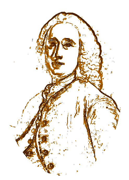
Fig.3 Sanderson Miller
The most revealing episode in the biography of Farnborough’s water occurs in the 1740s when there was an extensive remodeling of the park attributed to the enigmatic figure of amateur architect, Sanderson Miller (Fig. 3) and his patron William Holbech. These personalities of the mid-eighteenth century intersect with our watery flow in a way which is revealing in terms of a better understanding of changing relationships between the uses of water and patterns of power and dominance. There have been many discussions about the relationship between individuals and the arc of history (Trigger 2006: 386 to 480). However, there is a widespread acceptance that significant developments in English landscape design happened as the result of partnerships between wealthy landowners and professional gardeners many of which are well documented (Mowle 2010). What makes the role of archaeology at Farnborough significant is the paucity of written records, a situation which can be partially remedied by a study of surviving monuments.

Fig. 4 Profile scarp and dip slope (see Fig. 5), vertical scale times 2.
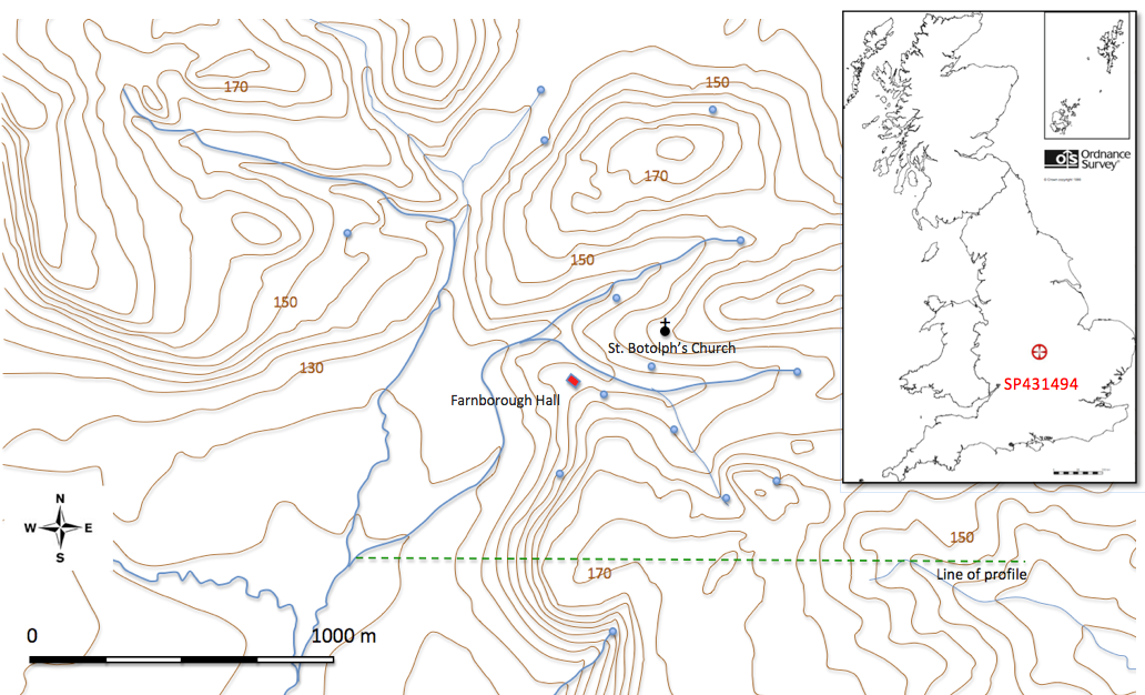
Fig. 5 Farnborough Park, location: contours, springs and streams, from OS 1:25,000 map.
Farnborough lies on a northern outlier of the Cotswolds: a southern tilting mass made up of early Jurassic marine shales, limestones and sands of the lias group. The most prominent part of these deposits is a marlstone bed, which is a calcareous, sandy ironstone and due to its relative hardness, forms an elevated ridge (Williams 1975). Because of this the initial fall of the scarp is quite steep (Fig. 4) with an overall height of around 40 metres. The rusty brown ironstone has been widely used locally for building (Radley 2003: 209).
The scarp, running north-west to south-east, is dissected by a number of streams which come together to the south-west of the hall forming a re-entrant angle of low ground, sheltered by heights to the north and east (Fig. 5). The lower slopes consist of hill-wash and eroded material derived from the underlying marlstone, whilst the flatter plain to the south-east is composed of alluvial deposits of silt, clay and gravel, of periglacial origin.
There are several springs in the area, mainly clustered between the 145 and 160 metre contour. Some of these exist as depressions in the face of the hill-side from which water seeps, whilst others have been given some additional structure as at St. Botolph’s Well (Fig. 9) or the spring in the corner of The Paddock, which was enclosed in an octagonal brick wall (Fig. 21).
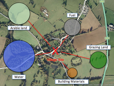
Fig. 6 Natural resources, ’weighted’ according to the likely importance to villagers (after Chisholm 1979:103)
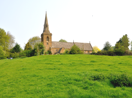
Fig. 7 Church and house platform, from south
Fig. 7 Church and house platform, from south
Farnborough, in its earliest recorded form of Ferneberge, means Fern Hill (Duignan 1912: 56), an appropriate description for a village on a ridge flanked by two marshy valleys (Fig. 5). The location is typical of settlements on the fringes of the upper Cherwell valley such as nearby Mollington and Warmington which may have been founded in the seventh century by groups of immigrants who had spread across central England (Blair 1994: 42). A recent excavation south of the church has uncovered early medieval pottery which could be pre-conquest (Wass 2012b).
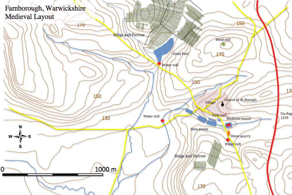
Fig. 8 Medieval settlement.
The settlement was sited to take advantage of the natural resources important to sustain life (Fig. 6). It is indisputable that water was a vital factor in the location of any settlement and not just for utilitarian reasons. Roberts reminds us of the less material factors governing the situation of villages and, given the particular prominence of the church (Fig. 7), one must acknowledge cultural factors at work (Roberts 1987: 106), some of which may give a sacred dimension to the landscape. This links to the matter of water supply given the proximity of the holy well of Saint Botolph (Fig. 9). At Domesday Farnborough was inhabited by eighteen villagers, one small holder and two servi. The manor, held by the Bishop of Chester, passed to the Say family then, in the mid-fourteenth century, to the Raleghs (Salzman 1949: 84). St. Botolph’s church, primarily fourteenth century, has a twelfth-century south door and chancel arch (Pevsner and Wedgwood 1986: 292).
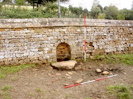
Fig. 9 St. Botolph’s Well, from south-west.
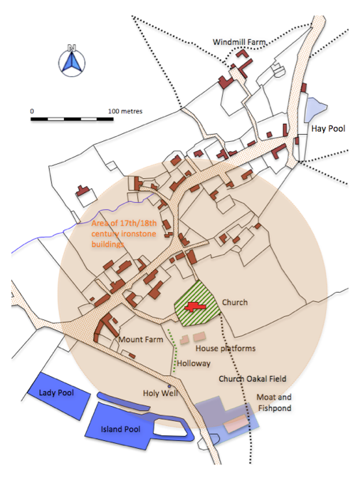
Fig. 10 Outline plan from 1885 OS map
Fig. 10 Outline plan from 1885 OS map
Settlement Remains
The village appears linear in form, but if the nineteenth-century
developments to the north are discounted and the earthworks to the south are factored in, we have a more nuclear plan centred on the church (Fig. 10).The earthworks in Church Oakal field (Fig. 11) had not previously been surveyed in detail. The field occupies the north side and bottom of a shallow valley which lies between two hills; Oakal Hill to the south and Church Hill to the north. Today some of the field is occupied by the remains of the early nineteenth-century walled garden. Church Oakal C site has the remains of some small-scale quarrying.
Church Oakal B Site.
Here four distinct platforms may be identified and interpreted as a farmstead with the main house on the crest of the hill on the western side of the complex (Fig. 7) and a larger building, possibly a barn, to the east and smaller ancillary buildings to the north. Alternatively, there could have been up to four individual dwellings. This area is bounded on the north by the churchyard wall acting as a revetment to the higher ground around the church. The suggestion that these buildings may have been removed to improve the view of the church from the Game Larder (Fig. 71) is confirmed by the discovery of early eighteenth-century pottery in the destruction rubble spread across part of the site (Wass 2012a). To the west of the platform complex is an obvious holloway, which runs down the hillside from a point east of the church to the Banbury road, where it curves round to join the existing roadway. On the other side of the park wall is St. Botolph's Well and it seems likely that the holloway linked the church to the holy well (Fig. 11).
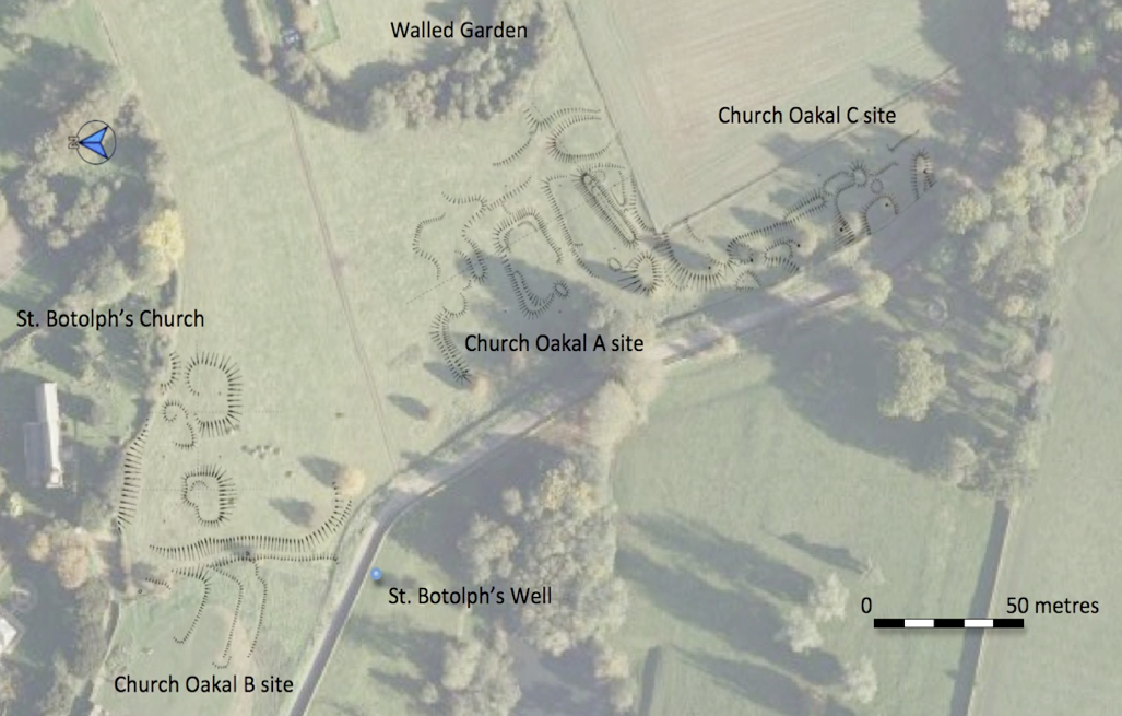
Fig. 11 Earthworks in Church Oakal Field.
Church Oakal A Site
The valley bottom has a series of earthworks in varying states of preservation (Figs. 11 and 12). The most prominent feature is a bank running roughly east-west parallel to and a little upslope from the valley bottom. The bank merges into the valley side at its east end where it is cut by two deep channels. It has been leveled towards its west end and terminates above a marshy area just short of the road. Interpretation is difficult because of the destruction by ploughing of further earthworks in the field to the south. Stone work is eroding out from the southern margin of the bank towards its western end.
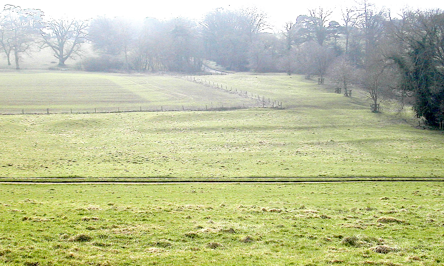
Fig. 12 Church Oakal A site, from north (Photo CM).
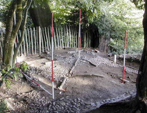
Central to the site is a rectangular platform with a raised rim and a shallow moat. To the north-west the moat broadens out into a low level area marking the site of an attached fishpond. Other banks and terraces suggest the possibility of ancillary structures in what appears to be a typical medieval homestead site, possibly the remains of the manor. Recent excavations uncovered a stone revetment on the south bank of the platform and an internal sleeper wall (Fig. 13) indicating the presence of a timber-framed building associated with late-medieval pottery (Wass 2012b) .
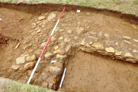
Fig. 13 Church Oakal A site, revetment to moat and sleeper wall, from east (Photo VW).
The Fishponds
Fishponds attest to the importance of fish in the medieval village economy (Aston 1988). Steane emphasizes that fishponds, ’were not a seigniorial monopoly; villagers as well as manorial households drew fish from them’ (1984:172). However, more recent studies have questioned the practical and economic efficacy of some fishponds and have indicated the possibility of more ornamental functions within landscapes designed to reflect the power of elites (Liddiard 2005:107). Many fishponds have been recognised as post-medieval design features and of limited value as commercial fisheries (Aston 1985: 60). Structures described as fishponds may have performed other functions: watering livestock, habitat for wild fowl, mill ponds and even retting ponds for the processing of flax and hemp (Geary et al 2005). This complicates our understanding of those fishponds at Farnborough which are possibly pre-eighteenth century.
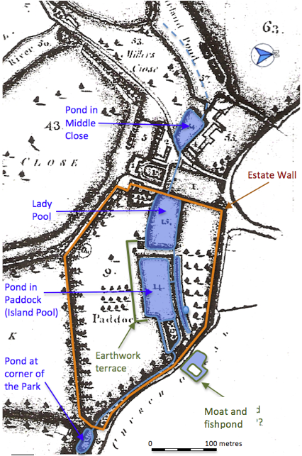
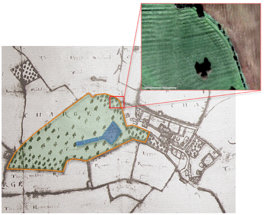
Fig. 14 Fishponds south of church, 1772 map
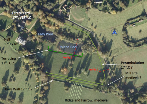
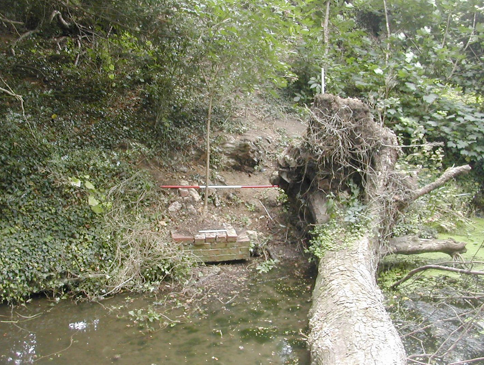
Four ponds are recorded on an important estate map of 1772 (Linnell) running in an arc to the south of the church. From east to west these were labeled as the Pond at the Corner of the Park, the Pond in the Paddock (now the Island Pool), the Lady Pool and the Pond in Middle Close (Fig. 14). Upcast on the banks indicate that the first of these has recently been cleared by mechanical excavator potentially changing its size and shape. Today it is roughly rectangular and is fed by a culvert under the road from an adjacent pool which is not on the 1772 map and signals an attempt to clear marshy ground around a natural spring. Earthworks suggest that this pool originally supplied water to a small mill to the west.
It is possible that a series of fishponds continued down the valley to the west, however, it seems likely, given their central location within the later park, that each of these was heavily re-modeled in the post-medieval period. The Island Pool in particular may have started as a smaller medieval fishpond, been enlarged in the seventeenth century to create a stew pond and then further improved in the eighteenth century by the addition of a narrow curving water course that defined an island at its east end.
The Island Pool’s southern limit is marked by a terrace nearly 2 metres high, although there has clearly been silting along this side reducing the pool’s overall width by around 4 metres. To the north is a further long thin pond running parallel to it and separated from it by a low bank (Fig. 15). The bank is pierced at a single point to unite the pools. Some decayed brickwork at the northern end of this channel indicates the presence of a sluice gate. The function of the narrow pool is again problematic. The most likely purpose of the complex was to manage the creation and harvesting of fish stocks. In medieval terms the large pool would be for breeding, the vivarium, and the linear pool would be for holding fish, the servatorium, before removing the available catch by sweeping a net along its length (Currie 1990:22).
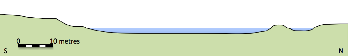
Fig. 15 The Island Pool, profile 1.
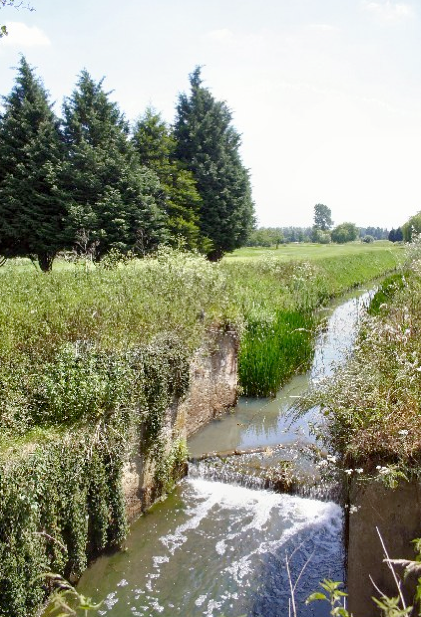
The water is held in place by a broad earth dam (Fig. 16) and is drained from the western end of the linear pond through a brick lined culvert into the Lady Pool. The slightly smaller Lady Pool is rectangular and in turn is drained through a sluice gate which leads into a culvert running underneath the lawn, the estate yard and ultimately into Sourland Pond.
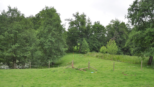
Fig. 16 Dam between Island Pool and Lady Pool, from south (Photo VW).
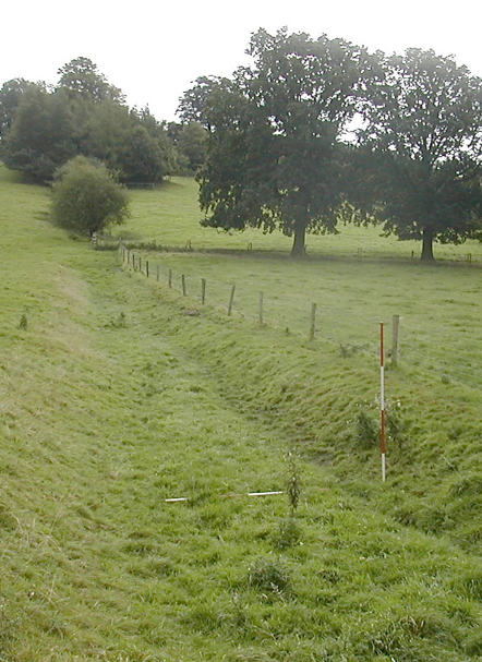
In 1772 there was another body of water, the Pool in Middle Close. This was filled in possibly during early nineteenth-century work on the estate, however, a low retaining dam survives which defined its eastern end (Fig. 17).
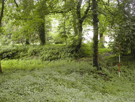
Fig. 17 Dam for Pool in Middle Close, from north.
A further focus of interest lies to the north of the village in a small valley running east-west (Fig. 8). The field here, named in the 1772 survey as Great Pool Close, is today laid down to pasture. However, there are some interesting indications of the presence of a ‘great pool’. Towards the north-west side of the field and along its north-east and south-east margins is a well marked terrace around 1.5 metres high which roughly follows the 140 metre contour. The natural lie of the land causes a considerable narrowing of the valley towards the southern corner of the field where there is a low earth bank, now broken through, and an adjacent level platform which could be the site of a building (Fig. 18). The limit of the pool is also demonstrated by the termination of a well preserved set of ridge and furrow (Fig. 19), evidence for the pool being medieval in origin. Other potential early pool sites include Little Pool Close, marked on the 1772 map a couple of fields over to the north. A small rectangular pond can be seen here, although it is much eroded by livestock drinking from it. Ordnance Survey maps up to 1972 show the triangular Hay Pool at the north end of the village (Fig. 10) but this has since been built over.
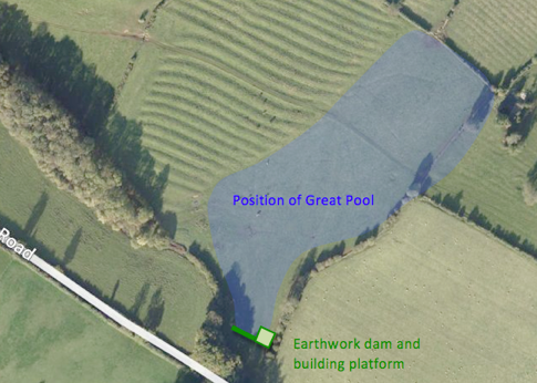
Fig. 18 Great Pool Close, from south.
Fig. 19 Great Pool Close, aerial view.
The Mill Sites
Although none were recorded at Domesday one might expect water mills to feature in the village economy. Three potential sites have been identified as pre-dating the emparkment, none of them particularly large. It is unlikely that they would have been operating at the same time with shifting locations reflecting changes in technology or economy.
The first potential site is in the Paddock (Fig. 20). An earthwork consisting of two parallel channels emerges from the pool further east. On the south side of these channels is an obvious leveled terrace which may be the site of a mill building (Fig 21). One could envisage a wheel across the southern most channel with the northern one acting as a bypass. Any original mechanisms for controlling the water would have been swept away when the estate wall was built, possibly in the 1620s and by a later farm track. There are some traces of stone work, particularly on the bank dividing the channels.
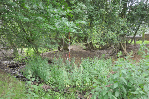
Fig. 20 Mill site in the Paddock, bypass channel left, building platform right, from west (Photo VW).
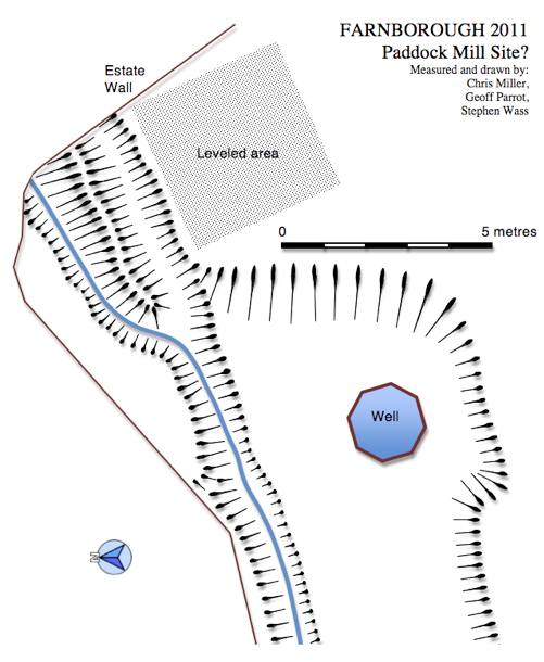
Fig. 21 Mill site in the Paddock, plan.
The second site is at the southern end of the Great Pool (Figs. 18 and 19). This would have been the largest body of water in the medieval landscape and the combination of dam with adjoining building platform must be significant.
The final area of interest lies to the west of the hall. For some time the Holbech family maintained that the eighteenth-century cascade was built on the site of a mill (Meir 2006: 91). The adjacent meadow is named Millers Close on the 1772 map but when a detailed survey of the cascade was undertaken there was no evidence for the reuse of an earlier structure (Wass 2011a). What was clear, following a closer examination of the map (Fig. 22), was that there was a small ‘L’ shaped building to the north. Given its position, immediately next to the outflow from the eighteenth-century Oval Pond, it is possible that this was the earlier mill site. Examination of the ground today reveals the scattered stone foundations of a small building (Fig. 23).
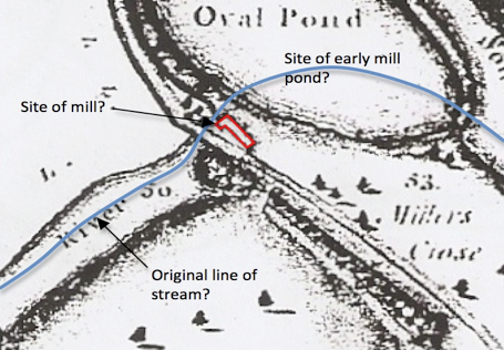
Fig. 22 Area around Cascade, 1772 estate map.
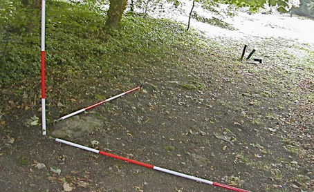
Fig. 23 Stone foundations of ‘L’ shaped building, from west.
In
considering these potential mill sites it should be noted that it would
be possible for the entire mill to have been of timber frame
construction (Astill 1993), as we can illustrate with ethnographic
parallels today (Fig. 24). The use of water power in the middle
ages, whilst essential to the local economy, may have been based on
quite ephemeral structures.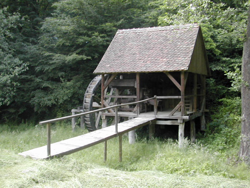
Fig. 24 Water mill, early twentieth century, Astra Museum, Sibiu, Romania.
Discussion
The early use of water at Farnborough is reflected in fishponds and mill ponds. The community would depend on these for food (Fig. 25) and power. We also get hints of other functions: defensive as in the case of the moat and spiritual as evidenced by St. Botolph’s Well. The essential nature of water is undeniable, what is harder to grasp is what this resource actually meant to the community. The conventional picture of resource use mediated by the manorial authorities may fall short with respect to the interest that the peasantry had as stakeholders. In terms of capital investment the chief land holders would pay for the construction of mills and ponds to generate income, but the position of those who worked the land was perhaps, as Dyer (2009: 183) suggests, more nuanced: ‘The peasant economy contains paradoxes. Peasants produced for the market, yet practiced self-sufficiency; they made technical innovations, while continuing with many traditional practices; they were consumers, but on a modest scale… the final paradox of the peasantry concerns the collective nature of their agriculture, while they retained a high degree of individual autonomy’. This suggests a greater degree of independence in thought and deed than is generally recognised and opens up the possibility that there was a sense of shared ownership of water resources even though technically they remained in the possession of the local lord.
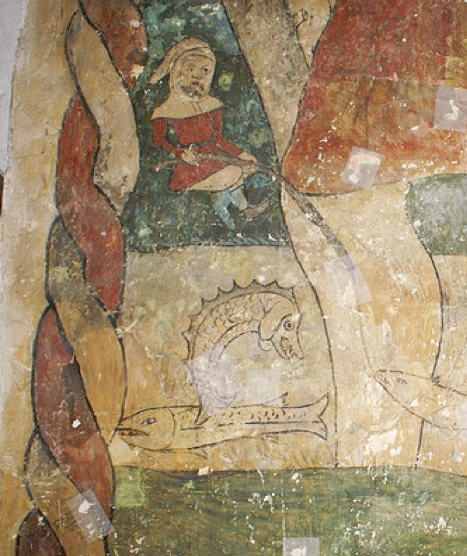
Fig. 25 Angling, 14th century wall painting, Horley, Oxfordshire.
The manor was securely in the grip of the Ralegh family by the mid-fifteenth century. In the early-seventeenth century Sir George Ralegh enclosed 200 acres of land by re-grouping estates through mutual consent (Salzman 1949: 84). This early instance of enclosure may have been the occasion for the demolition of some buildings in Church Oakal as it was noted that this resulted in the loss of 13 houses. At the same time a specific area was set aside for a park in what was later called The Paddock (Fig. 30).
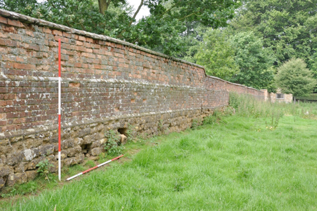
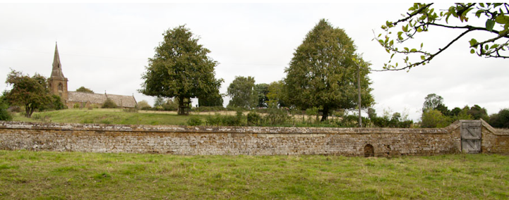
The Paddock is the only large enclosure which is completely walled. Where the wall runs alongside the lane from Banbury it is of stone with an elaborate moulded capping (Fig. 33). Although this has been largely rebuilt in modern times the point remains that it is a high status construction which presents an impressive face to the public highway. The lane, crossing the valley on an embankment up to 2 metres high that is retained by the estate wall, may have also been constructed in the early-seventeenth century as it cuts across the medieval earthworks. The wall which forms the southern margin of the Paddock is brick over lower courses of stone (Fig. 26) and can be seen on aerial photographs cutting across ridge and furrow (Fig. 30). This is another well built structure with two offsets defined by courses of moulded brickwork.
Dating bricks from appearance alone is difficult (Bailiff 2007: 828). However, the small size, colour range and degree of erosion certainly appears seventeenth century when compared with better dated examples such as those that may be seen at Chesterton (1630s) and Packwood (1650s) both in Warwickshire.
The ponds have already been discussed in detail (pages 11 to 13) and although possibly medieval in origin they seem to have been remodeled to become the focus for the Jacobean Park.
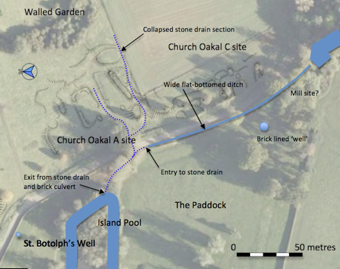
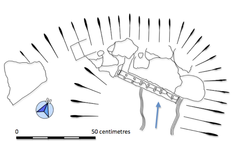
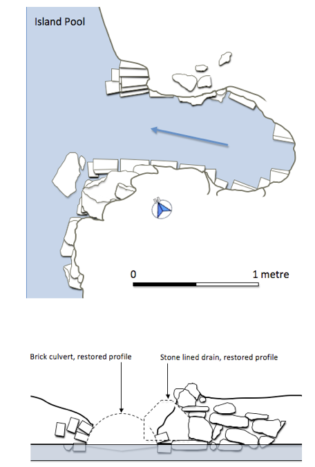
The hypothesis that this small park was created in the early-seventeenth century and supplanted medieval arrangements gains further support by considering the drainage patterns. A series of stone lined drains take water out of the site of the former moat and attached fishpond and empty into the top end of the Island Pool (Fig. 27). These drains are characterised by the rough quality of the work but are fully lined in stone and at one point an entry is protected by iron bars (Fig. 28). At the outlet point into the pool the stone drain is obviously cut by the insertion of a later eighteenth-century brick lined culvert (Fig. 29). The culvert is set at a lower level indicating that further efforts were made to improve the drainage of the land to the east and suggesting an earlier date for the stone drain.
The final features which, if not precisely dating the creation of the park, signal its special status, are the earthworks which give additional definition to the perimeter on all sides, except the west, where the landscape has been altered by developments in the mid-eighteenth century. The presence of viewing terraces over-looking Jacobean gardens is well documented (Currie 2005:14). The terraces and shallow ditches here define a circuit of the park that could have been walked, ridden or driven, in short a perambulation. This can be paralleled at nearby Wormleighton, Warwickshire, where medieval fishponds had, by 1632, been adapted to form the centre piece of a small wooded park (Mowl and James 2011: 39) whose margins were similarly defined by an earthwork which shadowed the boundary (Fig. 32). The perimeter earthworks at Farnborough (Fig. 30 and 31) may reflect the later eighteenth-century practice of defining the margins of the fields with double rows of trees as depicted on the estate map (Fig. 14), however, whilst this was widespread throughout the park, nowhere else shows the terracing seen in the Paddock.
The hall’s earliest architectural features are on the west front which probably dates from around 1700. Some thick internal walls indicate the possibility of an earlier house encased in the eighteenth-century construction (Haworth 1999: 16). A large pile of stonework behind the estate yard derives from the demolition of the service wing in the 1930s (Haworth 1999: 19). This shows evidence for a stone building of massive construction with stone mullions that would not be out of place on a major building of the early seventeenth century. Enclosures of the early 1600s could have gone hand in hand with the removal of the hall from its previous moated site to the rather drier location to the west, with improved prospects in both senses of the word.
Discussion
This analysis of the creation of the seventeenth-century park is largely based on conjecture, drawing together the facts about enclosure and the topographical evidence. However, if we accept this development as likely a number of consequences followed on for the locals. The turmoil occasioned by early enclosure is well documented and commented on. In many cases the attractions of sheep farming lead the drive to early enclosure. At Wormleighton the Spencer family had five shepherds looking after 10,000 sheep (Stocker 2006:82) partly on land formerly part of the village. Although peasant uprisings were not common, 45 outbreaks of rioting were recorded in England between 1585 and 1660 (Walter and Wrightson 1976: 26). There were a series of anti-enclosure riots known as the Midland Rising of 1607 which ended in a pitched battle at Newton in Rockingham Forest. During the course of this around 1,000 Levellers were driven off and some 50 dispatched on the spot. These instances of ‘rebellions of the belly’ (Hindle 2003: 137) occasionally resulted in direct attacks on the grand houses.
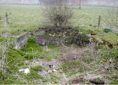
We have no indication of any unrest at Farnborough, but it is difficult to imagine that radical changes went unremarked. The customary patterns of rights, duties and obligations linked to usage of mills and fishponds must have been subject to change following the creation of the park. Of further significance was the exclusion of the community from access to St. Botolph’s Well (Fig. 33). The arrangement of church, holy well and connecting thoroughfare was probably an ancient one which reflected the communal use of this spring for practical and spiritual purposes. What is striking today about the spatial relationship is that the seventeenth-century park wall cuts across the bottom of the former route and effectively restricts access to the well as it is now on private property.
A door in the wall, which by analogy to other local properties, appears to be eighteenth century (Wood-Jones 1963), was provided to allow some access. This door could only be opened from the park side. Even allowing for the fact that the Reformation brought about a divorce between the established church and the idolatrous practice of visiting a holy well one must assume that on some level of superstition the well still occupied an important part in the community’s consciousness. What was communal has become private.
The Holbech family belonged to that category of English landowners often described as country gentry, members of a broad spread of second ranking elite, below the comparatively small number of peers but above the numerous ranks of those engaged in trade (Cannon 1987:10). The Holbechs would find themselves somewhere within the spectrum described by Corfield (1996: 4) ‘At the upper end of the scale, the gentry included the younger branches of the nobility… at the lower end of the scale, the status of the lesser gentlemen tailed away into the ranks of the substantial freeholders or yeomanry’.
There are some problems in writing an historical outline of the Holbechs of Farnborough. All four major published accounts are essentially the same (Nares 1954, Haworth 1999. Meir 2006 and Ince 2011) and refer back ultimately to ‘family tradition’. Holdings in the Warwickshire County Record Office include several boxes of papers including: surveys and plans (WCROL1); estate and household accounts for 1813-94 and a scrapbook containing miscellaneous correspondence (WCROCR 656); and estate and household accounts for the years 1771-1782, 1791-1796,1810-1812 (WCROCR 1799). Valuable as these are for understanding subsequent management of the estate, they offer no coverage of the crucial years when the park was under development.
The family originated in Lincolnshire but moved to Fillongley, Warwickshire in the fifteenth century and rose to prominence within the county over the next two hundred years. Ambrose Holbech (1596 – 1662) settled in Mollington, a parish adjacent to Farnborough, in 1629. His son, also named Ambrose, became a lawyer who, according to his monument in Mollington Church was, ’very eminent in ye Law… which he practiced with great integrity’. He clearly had some influential contacts, marrying his daughter Sarah to Sir Thomas Powys who became solicitor-general in 1686. In 1684 Ambrose purchased the estate at Farnborough from the executors of the Ralegh family. Nares (1954) notes that the estate was ’much encumbered’ and that only £2,260 out of the total purchase price of £8,700 was paid, the remainder having been advanced by Ambrose as a mortgage on the property. Work on the house and grounds was begun by Ambrose’s son William who in 1692 married an heiress, Elizabeth Alington, but it was their son William, who succeeded his father in 1717, who was responsible for the main changes (Ince 2011: 85 to 88).
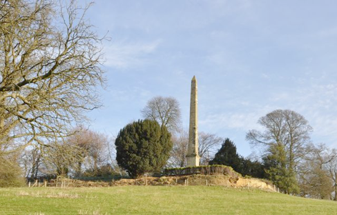
The family tell the story that William was ‘disappointed in love’ and around 1724 he departed for Italy, where he lived for over a decade. Upon his return he brought with him paintings and classical sculptures which established his reputation as a connoisseur. Early in the 1740s work began on remodeling the house and park with a strong emphasis on the classical. In the house paintings by Canaletto and Panini were hung amidst elaborate Rococo plasterwork (Fig. 35). About the park no less than four buildings were erected in the classical style. These were associated with the construction of a huge terraced walk running south from the hall (Fig. 39) and were: the Game Larder (Fig. 92), the Ionic Temple (Fig. 38), the Oval Temple (Fig. 40) and the Pentagonal Temple, now lost beneath a nineteenth-century cistern. In addition an obelisk (Fig. 34) was stationed at the end of the terrace walk completed in 1751. William never married and continued to supervise his estate until his death in 1771.
His nephew, also named William, took over the house and garden and one of his first acts was to commission a detailed survey of the property by Edward Linnell ( Linnell 1772). This consists of a series of detailed maps, often of individual fields and is of enormous value in understanding the work carried out earlier in the century. William died in 1812 and the property was inherited by another William ( 1774 – 1856). The new incumbent was responsible for developing the estate in association with the architect Henry Hakewill (English Heritage 2011). A further lengthy period ensued until the house and park passed to William’s third son Charles (1816 – 1901) in 1856. Charles took holy orders, became archdeacon of Coventry and, as well as spending large amounts of money on restoring the church, also built a new road that linked the village with Avon Dassett to the north-west. In 1901 the inheritance passed to his grandson William (1882 – 1914) who died during the First World war whilst serving with the Scots Guards. His brother Ronald (1887 – 1956) took the property on and it should have passed to his son Edward (1917 – 1945) but he died in an accident on VJ day. Subsequently a settlement was made and Geoffrey (1919 - ), Edward’s brother, inherited the estate. Much of it was sold off in 1948 following damage by serious gales in the previous year and in 1960 the remaining property, including several residences in the village, passed to the National Trust in lieu of death duties.
Discussion
A number of key questions remain unanswered by the historic record, most notably queries linked to the work done by the Holbechs towards the end of the seventeenth and into the eighteenth century. First amongst these is how was it planned and what did it cost? We also need to understand how the work was carried out. Further questions relate to how the park was used and ultimately, what was its purpose? In the absence of relevant documentation we will need to turn to the archaeology of the park for partial answers to some of the questions, as they relate to the use and management of water resources.
Studies of period gardens have mainly taken an art-historical approach and our understanding of the technology employed in these landscapes remains limited (Roberts 2001: 12). In order to examine the construction of the eighteenth-century water features we will make use of contemporary manuals and the limited number of archaeological investigations on related structures.
Ponds and Dams
The garden designer and engineer Stephen Switzer (1734:128) felt it was easy: ‘With us… every ploughman and shepherd is able to make good reservoirs or ponds for holding of water’ and gave clear directions as to proportions: ‘three foot horizontal to one foot perpendicular’ and materials: ‘large spits of clay together just as they are dug out of the pit, only picking out the large stones, or any veins of sand you can find therein… then you are to throw some slaked lime over it’ (Switzer 1734:131). Roger North (1714: 5), ‘a person of honour’, writing two decades earlier gave similar advice as to materials and in particular the importance of, ‘good ramming, from a foot or so below the surface of the ground to such height as you propose the water shall stand’. His sizing for a middling pond indicates that for a dam 14 foot high at the centre one must, ’make your bank at the foot at least 50 foot wide, straightening by equal degrees on either side bring it up to 16 at the top’. North (1714: 15) was also very specific about the demands made on labour, ‘take the assistance of your neighbours and provide yourself with six tumbrels, four good horses and two stout labourers, besides a driver to each pair of tumbrels. I call them pairs because they work alternatively with the same horses so that one is filling, while the other is moving and your labourers as well as horses are always at work’. North (1714: 17) later recommends upping the labour force to twelve which should be adequate so that by, ‘observing these directions you may make two ponds in one month and not expend in money above 80 pounds although you pay for every hours work of man and horse’.
It is interesting to compare this forecast with other work that has been done on sites such as the experimental earthwork on Overton Down where labourers, using basic technology on hard chalk, could shift around 0.15 cubic metres per person per hour (Jewell 1963: 51). More material than this could be dug, but that demanded two other labourers moving and piling the spoil. A more recent set of figures comes from advice issued by the University of Sterling Institute of Aquaculture (2012) who, in giving guidance in reservoir construction for the tropics, suggest that for digging and moving earth by hand one cubic metre a day is reasonable whilst those spreading and compacting could handle two cubic metres. We can appreciate the scale of the work at Farnborough if we consider the dam of the Oval Pond. This amounts to around 10, 500 cubic metres of earth and would give North’s twelve stout labourers over 875 cubic metres each to shift, around three years’ work. If they wanted to complete the job in a summer season between planting and harvest, say 100 days, they would need to employ roughly 100 workers a day. Given that the entire male population of Farnborough in 1821 was 179 (Warwick CRO DR299/16) it is easy to see why North’s advice to call on neighbours for assistance was so apposite. Not all members of the gentry would take on such a project on a ‘do-it-yourself’ basis and it is possible that a professional engineer was employed at Farnborough such as John Grundy of Spalding (1719 to 1783) whose experience came from work on drainage and flood defence in East Anglia.
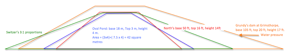
He was employed at Grimsthorpe Hall, Lincolnshire from 1745 to create the Great Water, a project for which his notebooks survive (Roberts 2001). Grundy’s work was generally considered to be of high quality and more technically accomplished than that of his competitors
(Roberts 2001: 18) and his cross valley dam at Grimsthorpe, whilst a little higher, is considerably wider than those at Farnborough (Fig. 73). Even so he was compelled to return in 1758 and 1774 to make repairs. His use of additional timber piling and a further clay lining (Roberts 2001: 24) recalls the situation at Noke, Herefordshire where the excavation of an early eighteenth-century dam revealed wooden stakes set in clay (Currie and Rushton 2001: 230). The dams at Farnborough are largely grassed over and there have been no opportunities to examine any internal structure.
Drains
Contemporary writers stressed the importance of a dependable supply of water and enormous pains were taken to ensure this, including the provision of subsidiary reservoirs around springs and on occasions pumps operated by animals or waterwheels (Roberts 2001: 22). It seems that at Farnborough the existing springs and streams were adequate for the task and, together with the drainage of the surrounding meadows, provided sufficient water. The complex pattern of drainage around the former manor site has already been noted (pages 20 to 21). Recent excavations have shown that prior to the nineteenth century a large quantity of ironstone quarrying debris was dumped in the moat to partially fill it and no doubt improve drainage (Wass 2012a). Brick lined culverts have been recorded emptying into the Island Pool and running below the dam of the Oval Pond. In addition a curious set of broad shallow drainage ditches have been noted, following the field boundaries on the estate map and running straight down the hill below the terrace (Fig. 74).
Sluices
The most refined technical accomplishments are the sluices along the Serpentine River. Currie (1990: 35) notes that, ‘in all the treatises examined there is very little recorded about sluices’, perhaps because they were regarded as the province of specialized craftsmen. Usually the term sluice describes an arrangement for draining a pond through a pipe or culvert, often of wood, that passed below or round the dam. Control was usually by wooden paddle or bung (Roberts 2001:22). The sluices at Farnborough are much more reminiscent of staunch or flash locks, features associated with early canal and river navigation. These operated on the principle of a pair of mitre gates which retained the water at a suitable level for navigation. Approaching boats were held back while a small sluice was opened to drop the water level a little and then the gates were opened to allow the boats to slip through. Such locks (Fig. 75) were used from the earliest times and were still reasonably common in England in the first half of the eighteenth century until they were replaced with the more familiar pound locks (Hadfield 1968: 19). Was the Serpentine River navigable? A similar visual effect could have been achieved by more conventional earth dams, so the sluices must have been installed with some functionality in mind, however, there is no evidence that the stream beyond was ever adapted for boats.
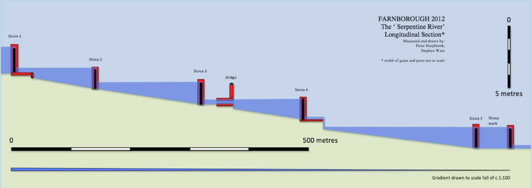
Projecting the water levels back from the presumed height of the gates gives an indication of the relative water heights and demonstrates that the cascade below sluice 4 would have been visible even when sluice 5 was closed (Fig. 76). Could Holbech have employed contractors whose experience on early canals led them to build the only way they knew, or were the sluices designed simply to demonstrate the technology? Would the arrangement have helped if there was ever a need to drain the water-course in a hurry? The whole question of the use of sluices on the Serpentine River remains open, but the conjecture is that they had some purpose other than the ornamental.
Finance
North promised that one could deliver a lake of between three and four acres for eighty pounds. Given that most of the raw materials would have been available on the estate the main cost would have been for labour at as little as a shilling a day (Porter 1991: vii). If a specialist supervisor had been appointed on the same basis that Grundy worked he would have charged one shilling for each pound of the project’s cost (5%). Money would need to be set aside for both carpenters and stone masons to work on sluices and cascades. These higher paid artisans may also have been available as employees of the estate, but would have commanded higher wages than the labourers, as much as five shillings a day. Taking all this into account we might expect the work on the Oval Pond to have cost in the region of £600. A further attempt at costing can be made on the basis of sums paid out during the construction of the Wiltshire and Berkshire Canal in 1797, where 31/2 d per cubic metre was paid for digging and 11/2 d for carting (Lawton 2006: 300). On this basis the earthworks alone could have cost around £300. Similar calculations for the other water features suggest an overall bill for Farnborough between £2,500 and £3,000. This compares with an estimate for £1,250 2s 1d from Grundy for a major expansion to the Great Water at Grimthorpe (Roberts 2001: 28)
There is one near contemporary account of the workers’ efforts, penned by a local curate, Richard Jago, who was a friend of Miller’s.
Alas we must in all probability ascribe the work force of five hundred and their merry countenances to poetic licence and there is no mention of their wages.
Williamson (1999: 252) suggests that, ‘Once we have reconstructed the layout and appearance of early landscapes we must… try to recreate the ways in which they would have been perceived and experienced from various spatial standpoints by the different social actors moving within (or excluded from) them’. This is not the place to enumerate every conceivable way in which people and water could have interacted but rather to focus on those aspects which have left significant remnants in the landscape. No doubt occupants of the hall made copious use of water for drinking, cooking and washing, however, as the service block which contained a dairy, brewhouse and kitchen was demolished in the 1930s there are few traces. It is worth noting the presence of an icehouse to the west of the hall (figs. 42 and 77) which made use of the seasonal freezing of pools (Buxbaum 2008). Workers would have chopped out blocks of ice in the winter to provide ice for the kitchens in the summer.
In order to populate the eighteenth-century landscape we will need to turn to other contemporary documents including paintings. Being aware of the dangers of projection and the assumptions one makes about the ‘familiarity of the past’ (Tarlow 2004) , one can attempt to gain insights by appealing to common human impulses which are shared today by workers in the park and visitors to it. The ponds and waterways were a place of work to those who laboured on the estate and of leisure for the Holbechs and their guests. It is interesting that it remains the case that most accounts still present an upstairs rather than a downstairs perspective of the country estate.
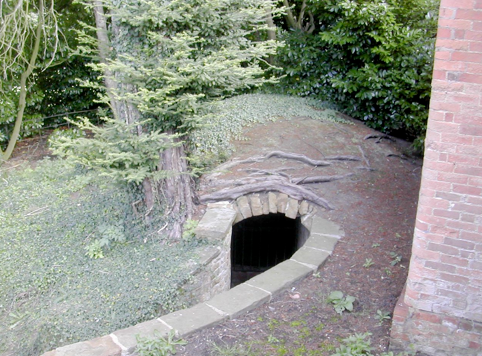
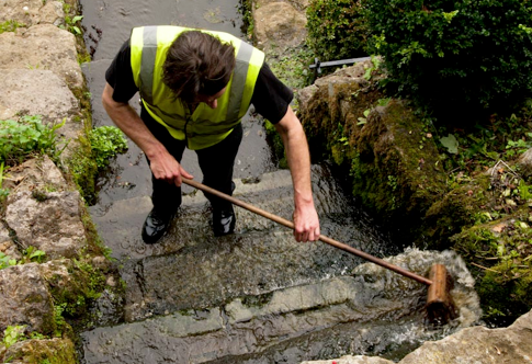
Fig. 77 Icehouse entrance, from south-west. Fig. 78 Scrubbing algae off the Cascade (Photo CM).
Work
In working with water, the local labourers would have had a role both in construction and maintenance. Tasks, which are shared by the modern work force, included periodic dredging of pools as they silted up, repairs to banks damaged by livestock and unblocking and repairing sluices. Observations on the cascade have shown that in summer the stonework becomes covered with unsightly brown algae which needs to be removed by hard scrubbing every couple of weeks (Fig. 78).
It seems likely that the pools were managed for fish into the eighteenth century, a complex business involving transferring stocks from pool to pool, feeding, the periodic emptying of pools for cleaning and, of course, harvesting and preparing the fish for the table (North 1714: Chapters XI to XVIII). Even with every modern aid working around water is a cold and dirty business, how much more so in the eighteenth century. We have no documentation relating to these processes at Farnborough, as is the case generally, the voice of the eighteenth-century labourer remains silent. The fact that it is easier to say many more interesting things about the recreational uses of water is perhaps a simple reflection of the cultural hegemony enjoyed by the social elite.
Leisure
North (1714:73) is particularly strong on the recreational benefits that accrue to a gentleman’s family as a result of embracing water, ‘Young people love angling extremely; then there is a boat, which gives pleasure enough in summer, frequent fishing with nets, the very making of nets, seeing the waters, much discourse of them, and the fish, especially upon your great sweeps, and the strange surprises that will happen in numbers and bigness, with many other incident entertainments, are the result of waters, and direct the minds of a numerous family to terminate in something not inconvenient, and it maybe divert them from worse’. The view by Rysbrack (Fig. 72) also neatly encapsulates the recreational opportunities afforded by water. We see a couple promenading by the water, gentlemen angling from a boat and a flight of ducks available for wild-fowling, a pattern repeated in many similar genre paintings from the eighteenth century.
Walking.
Contemporary documents such as Miller’s own diary entry for July 21st. 1750 emphasise the importance of walking within the context of living well, ‘Lord North and Miss Legge breakfasted at castle. Went with Lord Cobham etc. to Mr. Holbech and to Dassett. Mr. Holbech dined with us. Camera Obscura. Walked with Lord Cobham, Holbech and Miss Banks round Wood Close, fountain etc. Supped at castle with Lord North etc. and Holbech. Fine evening. Music. Lord Cobham’s venison’ (Hawkes 2005: 150). The presence of water would enhance the experience of walking to all the senses, ‘when the shadows grow faint as they lengthen: when a little rustling of birds in the spray, the leaping of the fish, and the fragrancy of the woodbine, denote the approach of evening’(Whately 1770: 86). These experiences were not only confined to the owner and friends. There were opportunities for members of the public, albeit of the better sort, to make visits, often on carefully designed designated walks around an estate (Symes and Haynes 2010: 22). Although we have no indication that this happened as a matter of course at Farnborough, it is clear that other members of the gentry were made welcome and given the chance to tour the gardens (Meir 2006: 87).
Boating.
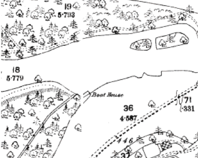
We have no evidence of boating in the eighteenth century at Farnborough. Although a boathouse is shown on the 1885 OS map on Sourland Pond (Fig. 79) it does not appear on the 1772 map, however, it is hard to believe that boats were not present here. Miller had designed a boathouse (Fig. 80) for Enville in Staffordshire (Meir 2006: 151) and would have been well acquainted with the extensive use of boats on the lakes at Stowe, Buckinghamshire (Felus 2006: 26). Lady Newdigate who visited Farnborough in 1747 might have expected to see boats. She wrote in her Journal of another location, 'in a small boat we rowed to the Severn and then in a very pretty vessel built by Mr. Cambridge, the Cabin lined with Japan and Indian paintings we sailed for several hours, the view all the way very pleasant' (WCRO CR1841/7: 53).
Sourland Pond seems an ideal venue for boating as its pronounced curve around Stanborough Hill would have given a feel for a great journey in a small space. Felus (2006: 30) also mentions the naumachia or mock naval battle, inspired by classical precedents and indulged in by the Byrons at Newstead, Nottinghamshire and the Dashwoods at West Wycombe, Buckinghamshire. Is it too fanciful to note that the Oval Pond shares very closely in the proportions and size of the floodable area of the Colosseum in Rome? This is not to say that William Holbech filled it with battling galleys but perhaps there was an echo of this famous monument somewhere in the back of his mind.
Angling.
The layout of the pools at Farnborough was well suited to the maintenance of fish stocks on a large scale and whilst fish could be caught by netting they would also offer the opportunity for the pastime of angling. Anglers appear in many eighteenth-century prints and paintings and a large number of books on the subject were published during the period (Rodd 1846: 84) attesting to its popularity as a sport for gentlemen and indeed ladies. Fishing pavilions known from Enville, Staffordshire ( Fig. 80) and Kedleston, Derbyshire reinforce this picture, but again, save for the existence of the ponds, we have no direct evidence for angling at Farnborough.
Wild-Fowling
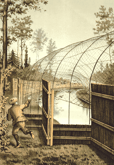
Another sport which gained popularity through the eighteenth century as firearms became more reliable and readily available was the hunting of wild fowl. It has been suggested that the island at the eastern end of the Island Pool with its narrow looping channel could have served as a duck decoy. This is unlikely as the normal form was to have lengths of water of diminishing width, opening off from a central pool (Heaton 2001). These were netted over and the birds lured or driven in to them (Fig. 81). It is more reasonable to assume that the island was created as a refuge for wild fowl, where they could roost and nest in safety from predators. The presence of the game Larder shows how important hunting was on the estate (Fig. 92).
Swimming
Of all the activities noted so far, swimming seems to be the one least likely to leave archaeological traces. It is hard to see today’s muddy, overgrown stretches of water, choked with fallen trees, as anything but a health hazard (Fig. 82) , however, when newly built with firm banks and pebble bottoms one could envisage features such as the Oval Pond or the Canal being appropriate venues for swimming. One possible indication that we have of interest in this activity is a document preserved in a Holbech family scrapbook from the mid-eighteenth century (WCRO CR656/36). Amongst newspaper cuttings for a variety of sports ranging from prize-fighting to horse-racing is an engraved handbill publicizing the opening of Peerless Pool in London in 1743. For a guinea a year gentlemen could enjoy all the benefits of swimming in a safe environment with ‘waiters’ on hand to teach swimming to novices. The accompanying illustration not only shows swimmers in action but also a couple of adjacent ponds for angling and two large prospect mounds joined by a terrace ‘planted with limes’. If nothing else it is an indication of the kinds of cultural influences that could have been operating on Holbech during the crucial decade in the park’s transformation.
Experiencing the Cascade
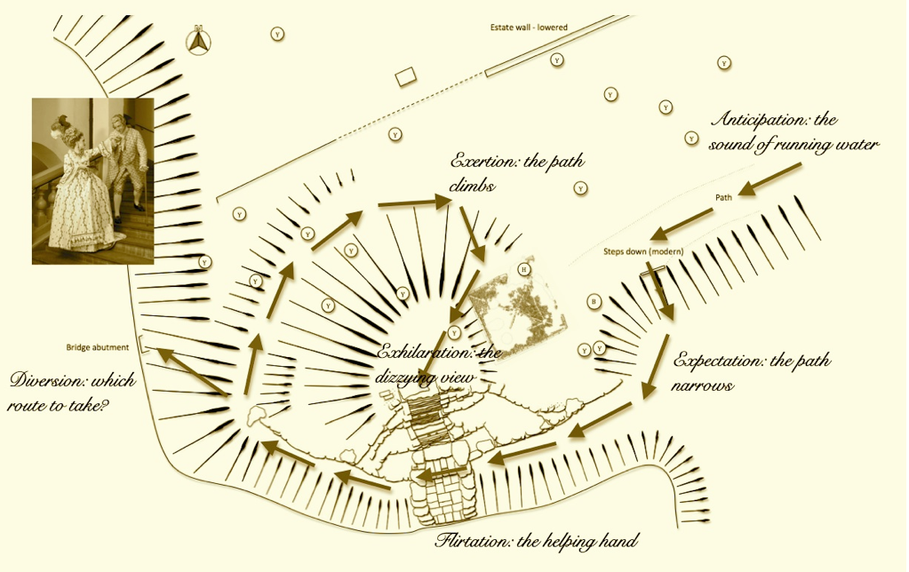
Our final imaginative leap is to attempt to draw on even less tangible elements of the past and recreate one potential way in which a water based construct could have been experienced in the eighteenth century. This idea was developed in an earlier piece (Wass 2011c) where we noted the lack of visibility on the approach to the Cascade implying an element of discovery and anticipation for the visitor. The structure of the Cascade (Fig. 50) seems to draw one into experiencing it in very particular ways which include walking across the flat slabs at the base of the flow (Fig. 83) and striking out along a spiral path to attain the summit with its view along the River (Fig 51).
This led to the creation of a slightly tongue-in-cheek visitor’s guide (Fig. 84). Other sites where, ‘garden features… were designed to trick, tease or thrill the visitor’ have been listed (Wass 2011c: 16), including the hidden fountains at Wilton House which were ‘… like a plash’d Fence, whereby sometimes faire ladies cannot fence the crossing, flashing and dashing their smooth soft and tender thighs and knees by a sudden inclosing them in it’ (Quoted in Strong 1997: 130). This kind of titillation may have been better suited to earlier centuries or warmer climes (Thacker 1970: 20), but we must allow for the possibility of an eighteenth-century sense of fun.
Discussion
One is very aware of the contrasts between the two different ways in which people experience water around the park. On the one hand the labourers responsible for its upkeep were likely to be task oriented and motivated by the simple mechanics of providing for themselves and their families. Their options were limited and their focus on getting the job done in the best way they knew. On the other hand there are the gentry who had so many more options to choose from. It was even possible to write poetry; in 1786 M. Dawes published an octavo volume entitled ‘Holbeach Fish-pond, a Poem’ (Rodd 1846: 84), unfortunately we have not been able to discover a copy.
It is important not to fall into a narrative which features, ‘contests between hapless peasants and villainous landlords’ (Tarlow 2007:10) and accept Williamson’s (1999: 253) point that, ‘eighteenth-century England was a complex society and not one composed of two confronting groups’, however, it is difficult to think about a feature like the Oval Pond without considering dichotomies. Walking out towards Meir’s (2006: 91) ‘bastion’ at the far end of the pond one would be confronted with an astonishing prospect. To the right the large elevated expanse of water, perhaps with pleasure craft upon it, to the left and decidedly below, a bleak landscape of labour consisting largely of the still open fields belonging to adjacent villages (Linnell 1772).
A structure such as the Oval Pond cannot be seen as anything other than domineering, it pushes out across flat fields and imposes leisure upon labour (Fig. 85). We do not know how this construction was viewed at the time, indeed all the labourers may have continued to be ‘jocund’, relieved to have a steady wage from employment on the estate. Even so there is no sense in which this was a community enterprise, rather it represents a transformation effected by two gentlemen with their own particular and peculiar interests. One cannot believe that such a transformation was met with equanimity by the rest of the population.
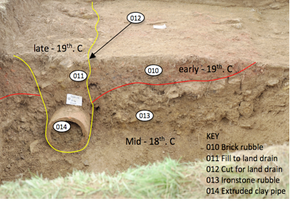
This narrative could be abandoned at the point where water usage is at its most extravagant but to do so would be like leaving off a biography without pondering the subject’s final years and possible extinction. By the early-nineteenth century the estate was in something of a decline. In 1810 a curious poem was posted anonymously to Charles Holbech, brother of the William who had inherited in 1771. The poem is entitled ‘The Lamentation of the Botanic Gardens at Farnborough’ (WCRO CR656/36) and appears to be a plea that the gardens be put in order so that, ‘no more shall urtica (nettle) eclipse the rose’, and ‘ no supple juncus (rush) with incessant bow, court the green mantle of the stagnant lake’. In 1812 another William took on the estate and by 1815 a further major programme of work was underway supervised by the architect Henry Hakewill (English Heritage 2011). The estate was put on a more productive footing and new buildings included cowsheds (Wass 2012d) and a large octagonal walled garden with a stone lined pool at its centre (Fig. 86). A graveled path led from the garden, through a short tunnel, to another path across the Paddock and up to the kitchens. The moat was further filled with brick rubble and, post-1850, large clay land drains were inserted (Wass 2012a), demonstrating the continuing importance of effective drainage (Fig 87).
In the early-nineteenth century a summerhouse (Fig. 88) was built on a terrace cut into the mound at the back of the Cascade and a wooden footbridge on brick piers (Fig. 89) thrown across the inlet to the River (Wass 2011b). This post-dates the building of a new road to Avon Dassett by Charles Holbech. The Oval Pond was drained between 1820 and 1880 and typically for the period was converted in a fox covert (Watkins, N. 2007).
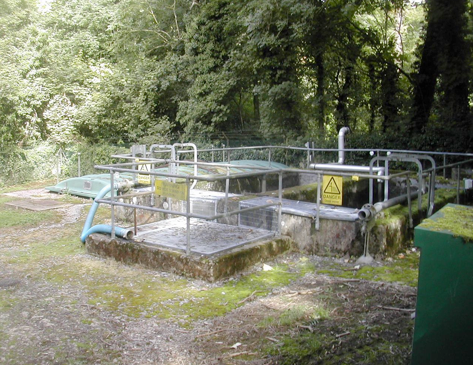
The kitchen garden was abandoned shortly after the First World War and was for a while worked as an independent market garden until it closed in the 1950s. The hall had had its own water supply from a borehole on the top of the hill to the south-east sunk in the first half of the twentieth century. The water was pumped up by a windmill and stored in a brick cistern before being piped to the hall. In 1957 mains water came to Farnborough and shortly afterwards a sewage works was built on the edge of the former Oval Pond (Fig. 90).
The Serpentine River was drained after the Second World War and in 1960 the National Trust took over guardianship of that portion of the park which had not been sold in 1948. Today the residents of the hall stock the pool with wild-fowl over winter for shooting and operate a small rowing boat on the River for retrieving downed birds. Sourland Pond is let out to the Banbury and District Angling Association and in the summer people come and picnic on the grass next to it. The grounds close to the hall are managed by a gardener and a part time assistant, whilst the remaining agricultural land is let out to a tenant farmer. The decades since the Second World War have not been kind to the monuments of Farnborough Park. Whilst those buildings with architectural pretensions have been well maintained, lesser buildings, including a small apple store and a bier shed and several agricultural buildings, have fallen into disrepair and in some cases, total collapse. Those structures which helped the water to do interesting things are in a particularly parlous state and again have either partially collapsed or are about to…
Following our chronological survey we will return to our central concern, the understanding of those elements within the eighteenth-century park linked to water and how they reflect ‘patterns of power and dominance’. We have touched on the answers to most of the questions posed in chapter 5 but two remain outstanding. The first of these is the question as to how it was all planned. The problems of assessing the contributions of a ‘gentleman architect’ have already been examined. Faced with these difficulties researchers Meir and Hawkes adopted the procedure whereby evidence of a visit to a site was fused with perceived stylistic traits to establish a corpus of work. It is no great criticism to point out the extremely speculative nature of this approach. Meir (2006: 217) especially, argues for the recognition of Miller’s fingerprints on a range of projects and suggests that, ‘The inventive use of water, and an ability to find successful technical solution to intractable drainage problems together form a major component of Miller’s “stylistic signature”’. She further cites an informal layout for lakes and a fondness for long thin waterways punctuated with sluices or cascades which occasionally are doubled up to run along side other existing water courses. The phrase used by Miller’s great-grandson to describe his involvement was ‘assisted by the advice of’ (Miller 1900: 61).
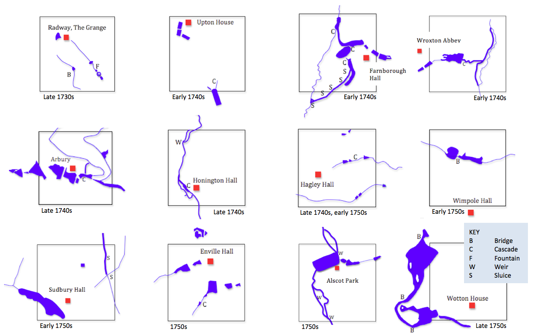
It is easy to see from Miller’s diaries how this assistance was rendered. Occasionally he would sit down and draw detailed plans (Hawkes 2005:161), but more often it was a walk in the park with Miller pointing out solutions to problems or opportunities for development, followed up perhaps with a letter ( Hawkes 2005: 164). This process of design through conversation throws open the possibility of dialogue between architect and patron and given the preponderance of classical detailing at Farnborough there is a strong case for William Holbech’s being the dominant partner. Miller did not have a good track record for classical buildings, indeed John Cornforth writing in Country Life dismissed Miller as someone who, ‘demonstrated no significant ability in working in the classical style at this date’ (Cornforth 1996 cited by Hawkes 2005). Apart from the five possible structures at Farnborough ( Figs. 34, 38, 39 and 92) Miller built only a handful of classical garden buildings during a thirty year career (Hawkes 2005: 391 to 408). Virtually all his other work was in the gothic style. The absence of gothic buildings at Farnborough indicates this strong lead from Holbech. If Holbech was giving instructions regarding the provision of classical buildings it is fair to assume that he may have made similar requests concerning unusual features like the amphitheatre and the Oval Pond. If we examine other water features attributed to Miller, the only thing at Farnborough typical of his work is the Serpentine River. In other respects both the scale and configuration of the works at Farnborough bear little resemblance to other projects (Fig. 93). The likelihood is that Miller was responding with advice and perhaps some technical expertise under the direction of a landowner who was trying to create a peculiarly classical landscape, which was not only reflected in the buildings, but also in the way in which earth and water were engineered. The source of inspiration was the vision, passion, perhaps even obsession, of the landowner.
The final question and perhaps the most challenging is what was the purpose of this large-scale landscape transformation? Individual landowners did not have to express or explain their reasons, even to themselves, so explanations can only ever be provisional, however, by looking at the wider context, we can venture some suggestions. There are four key concepts: the social politics of separation and unification, the demands of good taste, the power of imagination and the economics of the country estate.
Social Politics of Separation and Unification
Many commentators have stressed the ways in which eighteenth-century garden design was used in terms of legitimation, ‘a tool with which elites attempted to maintain power and authority over marginalized groups’ (Williamson 1999: 37). The estate is a means of control and domination by imposing a particular world view on a locality through landscaping whilst simultaneously restricting options for the rest of the community in terms of movement, access and labour. This is a powerful theme within Farnborough’s story. From the closure of the route to the holy well to the dominating effect on the landscape of the Oval Pond this seems to be about under-scoring inequalities of power. Williamson (1999: 37) did move away from this position taking the view that, ‘most acts of aesthetic landscaping…were primarily directed not towards "the poor" but to rival groups within the propertied’. In making this point he emphasized the closed nature of many parks of the period, however, Farnborough is a very open landscape, much of what is on offer is widely visible so perhaps Johnson’s (1996:145) more nuanced view that, ‘around the great house the gardens were planned as a mediation between the elite and the ordinary as well between Nature and Culture’ is more productive, reflecting interactions, both positive and negative, within the full spectrum of society. This is emphasized in Miller’s diaries (Hawkes 2005) where it is clear that he enters into relationships, within the context of the park, with all manner of men and women from lady to labourer. We can therefore take a more positive view of the park as a meeting place where certain boundaries can be crossed. It is equally obvious that within Miller’s social group, of which we must count William Holbech a member, as well as companionship there was also competition based on the notion of good taste.
The Demands of Good Taste
Opportunities for self expression were characterised by the fact that,
‘by the eighteenth century a patron could choose between one of a number of different architectural and landscape styles’ (Johnson 1996:152). If this was coupled with, ‘untrammeled or only very partially limited power over the exploitation and physical appearance of an extensive tract of countryside’ (Williamson 2007: 4) then the potential for making statements about one’s own aesthetic judgment was enormous. Holbech’s ten years in Italy, at a time when the Grand Tour was de rigueur, must have given him authority as an arbiter of classical taste amongst his social circle (Fig. 94). One can see his work at Farnborough as an exemplar as to what could be done but also perhaps an object lesson in the way in which tasteful could spill over into mannered if enthusiasm is given too free a rein. It was possible to be too imaginative and end up with that most despised quality, ‘the merely whimsical’ (Thoreau 1854: 19).
The Power of Imagination
In describing the park I have often found myself using the analogy, ‘it’s like an eighteenth-century theme park’. In developing a similar point about the gardens at Stourhead Harwood (2002: 50) writes of, ‘the recognition that what they were seeing were theatrically contrived settings, the juxtaposition of which suggested an organized collection of opportunities for imaginative play’. At the risk of falling into the trap of developing the ‘existential and isolated presentism of phenomenological perspectives’ (Hicks 2003: 321) one has to say that in experiencing the park today one senses a history of enjoyment. There has been a description, with some license, of the goings-on around the Cascade (Fig. 84) and there is a feeling that the disposition of the terrace buildings was to tantalize in the sense of, ‘I wonder what’s around the next corner’. From the erection of ‘toy’ forts (Felus 2006: 30) to the placement of hermit’s caves one was expected to use one’s imagination as a playful participant in the landscape (Symes and Haynes 2010: 33). Holbech’s scrapbook of newspaper cuttings (WCRO CR656/36) reveal him to be something of a sportsman, was he a joker too?
Economics of the country estate.
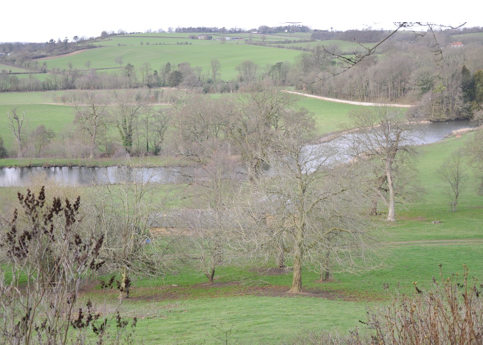
The concept of improvement is often linked to ideas of economic advancement, but Tarlow sees it as also demonstrating,’ the ownership of rational knowledge and taste, a general orientation towards the future and a selective rewriting of the historical and classical past’ (Tarlow 2007: 67). This combination of the productive with the decorative was praised by Switzer, ‘a whole estate will appear as one great garden, and the utile woven harmoniously with the dulci… I affirm that an even walk carried through a cornfield or pasture… is as pleasing as the most finished parterre’ (Switzer 1742: 8). Farnborough represents an ideal example of such a ferme ornée: the ponds are a source of fish as well as a venue for boating and the view towards the River takes in the pasture known as the Dairy Ground. A striking feature of the park is the way in which unproductive land is turned to recreational ends. Sourland Pond speaks for itself and it is noticeable how the Terrace occupies the steep, wind-swept brow of the hill leaving the summit and slopes for grazing. Ponds and pounds march along together.
The End.
The park’s purpose was intimately linked to the social fabric of the time and served many of same purposes as today’s gardens: supplementing the family diet, relaxation, exercise, entertaining and of course one-upmanship but, as with any archaeological site that exhibits a number of unique features, Farnborough Park remains both baffling and revealing. There are many unresolved questions about how the landscape was manipulated by Holbech and Miller but what is clear is that we have a classic case of the exploitation of a particular resource, water, in a way which demonstrates the acquisitive drive of the land-owning elite over several centuries. There is no access to St. Botolph’s Well or the adjacent pools. The River and Canal may be viewed from the terrace after paying an entry fee but the Serpentine River is becoming quietly lost amongst commercially farmed land to the south. Only Sourland Pond exists as a community resource with fishermen lining its banks and families from Banbury coming out to feed the ducks. (Fig. 1).
Aberg, F.A. (ed.) 1978. Medieval Moated Sites, York: Council for British Archaeology
Astill, G. G. 1993. A Medieval Industrial Complex and its Landscape: the metal working watermills and Workshops of Bordesley Abbey, York: Council for British Archaeology
Aston, M. 1985. Interpreting the Landscape, Landscape Archaeology in Local Studies, London: Batsford
Aston, M. (ed.) 1988. Mediaeval Fish, Fisheries and Fish-ponds in England, Oxford: British Archaeological Reports
Bailiff, I. K. 2007. Methodological Developments in the Luminescence Dating of Brick from English Late-Medieval and Post-Medieval Buildings, Archaeometry Volume 49, Issue 4, pages 827 to 851
Blair, J. 1994. Anglo-Saxon Oxfordshire, Stroud: Alan Sutton Publishing
Buxbaum, T. 2008. Icehouses, Oxford: Shire Publications
Cannon, J. 1987. Aristocratic Century, The peerage of eighteenth-century England, Cambridge: Cambridge University Press
Chanson, M. 2001. Historical Development of Stepped Cascades for the Dissipation of Hydraulic Energy, Transactions of the Newcomen Society, Volume 72, pages 295 to 318
Cherry. R. 2011. Notes of conversation with local retired builder, 15.3.11
Chisholm, M. 1979, Rural Settlement and Land Use, London: Hutchinson
Corfield, P. J. 1996. The Rivals: Landed and Other Gentlemen in Harte, N. B. and Quinault. R. (eds.), Land and Society in Britain, 1700-1914, Manchester: Manchester University Press
Currie, C. 1990. Fishponds as Garden Features, c. 1550-1750, Garden History, Volume 18, number 1, pages 22 to 46
Currie, C. 2003. Archaeological excavations at Upper Lodge, Bushy Park, London Borough of Richmond, 1997-99, Post-medieval Archaeology, Volume 37, Number 1, pages 3 to 45
Currie, C. 2005. Handbook of Garden Archaeology, York: Council for British Archaeology
Currie, C. and Rushton, N. 2001. The Historical Development of the Court of Noke Estate, Pembridge, with an Archaeological Assessment of Canal-like Water Features, Transactions of the Woolhope Naturalists Field Club, Volume 50, Number 2, pages 224 to 250
Duignan, W. H. 1912. Warwickshire Place Names, Oxford: Oxford University Press
English Heritage 2011. Farnborough Hall, Banbury, England, Record Id: 1304 Register of Parks and Gardens of Special Historic Interest, http://www.parksandgardens.ac.uk/component/option,com_parksandgardens/task,site/id,1304/tab,history/Itemid,305/
accessed 12.9.2011
Felus, K. 2006. Boats and Boating in the Designed Landscape, 1720-1820, Garden History, Volume 34, number 1, pages 22 to 46
Gearey, B. R., Hall, A. R., Bunting, M. J., Lillie, M. C., Kenward, H. and Carrott, J. 2005. Recent palaeoenvironmental evidence for the processing of hemp (Cannabis sativa L.) in eastern England during the medieval period, Medieval Archaeology, Volume 49, pages 317 to 322
Gosden, C. and Marshall, Y. 1999. The Cultural Biography of Objects, World Archaeology, Volume 31, Number 2, Pages 169 to 178
Harrower, M. J. 2009. Is the hydraulic hypothesis dead yet? Irrigation and social change in ancient Yemen, World Archaeology, Volume 41, Issue 1 , pages 58 to 72
Harwood, E. 2002. Rhetoric, Authenticity, and Reception: The Eighteenth-Century Landscape Garden, the Modern Theme Park, and Their Audiences, in Young, T. and Riley, R. (eds.) Theme Park Landscapes: Antecedents and Variations, Washington: Dumbarton Oaks Colloquium on the History of Landscape Architecture, volume 20
Hawkes, W. (ed.) 2005 . The Diaries of Sanderson Miller of Radway, Stratford-upon-Avon: The Dugdale Society
Haworth, J. 1999. Farnborough Hall, London: National Trust
Heaton, A. 2001. Duck Decoys, Oxford: Shire Publications
Hicks, D. 2003. Archaeology Unfolding: Diversity and the Loss of Isolation, Oxford Journal of Archaeology, Volume 22, Issue 3, pages 315 to 329,
Hindle, S. 2003. Crime and Popular Protest, in Coward, B. (ed.) A Companion to Stuart Britain, Oxford: Blackwell
Ince, L. 2011. A History of the Holbeche Family of Warwickshire and the Holbech family of Farnborough, Studley: Brewin Books
Jago, R. 1767. Edge-Hill, or the Rural Prospect Delineated and Moralised, London
Jewell, P. A. (ed.) 1963. The experimental earthwork on Overton Down Wiltshire, London: British Association for the Advancement of Science
Joy, J. 2009. Reinvigorating object biography: reproducing the drama of object lives, World Archaeology, Volume 41, Issue 4, pages 540 to 546
Karr, A. J. 1849. Les Guêpes, Paris: January Edition
Lawton, B. 2006. Building the Wilts and Berks Canal, 1793–1810, Transactions of the Newcomen Society, Volume 76, Pages 291 to 313
Liddiard, R. 2005. Castles in Context, Macclesfield: Windgather Press
Linnell, E. 1772. Farnborough Estate Survey, Warwickshire County Records Office Ref. z 403 (u)
Meir, J. 1997. Sanderson Miller and the landscaping of Wroxton Abbey, Farnborough Hall and Honnington Hall, Garden History, Volume 25, number 1, pages 81 to 106
Meir, J. 2002. Development of a Natural Style in Designed Landscapes between 1730 and 1750: the English Midlands and the Work of Sanderson Miller and Lancelot Brown, Garden History, Volume 30 number 1, pages 24 to 48
Meir, J. 2006. Sanderson Miller and his Landscapes, Chichester: Phillimore
Miller, G. 1900. Rambles Around Edge Hill, London: Elliot Stock
Mowl, T. 2006. Preface to Meir, J. 2006. Sanderson Miller and his Landscapes, Chichester: Phillimore
Mowl, T. 2010. Gentleman Gardeners: the Men Who Created the English Landscape Garden, Stroud: The History Press
Mowl, T. and James, D. 2011. Historic Gardens of Warwickshire, Bristol: Redcliffe
Muir-Beddall, A, 2012. Current occupant of Farnborough Hall, notes of conversation 30.8.12
Nares, G. 1954. Farnborough Hall, Warwickshire, The Home of Mr. R.H.A. Holbech, Parts I and II, Country Life, 115 (11 February 1954), pages 354 to7; (18 February 1954), pages 430 to 433
North, R. 1714. Discourse of Fish and Fishponds, London: E. Curll
O’Keeffe, T. 2010. Review, Cambridge Archaeological Journal, Volume 20, number 1, pages 148 – 154
Pauls, E. P. 2006. The Place of Space: Architecture, landscape and Social Life, in Hall, M. and Simpson, S.W. (eds) Historical Archaeology, Oxford: Blackwell Publishing
Payne-Gallwey, Sir R. 1886. The Book of Duck Decoys, their Construction, management and History, London: John van Voorst
Pevsner, N. and Wedgwood, A. 1986. The Buildings of England Warwickshire, Harmondsworth: Penguin Books
Porter, R. 1991. English Society in the Eighteenth Century, London: Penguin Books
Radley, J. D. 2003. Warwickshire’s Jurassic geology: past, present and future, Mercian Geologist, Volume 15, number 4, pages 209 to 218
Roberts, B. K. 1987. The Making of the English Village, A Study in Historical Geography, Harlow: Longman Scientific and Technical
Roberts, J. 2001. 'Well Temper'd Clay': Constructing Water Features in the Landscape Park, Garden History, Volume 29, Number 1, pages 12 to 28
Salzman, L.F. (ed.) 1949. A History of the County of Warwick: Volume 5 Kington Hundred, London: University of London, Victoria County History, pages 84 to 88
Rodd, T. 1846. Catalogue of Books, Part II Jurisprudence and Political Economy. London: Compton and Ritchie
Sayer, D. 2009. Medieval waterways and hydraulic
economics: monasteries, towns and the East Anglian fen, World Archaeology Volume 41, Issue 1, pages 134 to 150
Schmidt, A. J. 2009. Review Journal of Social History, Volume 43, number 1, pages 242 to 243
Steane, J. M. 1984. The Archaeology of Medieval England and Wales, London: Croom Helm
Strong, R. 1998. The Renaissance Garden in England, London: Thames and Hudson
Switzer, S. 1734. A Universal System of Water and Water-works: Philosophical and Practical, London: Thomas Cox
Switzer, S. 1742. Iconographia Rustica, Second Edition, London
Symes, M. and Haynes, S. 2010. Enville, Hagley, the Leasowes, Three Great Eighteenth Century Gardens, Bristol: Redcliffe Press
Sulas, F., Madella, M. and French, C. 2009. State formation and water resources management in the Horn of Africa: the Aksumite Kingdom of the northern Ethiopian highlands, World Archaeology, Volume 41, Issue 1, pages 2 to 15
Tarlow, S. 1999. Capitalism and Critique, Antiquity, Volume 73, number 280, pages 467 to 470
Tarlow, S. 2007. The Archaeology of Improvement in Britain 1750 – 1850, Cambridge: Cambridge University Press
Tarlow, S. and West, S. (eds.) 2004. The Familiar Past? London: Routledge
Thacker, C. 1970. Fountains: Theory and Practice in the Seventeenth and Eighteenth Centuries, Occasional Paper – Garden History Society, Number 2
Thoreau, H. D. 1854. Walden; or, Life in the Woods Boston: Ticknor and Fields
Trigger, B. G. 2006. A History of Archaeological Thought, Cambridge: Cambridge University Press
University of Sterling 2012 Pond Construction – Estimating the Cost
http://www.researchintouse.com/resources/riu11-factsheet-2-cost-estimation.pdf accessed 27.8.12
Walter, J. and Wrightson, K. 1976. Dearth and the Social Order in Early Modern England, Past and Present , Volume 71
Warwickshire County Record Office, The Lamentation of the Botanic Gardens at Farnborough, CR656/36
Warwickshire County Record Office, 1821 household census of Farnborough, Warwickshire, DR 299/16.
Warwickshire County Record Office, Lady Newdigate’s Travel Diary. CR1841/7
Warwickshire County Record Office, Notice of the Opening of the Bathing waters of the Peerless Pool, 1743 CR656/36
Wass, S. 2011a. The Farnborough Park Project,
http://www.polyolbion.org.uk/Farnborough/Project.html
Wass, S. 2011b. Report on Excavations at the Summerhouse site, Farnborough, Unpublished Report for the National Trust,
http://www.polyolbion.org.uk/Farnborough/Summerhouse%20Dig/Report.html
Wass, S. 2011c With reference to one particular place (a building or a landscape) describe how the ethic of improvement shaped the physical world during the eighteenth to twentieth centuries. Assignment for University of Leicester Module: The Archaeology of the Modern World, Submitted September 19th. 2011,
http://www.polyolbion.org.uk/Farnborough/Ethic/Improvement.html
Wass, S. 2012a. Interim Note on Excavations at Church Oakal A site, Farnborough, Unpublished Evaluation Report for the National Trust
Wass, S. 2012b. Interim Note on Excavations at Church Oakal B site, Farnborough, Unpublished Evaluation Report for the National Trust
Wass, S. 2012c. Interim Note on Investigations at Site 3: The ‘Amphitheatre’, Unpublished Evaluation Report for the National Trust
http://www.polyolbion.org.uk/Farnborough/Amphitheatre/Interim/Report.html
Wass, S. 2012d. The Dairy, Farnborough Park, Warwickshire, Unpublished Level 3 Standing Building Report for the National Trust
http://www.polyolbion.org.uk/Farnborough/Dairy/Report.html
Watkins, N. 2007. Tally Ho! The Making and representation of the hunting landscapes of the Shires, in Barnwell, P. and Palmer, M. (eds.) Post-medieval landscapes, Oxford: Windgather press
Whately, T. 1770. Observations on Modern Gardening, London: T. Payne
Williams, B. J. 1975. Geology of the Country Around Stratford-upon-Avon and Evesham: Explanation of 1: 50,000 Geological Sheet 200, New Series (Geological Memoirs & Sheet Explanations (England & Wales)), London: Geological Sciences Institute
Williamson, T. 1999. The Archaeology of Post-Medieval Gardens, in Tarlow, S. and West, S. (eds.) The Familiar Past?, London: Routledge
Williamson, T. 2007. Archaeological Perspectives on Estate Landscapes: Research Agendas, in Finch, J, and Giles, K. (eds.) Estate Landscapes: Design, Improvement and Power in the Post-medieval Landscape, Woodbridge: Boydell and Brewer, pages 1 to 16
Wittfogel, K. 1957. Oriental Despotism, New Haven: Yale University Press.
Wood-Jones, R. B. 1963. Traditional Domestic Architecture of the Banbury Region, Manchester: Manchester University Press
Yentsch, A. E. and Kratzer, J. M. 1994. Techniques for Excavating and Analyzing Buried Eighteenth-Century Garden Landscapes, in Miller, N.F. and Gleason, K.L. (eds.) The Archaeology of Garden and Field , Philadelphia: University of Pennsylvania Press
The manor was securely in the grip of the Ralegh family by the mid-fifteenth century. In the early-seventeenth century Sir George Ralegh enclosed 200 acres of land by re-grouping estates through mutual consent (Salzman 1949: 84). This early instance of enclosure may have been the occasion for the demolition of some buildings in Church Oakal as it was noted that this resulted in the loss of 13 houses. At the same time a specific area was set aside for a park in what was later called The Paddock (Fig. 30).
The Paddock is the only large enclosure which is completely walled. Where the wall runs alongside the lane from Banbury it is of stone with an elaborate moulded capping (Fig. 33). Although this has been largely rebuilt in modern times the point remains that it is a high status construction which presents an impressive face to the public highway. The lane, crossing the valley on an embankment up to 2 metres high that is retained by the estate wall, may have also been constructed in the early-seventeenth century as it cuts across the medieval earthworks. The wall which forms the southern margin of the Paddock is brick over lower courses of stone (Fig. 26) and can be seen on aerial photographs cutting across ridge and furrow (Fig. 30). This is another well built structure with two offsets defined by courses of moulded brickwork.
Dating bricks from appearance alone is difficult (Bailiff 2007: 828). However, the small size, colour range and degree of erosion certainly appears seventeenth century when compared with better dated examples such as those that may be seen at Chesterton (1630s) and Packwood (1650s) both in Warwickshire.
The ponds have already been discussed in detail (pages 11 to 13) and although possibly medieval in origin they seem to have been remodeled to become the focus for the Jacobean Park.
Fig. 26 Estate wall, southern edge of Paddock, from east ( Photo VW).
Fig. 27 Drainage of Church Oakal and the Paddock. Fig. 28 Stone drain in the Paddock (Plan Bob Ewing).
Fig. 29 Exit from stone drain and culvert in the Paddock.
The hypothesis that this small park was created in the early-seventeenth century and supplanted medieval arrangements gains further support by considering the drainage patterns. A series of stone lined drains take water out of the site of the former moat and attached fishpond and empty into the top end of the Island Pool (Fig. 27). These drains are characterised by the rough quality of the work but are fully lined in stone and at one point an entry is protected by iron bars (Fig. 28). At the outlet point into the pool the stone drain is obviously cut by the insertion of a later eighteenth-century brick lined culvert (Fig. 29). The culvert is set at a lower level indicating that further efforts were made to improve the drainage of the land to the east and suggesting an earlier date for the stone drain.
The final features which, if not precisely dating the creation of the park, signal its special status, are the earthworks which give additional definition to the perimeter on all sides, except the west, where the landscape has been altered by developments in the mid-eighteenth century. The presence of viewing terraces over-looking Jacobean gardens is well documented (Currie 2005:14). The terraces and shallow ditches here define a circuit of the park that could have been walked, ridden or driven, in short a perambulation. This can be paralleled at nearby Wormleighton, Warwickshire, where medieval fishponds had, by 1632, been adapted to form the centre piece of a small wooded park (Mowl and James 2011: 39) whose margins were similarly defined by an earthwork which shadowed the boundary (Fig. 32). The perimeter earthworks at Farnborough (Fig. 30 and 31) may reflect the later eighteenth-century practice of defining the margins of the fields with double rows of trees as depicted on the estate map (Fig. 14), however, whilst this was widespread throughout the park, nowhere else shows the terracing seen in the Paddock.
Fig. 30 Aerial view of the Paddock.
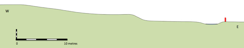
Fig. 31 Terracing in Paddock, profile 2.
Fig. 31 Terracing in Paddock, profile 2.
Fig. 32 Wormleighton Park 1634 survey, inset showing detail of perimeter earthwork overlying earlier ridge and furrow.
The hall’s earliest architectural features are on the west front which probably dates from around 1700. Some thick internal walls indicate the possibility of an earlier house encased in the eighteenth-century construction (Haworth 1999: 16). A large pile of stonework behind the estate yard derives from the demolition of the service wing in the 1930s (Haworth 1999: 19). This shows evidence for a stone building of massive construction with stone mullions that would not be out of place on a major building of the early seventeenth century. Enclosures of the early 1600s could have gone hand in hand with the removal of the hall from its previous moated site to the rather drier location to the west, with improved prospects in both senses of the word.
Discussion
This analysis of the creation of the seventeenth-century park is largely based on conjecture, drawing together the facts about enclosure and the topographical evidence. However, if we accept this development as likely a number of consequences followed on for the locals. The turmoil occasioned by early enclosure is well documented and commented on. In many cases the attractions of sheep farming lead the drive to early enclosure. At Wormleighton the Spencer family had five shepherds looking after 10,000 sheep (Stocker 2006:82) partly on land formerly part of the village. Although peasant uprisings were not common, 45 outbreaks of rioting were recorded in England between 1585 and 1660 (Walter and Wrightson 1976: 26). There were a series of anti-enclosure riots known as the Midland Rising of 1607 which ended in a pitched battle at Newton in Rockingham Forest. During the course of this around 1,000 Levellers were driven off and some 50 dispatched on the spot. These instances of ‘rebellions of the belly’ (Hindle 2003: 137) occasionally resulted in direct attacks on the grand houses.
We have no indication of any unrest at Farnborough, but it is difficult to imagine that radical changes went unremarked. The customary patterns of rights, duties and obligations linked to usage of mills and fishponds must have been subject to change following the creation of the park. Of further significance was the exclusion of the community from access to St. Botolph’s Well (Fig. 33). The arrangement of church, holy well and connecting thoroughfare was probably an ancient one which reflected the communal use of this spring for practical and spiritual purposes. What is striking today about the spatial relationship is that the seventeenth-century park wall cuts across the bottom of the former route and effectively restricts access to the well as it is now on private property.
A door in the wall, which by analogy to other local properties, appears to be eighteenth century (Wood-Jones 1963), was provided to allow some access. This door could only be opened from the park side. Even allowing for the fact that the Reformation brought about a divorce between the established church and the idolatrous practice of visiting a holy well one must assume that on some level of superstition the well still occupied an important part in the community’s consciousness. What was communal has become private.
Fig. 33 St. Botolph’s church and well, from south-west (Photo CM).
The Holbech family belonged to that category of English landowners often described as country gentry, members of a broad spread of second ranking elite, below the comparatively small number of peers but above the numerous ranks of those engaged in trade (Cannon 1987:10). The Holbechs would find themselves somewhere within the spectrum described by Corfield (1996: 4) ‘At the upper end of the scale, the gentry included the younger branches of the nobility… at the lower end of the scale, the status of the lesser gentlemen tailed away into the ranks of the substantial freeholders or yeomanry’.
There are some problems in writing an historical outline of the Holbechs of Farnborough. All four major published accounts are essentially the same (Nares 1954, Haworth 1999. Meir 2006 and Ince 2011) and refer back ultimately to ‘family tradition’. Holdings in the Warwickshire County Record Office include several boxes of papers including: surveys and plans (WCROL1); estate and household accounts for 1813-94 and a scrapbook containing miscellaneous correspondence (WCROCR 656); and estate and household accounts for the years 1771-1782, 1791-1796,1810-1812 (WCROCR 1799). Valuable as these are for understanding subsequent management of the estate, they offer no coverage of the crucial years when the park was under development.
The family originated in Lincolnshire but moved to Fillongley, Warwickshire in the fifteenth century and rose to prominence within the county over the next two hundred years. Ambrose Holbech (1596 – 1662) settled in Mollington, a parish adjacent to Farnborough, in 1629. His son, also named Ambrose, became a lawyer who, according to his monument in Mollington Church was, ’very eminent in ye Law… which he practiced with great integrity’. He clearly had some influential contacts, marrying his daughter Sarah to Sir Thomas Powys who became solicitor-general in 1686. In 1684 Ambrose purchased the estate at Farnborough from the executors of the Ralegh family. Nares (1954) notes that the estate was ’much encumbered’ and that only £2,260 out of the total purchase price of £8,700 was paid, the remainder having been advanced by Ambrose as a mortgage on the property. Work on the house and grounds was begun by Ambrose’s son William who in 1692 married an heiress, Elizabeth Alington, but it was their son William, who succeeded his father in 1717, who was responsible for the main changes (Ince 2011: 85 to 88).
The family tell the story that William was ‘disappointed in love’ and around 1724 he departed for Italy, where he lived for over a decade. Upon his return he brought with him paintings and classical sculptures which established his reputation as a connoisseur. Early in the 1740s work began on remodeling the house and park with a strong emphasis on the classical. In the house paintings by Canaletto and Panini were hung amidst elaborate Rococo plasterwork (Fig. 35). About the park no less than four buildings were erected in the classical style. These were associated with the construction of a huge terraced walk running south from the hall (Fig. 39) and were: the Game Larder (Fig. 92), the Ionic Temple (Fig. 38), the Oval Temple (Fig. 40) and the Pentagonal Temple, now lost beneath a nineteenth-century cistern. In addition an obelisk (Fig. 34) was stationed at the end of the terrace walk completed in 1751. William never married and continued to supervise his estate until his death in 1771.
Fig. 34 The Obelisk 1752, from south-west (Photo VW).
His nephew, also named William, took over the house and garden and one of his first acts was to commission a detailed survey of the property by Edward Linnell ( Linnell 1772). This consists of a series of detailed maps, often of individual fields and is of enormous value in understanding the work carried out earlier in the century. William died in 1812 and the property was inherited by another William ( 1774 – 1856). The new incumbent was responsible for developing the estate in association with the architect Henry Hakewill (English Heritage 2011). A further lengthy period ensued until the house and park passed to William’s third son Charles (1816 – 1901) in 1856. Charles took holy orders, became archdeacon of Coventry and, as well as spending large amounts of money on restoring the church, also built a new road that linked the village with Avon Dassett to the north-west. In 1901 the inheritance passed to his grandson William (1882 – 1914) who died during the First World war whilst serving with the Scots Guards. His brother Ronald (1887 – 1956) took the property on and it should have passed to his son Edward (1917 – 1945) but he died in an accident on VJ day. Subsequently a settlement was made and Geoffrey (1919 - ), Edward’s brother, inherited the estate. Much of it was sold off in 1948 following damage by serious gales in the previous year and in 1960 the remaining property, including several residences in the village, passed to the National Trust in lieu of death duties.
Discussion
A number of key questions remain unanswered by the historic record, most notably queries linked to the work done by the Holbechs towards the end of the seventeenth and into the eighteenth century. First amongst these is how was it planned and what did it cost? We also need to understand how the work was carried out. Further questions relate to how the park was used and ultimately, what was its purpose? In the absence of relevant documentation we will need to turn to the archaeology of the park for partial answers to some of the questions, as they relate to the use and management of water resources.
Fig. 35 Farnborough Hall, roof repairs, October 2011.
One of the difficulties in understanding the design of the park is that we have no direct evidence for the involvement of one of the main protagonists. Meir (2006: 2) explains that the problems in studying Miller are, ‘partly due to the fact that, as a gentlemen, Miller declined to ask for fees, consequently no bills were sent out for his work… it appears that detailed architectural drawings were left to the master masons and craftsmen who worked for him’. The Warwickshire County Record Office holds most of the primary source material relating to Miller. This includes a huge amount of received correspondence and an incomplete set of account books (CR125B/) and two diaries from 1749 to 1750 (CR1382/1) and 1756 to 1757 (CR 1382/32), which have been edited and published (Hawkes 2005).
Sanderson Miller (Fig. 3) was born in 1716 at Radway, Warwickshire in the house that was to become his lifelong home and which lies just four miles to the west of Farnborough. He studied at Oxford’s Saint Mary Hall as a ‘gentleman commoner’ in 1734. It is clear from the contacts he maintained through his later life that he developed an extensive circle of friends and acquaintances there, many of them from the higher echelons of society (Hawkes 2005:6). He returned to Radway in 1737 upon the death of his father and immersed himself in the administration of the estate. Miller’s interest in architecture and landscaping had grown throughout his time at Oxford and he had been particularly inspired by visits to the Temple family and their gardens at Stowe, Buckinghamshire (Meir 2006:9). His inheritance of the estate enabled him during the late 1730s and early 40s to develop his ideas on landscape architecture in a kind of self-administered apprenticeship. He erected a tower above Edge Hill (Fig. 36), based on Guys Tower at Warwick Castle and built a series of pools, cascades and fountains running down the escarpment. His evident talent, easy and obliging manner and active social life began to win him not only admirers but patrons who were keen to solicit his advice on improvements to their own properties. Most of his early work, up until around 1745, was undertaken close to home: Upton House and Honington Hall, Warwickshire and Wroxton Abbey and Ambroseden House , Oxfordshire (Hawkes 2005: 391 to 398).
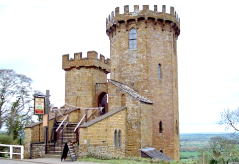
His work at Farnborough probably began around 1745 and continued into the early 1750s (Hawkes 2005: 393). The evidence for this rests primarily on the word of his great-grandson who wrote towards the end of the nineteenth century, ‘… in these works Mr. Holbech was assisted by the advice of his friend and neighbour Sanderson Miller of Radway.’ (Miller 1900: 61). The fact that the Warwick mason William Hiorns was employed both at Radway and Farnborough suggests another a link (Meir 2006: 239 ) and a friendship between Miller and Holbech is maintained both by family tradition and evidence from the diaries of frequent visits, for example, on June 29th. 1743, ‘Went with wife, brother and sister Trotman to dine with Mr. Holbech at Farnborough. Mr. Bolton there. Drank tea in the summer-house. Came home by moon-light’ (Hawkes 2005: 88).
Miller’s early work grew out of a period when attitudes to garden design were rapidly changing. The formality of late seventeenth-century gardens with their square, box-like planting and rigid lines of terracing was giving way to a style which began, in the 1720s, to approximate to something more ‘natural’. What was significant about this period was that there was no agreed formula for a successful naturalistic garden, we are still a quarter of a century away from Lancelot ‘Capability’ Brown’s dominance. The work of designers such as Stephen Switzer, Charles Bridgeman and William Kent could legitimately be described as experimental and ferment in the gardens went hand in hand with the eclectic approach to architecture known as Rococo (Mowl and James 2011: 91). Miller’s input into this was heavily influenced by his interest in the gothic, indeed he has in recent years been increasingly recognised as a pioneer of the gothic revival (Mowl 2006) .
Meir (2006: 55) indicates that Miller’s experiences at Radway not only involved the construction of elaborate waterworks, but also the practicalities of draining land to make it fit for agriculture.
The tradition of hydraulic engineering was in a decline after the excesses of the previous century’s elaborate water parterres, grotesque fountains and ‘houses of diversion’ (Strong 1998: 167 to 199), but clearly Miller saw the possibilities for enhancing the landscape with pools, cascades and possibly his trademark: long sinuous waterways. Evidence for his involvement in the kind of large scale civil engineering projects we envisage at Farnborough is even rarer than for his designs for standing buildings. However, a pattern does emerge from the projects he was credited with and, as Meir (2006: 217 -219) contends, one may, perhaps, build up a feel for his style in landscaping.
Miller’s career continued into the second half of the eighteenth century. One of his major architectural achievements was the design of Hagley Hall, Worcestershire for George Lyttleton between 1756 and 1760. Work at Hagley also included the hugely influential ‘ruined castle’ begun in 1747 (Symes and Haynes 2010: 123). Miller’s other major building was the Shire Hall at Warwick designed around 1753 (Meir 2006:177) and boasting a Palladian façade (Fig. 37). Towards the end of his life Miller suffered from a series of mental breakdowns. He had been subject to bouts of depression for much of his life and was confined in a number of establishments from 1757, finally dying in Dr. Duffield’s Asylum in Little Chelsea in 1780 (Hawkes 2005: 72).
One of the difficulties in understanding the design of the park is that we have no direct evidence for the involvement of one of the main protagonists. Meir (2006: 2) explains that the problems in studying Miller are, ‘partly due to the fact that, as a gentlemen, Miller declined to ask for fees, consequently no bills were sent out for his work… it appears that detailed architectural drawings were left to the master masons and craftsmen who worked for him’. The Warwickshire County Record Office holds most of the primary source material relating to Miller. This includes a huge amount of received correspondence and an incomplete set of account books (CR125B/) and two diaries from 1749 to 1750 (CR1382/1) and 1756 to 1757 (CR 1382/32), which have been edited and published (Hawkes 2005).
Sanderson Miller (Fig. 3) was born in 1716 at Radway, Warwickshire in the house that was to become his lifelong home and which lies just four miles to the west of Farnborough. He studied at Oxford’s Saint Mary Hall as a ‘gentleman commoner’ in 1734. It is clear from the contacts he maintained through his later life that he developed an extensive circle of friends and acquaintances there, many of them from the higher echelons of society (Hawkes 2005:6). He returned to Radway in 1737 upon the death of his father and immersed himself in the administration of the estate. Miller’s interest in architecture and landscaping had grown throughout his time at Oxford and he had been particularly inspired by visits to the Temple family and their gardens at Stowe, Buckinghamshire (Meir 2006:9). His inheritance of the estate enabled him during the late 1730s and early 40s to develop his ideas on landscape architecture in a kind of self-administered apprenticeship. He erected a tower above Edge Hill (Fig. 36), based on Guys Tower at Warwick Castle and built a series of pools, cascades and fountains running down the escarpment. His evident talent, easy and obliging manner and active social life began to win him not only admirers but patrons who were keen to solicit his advice on improvements to their own properties. Most of his early work, up until around 1745, was undertaken close to home: Upton House and Honington Hall, Warwickshire and Wroxton Abbey and Ambroseden House , Oxfordshire (Hawkes 2005: 391 to 398).
Fig. 36 Castle Tower, Edgehill, from south-east.
His work at Farnborough probably began around 1745 and continued into the early 1750s (Hawkes 2005: 393). The evidence for this rests primarily on the word of his great-grandson who wrote towards the end of the nineteenth century, ‘… in these works Mr. Holbech was assisted by the advice of his friend and neighbour Sanderson Miller of Radway.’ (Miller 1900: 61). The fact that the Warwick mason William Hiorns was employed both at Radway and Farnborough suggests another a link (Meir 2006: 239 ) and a friendship between Miller and Holbech is maintained both by family tradition and evidence from the diaries of frequent visits, for example, on June 29th. 1743, ‘Went with wife, brother and sister Trotman to dine with Mr. Holbech at Farnborough. Mr. Bolton there. Drank tea in the summer-house. Came home by moon-light’ (Hawkes 2005: 88).
Miller’s early work grew out of a period when attitudes to garden design were rapidly changing. The formality of late seventeenth-century gardens with their square, box-like planting and rigid lines of terracing was giving way to a style which began, in the 1720s, to approximate to something more ‘natural’. What was significant about this period was that there was no agreed formula for a successful naturalistic garden, we are still a quarter of a century away from Lancelot ‘Capability’ Brown’s dominance. The work of designers such as Stephen Switzer, Charles Bridgeman and William Kent could legitimately be described as experimental and ferment in the gardens went hand in hand with the eclectic approach to architecture known as Rococo (Mowl and James 2011: 91). Miller’s input into this was heavily influenced by his interest in the gothic, indeed he has in recent years been increasingly recognised as a pioneer of the gothic revival (Mowl 2006) .
Meir (2006: 55) indicates that Miller’s experiences at Radway not only involved the construction of elaborate waterworks, but also the practicalities of draining land to make it fit for agriculture.
The tradition of hydraulic engineering was in a decline after the excesses of the previous century’s elaborate water parterres, grotesque fountains and ‘houses of diversion’ (Strong 1998: 167 to 199), but clearly Miller saw the possibilities for enhancing the landscape with pools, cascades and possibly his trademark: long sinuous waterways. Evidence for his involvement in the kind of large scale civil engineering projects we envisage at Farnborough is even rarer than for his designs for standing buildings. However, a pattern does emerge from the projects he was credited with and, as Meir (2006: 217 -219) contends, one may, perhaps, build up a feel for his style in landscaping.
Miller’s career continued into the second half of the eighteenth century. One of his major architectural achievements was the design of Hagley Hall, Worcestershire for George Lyttleton between 1756 and 1760. Work at Hagley also included the hugely influential ‘ruined castle’ begun in 1747 (Symes and Haynes 2010: 123). Miller’s other major building was the Shire Hall at Warwick designed around 1753 (Meir 2006:177) and boasting a Palladian façade (Fig. 37). Towards the end of his life Miller suffered from a series of mental breakdowns. He had been subject to bouts of depression for much of his life and was confined in a number of establishments from 1757, finally dying in Dr. Duffield’s Asylum in Little Chelsea in 1780 (Hawkes 2005: 72).
Fig. 37 Warwick, Shire Hall, from south-east.
The hall, as improved from 1692 onwards, is set on an elevated tongue of land flanked to the north by a valley which separates it from the village and to the south by the abrupt line of the Cotswold escarpment. To the west there were views towards the open fields of neighbouring villages, Edge Hill and ultimately the broad plain of the River Avon. The location would have been airy yet sheltered from the cold north-easterly winds and it would, perhaps above all, have been well drained.
The Terraces and Temples
The eighteenth century park clearly revolves around the hall although its exact layout is precisely adapted to the immediate topography. To the south, stretching some three quarters of a mile (1,200 metres), runs the park’s best known feature, the south terrace. This remarkable structure is tucked just below the crest of the hill and is on three levels, the lowest being retained by a dry stone wall and the whole given a wavy edge reminiscent of a whole chain of shallow semi-circular bastions. The turfed walk along the terrace was enlivened by the provision of a variety of structures set at roughly 200 yard (180 metre) intervals. The first of these is the hexagonal game larder (Fig. 92) with a covered seat framed by classical detailing offering views out across the old park towards the church (Fig. 71). Beyond this is the Ionic Temple (Fig.38), four columns supporting a pediment and sheltering a loggia with appropriate seating. This gives a panorama from the north-west to the south-west and offers the best view of the park’s eighteenth-century water features.
Next in line is the rather top heavy Oval temple (Fig. 39) with an enclosed first floor room and an open ground floor loggia with built in table and bench. Passing round the next bend opens up the prospect of the obelisk (Fig. 34). Earthwork evidence indicates that the terracing continued beyond its present day extent curving round to the east as it approached the site of the lost pentagonal temple.
There are also earthworks for a northern terrace walk which took in two planting or possibly prospect mounds and ultimately headed for the former mill mound, converted for planting in the eighteenth century. This was accompanied by an additional approach: a carriage drive terraced into the north slope of Windmill Hill affording visitors the optimal sequence of views as they drew nearer to the hall (Meir 2006: 89).
What is evident to anyone who walks in the park today is that whilst terraced walks with their buildings and plantings are important element, the whole plan actually pivots on the new water features added in the eighteenth century, a point that would have been even more obvious before the nineteenth-century schemes of planting were undertaken.
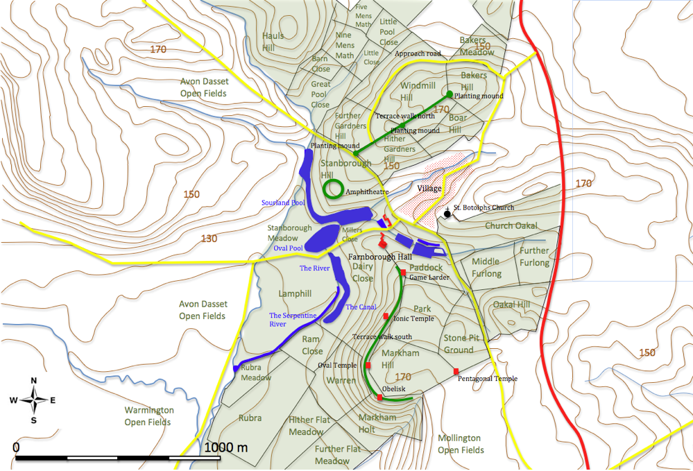
Sourland Pond
Although some remodeling may have been carried out on earlier ponds in the Paddock, the pools and cascades to the west of the hall, which saw the main thrust of the work, represent constructions which were not only novel in appearance but large in scale and ambition. The first in this chain of associated waterworks is Sourland Pond (Fig. 41), so named because it partially occupied ground that was poorly drained and uncultivable. Its curious position converts Stanborough Hill into a cape by wrapping round the 135 metre contour to create a crescentic lake (Fig. 42). What makes Sourland Pond remarkable is that only the southern portion is contained by the natural lie of the land; the northern section, roughly 200 metres long, is held against the face of the hill by a huge earth dam like the one used to construct the Oval Pond.
A number of small streams had supplied the Great Pool (Fig. 19), but its dam was breached and the water redirected into Sourland Pond. A small stream which drains the valley to the north of the church runs into its southern end. The third source approaches in a stone lined culvert from the south-east (Figs. 43 and 44) originating at a sluice gate set in the brick northern margin of the Lady Pool. It once filled the Pond in Middle Close but now runs directly into Sourland Pond.
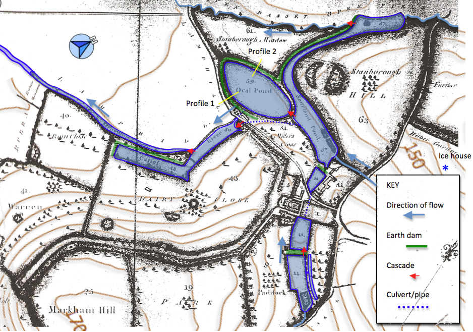
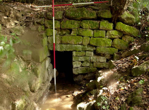
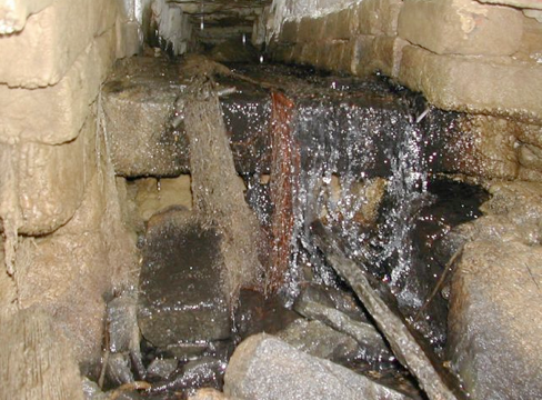
The culvert is substantially built with dressed stone blocks. Some 1.5 metres in from the outflow there is a sudden rise in the level of the culvert floor of 70 centimetres, a device to avoid blockages by accumulated debris (Fig. 44) and to diminish the force of the water (Chanson 2000). The method of construction together with the fact that it runs under a seventeenth-century barn suggests a pre-Georgian date.
At Sourland Pond’s northern end is a spillway which takes water over the face of a dam and feeds a small stream which runs off to the south, a continuation of the stream which fed the pool from the north. A spillway and cascade took water from the southern edge of Sourland Pond into the Oval Pond. This must have been quite an impressive structure (Fig. 45) but is now in poor condition, It was repaired in 1939 with steel shuttering, bricks and concrete (Cherry 2011).
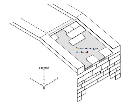
Since then water has undercut the sloping stone slabs causing many of then to collapse into a void underneath. The height of the cascade is significant in enabling an estimate to be made of the depth of water in the Oval Pond. Finally a modern concrete retaining wall and grill marks the start of a siphon like pipe which takes water to the top of the Cascade on the other side of the present road (Fig. 46).
The Oval Pond
The Oval Pond lies next to the southern margin of the Sourland Pond and shares its perimeter for around 100 metres. Although now drained the surviving earthworks indicate that this was an extraordinary piece of civil-engineering (Fig. 46) for which it has proved difficult to find parallels.
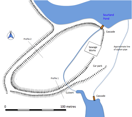
It is unclear when the Oval Pond was emptied. There were several mature trees on the dam; tree ring counts show them to have been planted in the second decade of the nineteenth century. As this planting is only within the top couple of metres of the dam’s inner face we can assume the pond still contained water. On the 1882 OS map the area is shown wooded and labeled ‘fox covert’. It is possible that the pond was drained specifically to create cover for game although one suspects that the cost of maintenance and repair may also have played a part. A network of shallow drainage ditches across the bottom of the former pond demonstrates a need to thoroughly dry out the site prior to further use. The surviving earthworks are in good condition overall, although damaged on the south side by the construction of a sewage treatment plant and modified by the creation of a car park next to it. The line of the dam to the south-west is obscured by generations of tipping of building and garden waste from the estate. A shallow ramp has been constructed at this end to facilitate the process.
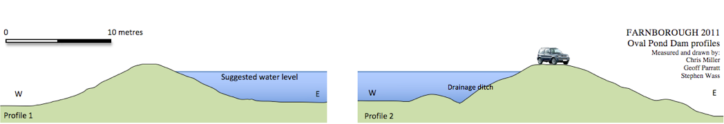
The Cascade, River and Canal.
South of the Oval Pond an elongated body of water named is fed by culvert from the Oval Pond and by water taken from Sourland Pond to supply the Cascade. The Cascade is set against the south face of an artificial mound (Wass 2011b) retained by dry-stone walled terraces (Fig. 49). It was carefully constructed to achieve a number of effects. The water empties into a rectangular stone basin covered with a large capstone at the summit of the mound. It then spills over a series of steep narrow steps which are interrupted at two points by stone slabs with semi-circular grooves in their top faces and sockets for some kind of fitting along the top outer edge. The flow is then modified by passing it over four broad shallow steps, where the water is only ever a couple of centimetres deep, before emptying into the lake (Fig. 50).
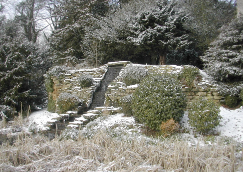
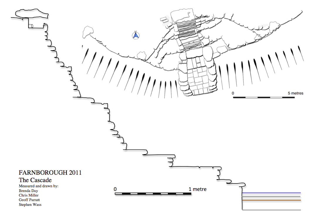
The River (Fig. 51) is shown on the 1772 map as a slightly curving body of water set into a natural declivity between Dairy Close and Lamp Hill (Fig. 42). Its present margins have spread considerably as a result of damage by livestock. At its southern end there is a bend to the south-west into an attached body of water known as the Canal (Fig. 52) presumably because of its regular outline, although again some of this has been softened by erosion.
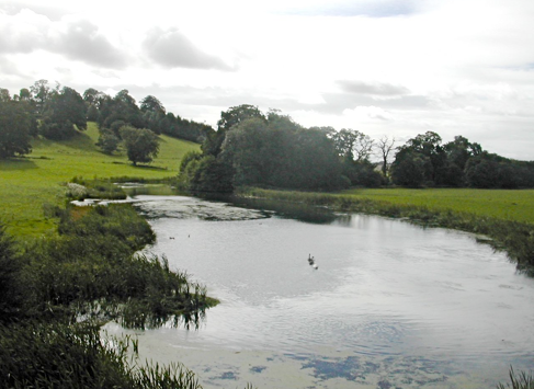
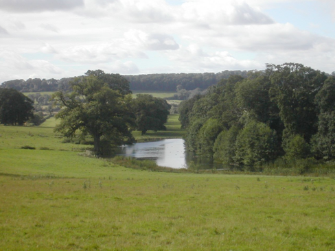
The Canal is defined by a large ‘L’ shaped dam which holds it against the contour to the west and closes the valley to the south (Fig. 53). The dam, planted and named The Rookery, was connected to the pasture below the hall by a footbridge. Along its western side, although at a considerably lower level, was the final major water feature of the park, the Serpentine River.
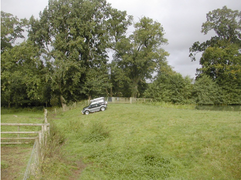
The Serpentine River
In a remarkable landscape the final extraordinary element in the composition is labeled on the 1772 map as the Serpentine River. It originates at a large sluice, almost entirely rebuilt in the twentieth century, that lies to the west of the junction between the River and the Canal. It consists of the canalized course of a natural stream that runs for a distance of around 750 metres to the south-west (Fig. 54). The water level was originally maintained by four further sluices. These are constructions of considerable sophistication and whilst sharing a common purpose are by no means uniform in their details. All have been repaired and modified at various times and are currently in a very poor state of preservation and at risk of further deterioration.
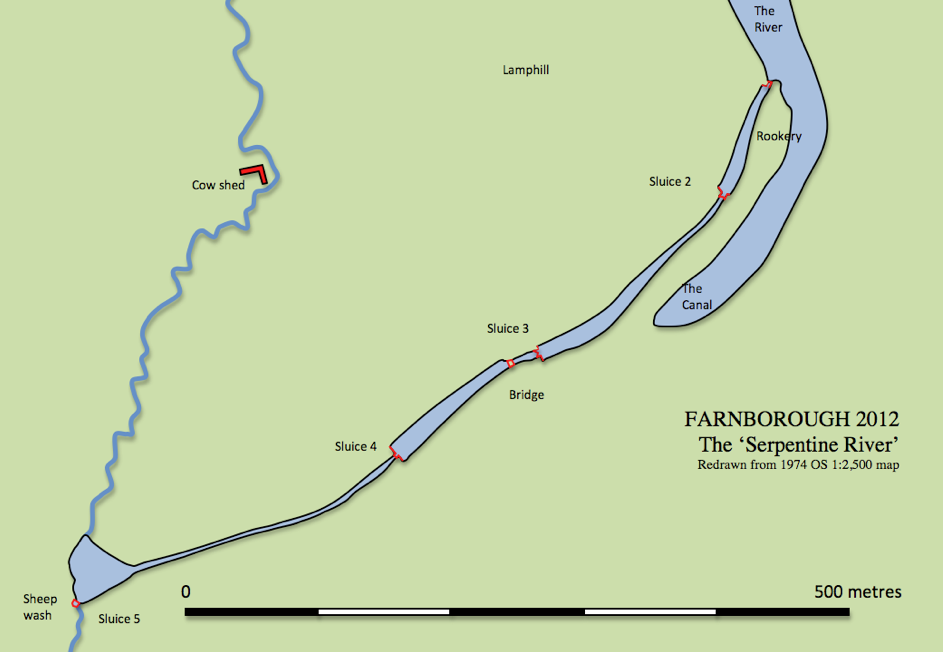
Sluice 2, typically, consists of two brick and stone piers (Figs. 55 and 56). The bottom of the channel is lined with timber although downstream there is an edging of large stone slabs. The position of a timber mitre gate is shown by the angled rebate set into the inner face of the east pier. The west pier is in a particularly ruinous state.
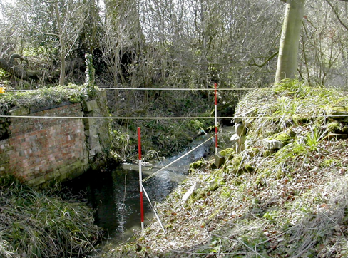
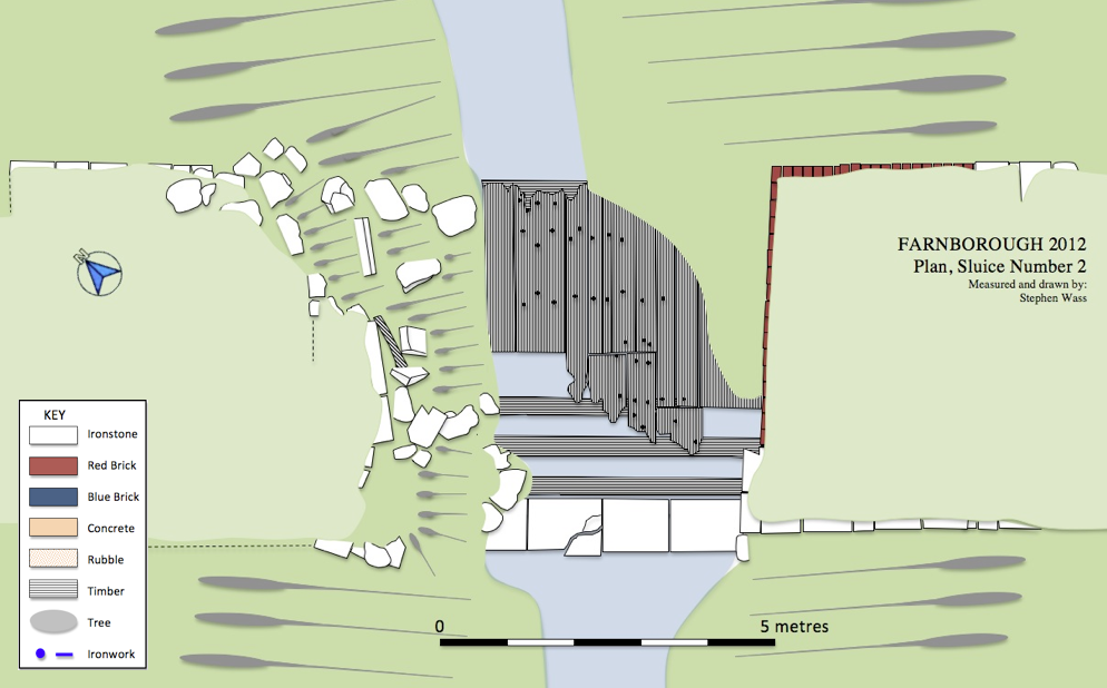
150 metres downstream is sluice 3 with a similar arrangement of largely intact brick and stone piers. One important difference is that the downstream walls of these piers are clearly meant to be seen and enjoyed as a decorative feature. The wall is made of well dressed stone with elegant curving terminals to each face (Fig. 57). Around 20 metres beyond this is a brick bridge wide enough to carry a cart or carriage. The water passes below through two brick lined culverts. As this feature is not on the 1772 map it presumably belongs to the improvements made in the early nineteenth century.
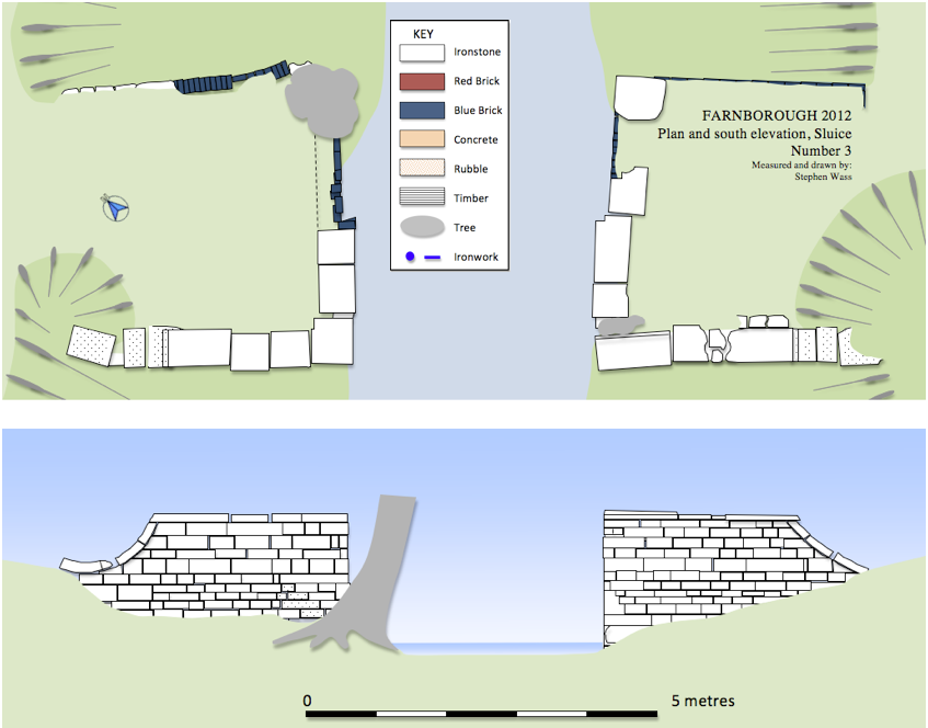
Sluice 4, 200 metres further to the south-west, is different in that it contains a small cascade (Fig. 58). Work on comparative levels demonstrates that this feature was designed to be visible (Fig. 76 ). The spillway above the cascade is formed from well dressed and laid stone slabs. At some point in the twentieth century the timber gates were replaced by a barrier of reinforced concrete which clearly echoed their shape (Fig. 59).
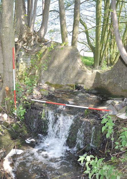
The concrete walling is in the form of a shallow ‘V’ pointing up stream with the ends anchored in the angled rebates also seen in sluices 2 and 3. A small rectangular opening, once closed by a paddle, enabled the water behind the sluice to be emptied. A local informant reported that the large gap was blown in the concrete shortly after the Second World War using army surplus explosives. A decision was clearly taken that whatever the Serpentine River’s original function was, the upkeep was too demanding and water should be allowed to revert to its natural course. The same informant also indicated that lowering the water level improved the drainage and hence the cropping in the adjacent fields.
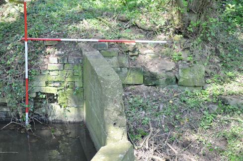
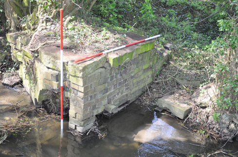
The final sluice, number 5 is the most complex and incorporates a later sheep wash (Fig. 61). It marks the point where the water of the Serpentine River meets the stream from the north end of Sourland Pond and then leaves the park to join the River Cherwell near Banbury. Sluice 5 adopts the same basic layout as the others; like sluice 4 it has a later concrete barrier (Fig. 60) and like sluice 2 the bottom is partially boarded. Post-1772 two smaller piers were built a little down stream with rebates into which boards could be slotted to create a temporary pool behind the main sluice gates (Fig. 61). A rough flight of steps was made using blocks from the west pier to enable the sheep to scramble out after having been thrown in from the sluice’s east pier. The practice of sheep washing here was abandoned shortly after the Second World War (Pick 2012). It can be viewed as a ‘rough and ready’ version of the kind of facility built in the nearby village of Warmington (Fig. 63). North of sluice 5 a low terrace running roughly east–west marks the position of a triangular pond which was mapped in 1772 and formed a conclusion to the Serpentine River.
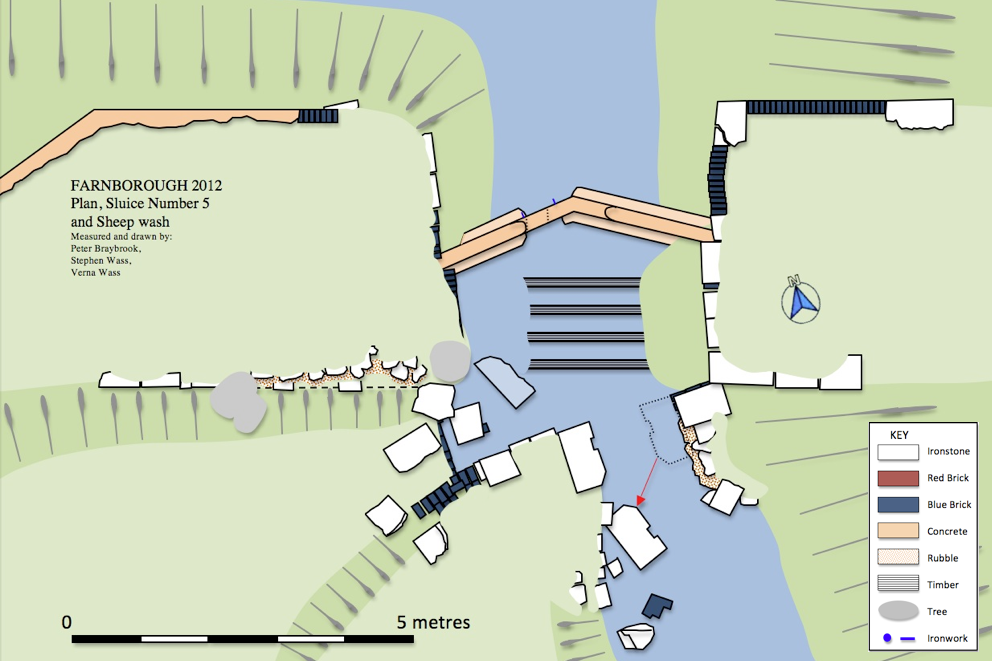
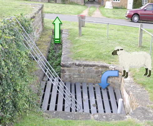
The Amphitheatre
Although not a water feature this unusual construction clearly figured in the Georgian landscape using Sourland Pond as a framing device for Stanborough Hill and this earthwork which crowned it. Although the outline of the amphitheatre is clearly visible on the 1772 map as an area of planting on an otherwise bare hillside, the significance of the huge earthwork which underpinned this was neither recognised nor recorded until this current investigation.
The earthwork (Figs. 64 and 66) consists of a massive crescentic bank (Fig. 67) up to 8 metres high backed by a curving ditch and fronting onto a large level terrace. Beyond this to the south-west the natural fall of the land reasserts itself and the enclosure is completed by a further curving ditch towards the foot of the slope (Fig. 68). In the context of English landscaped garden design in the seventeenth and eighteenth centuries an amphitheatre was a circular or semicircular feature defined by terraces and occasionally banks and ditches. It could be a place for special planting, to be admitted from a distance, or a venue to which one walked for the view. They derived from a number of well known Italian Renaissance examples. The earlier ones, as at Wilton House, Wiltshire may also have seen performances of the kinds of outdoor masques and pageants which were popular in the seventeenth century. The amphitheatre at Wilton, now destroyed, was designed by Salomon de Caus for Philip Herbert, Fourth earl of Pembroke, in the 1630s (Strong 1998: 147) This paved the way for Charles Bridgeman’s work at Claremont, Surrey (Fig. 65) around 1715 ( Mowl 2010:69) and Lord Burlington’s orange garden at Chiswick in the late 1720s (White 2010:28) both of which were closely associated with water. Despite recent archaeological investigations (Wass 2012c) the question of dating at Farnborough is unresolved so there remains the possibility that this earthwork is an earlier feature adapted for planting.
.
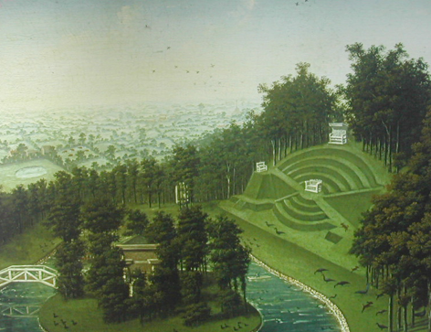
Discussion
Yentsch and Kratzer (1994: 181) suggest that, ‘the key steps towards understanding the spatial relationships utilized within a garden’s design are (1) establishing its boundaries, (2) finding its major axis and (3) locating other passageways through it’. This analysis works well for formal gardens, but in the context of planning at Farnborough we see Miller and Holbech making early, if not pioneering, use of the borrowed landscape. This process was aided by the invention of the sunken fence or ha-ha, generally attributed to the garden designer Charles Bridgeman working in the early decades of the eighteenth century ( Fleming and Gore 1979: 91). By adopting the surrounding countryside and, with the agreement of neighbouring landowners, carrying out additional planting of specimen trees they were able to create a garden that visually had no boundaries.
In terms of the park’s major axes it is evident that spatial arrangements including the location of water features were strongly influenced by the location and orientation of the hall (Fig. 70). The main entry to the hall is from the north-east (Fig. 2) where there is a limited prospect down the drive towards the village. There is no view at all to the south-east as this side was occupied by the hall’s service block. However, the views to the north-west and south-west were impressive in their ambition and effect.
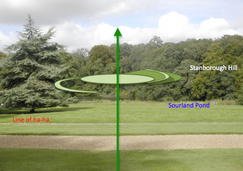
It is difficult to capture the original view to the north-west because of the early nineteenth-century planting which turned Stanborough Hill into an arboretum. Much admired as the view is today, with mature trees mirrored in the pool’s surface, it surely cannot compare with the extraordinary effect the sculptural form of the amphitheatre would have had viewed across the water (Fig. 69). The slopes of Stanborough Hill were grassed over as was the central terrace of the amphitheatre whilst planting on the banks in 1772 was labeled as shrubbery.
Examination of surviving tree stumps shows that the top of the inner scarp of the lower ditch was lined with yews, but the overall aspect would have remained a very open one. As the spectator walked towards the edge of the ha-ha another extraordinary effect would have been revealed. To the west the full extent of the Oval Pond appeared jutting out towards the open fields in a way somewhat reminiscent of the modern ‘infinity pool’.
The outlook to the south-west passed over neatly cropped lawn to pasture, with the obligatory ha-ha separating the two, then along the entire length of the Canal before the line was picked by an avenue of oaks which ran for over half a mile (900 metres). The view today is broadly similar although the trees in the avenue have been replanted and the canal has lost some of its regularity. Again the effect is a clever one as the retaining dam remains largely invisible from the hall.
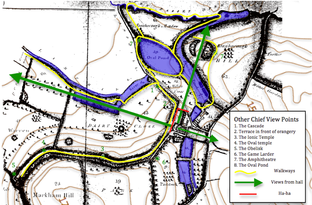
The existence of other view points can be assumed, either from the presence of buildings incorporating seating, or from other striking features in the landscape (Fig. 70). In nearly all cases water forms a significant part of the prospect. With the view from the game larder across the old Jacobean park and stew ponds to the church (Fig. 71) one could reflect on the landscape’s historic dimension whilst looking out from the top of the Cascade and the walk that approaches it the visitor could enjoy the naturalistic curve of the River (Fig. 51).
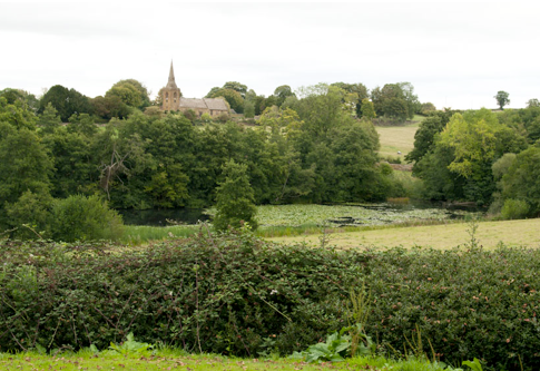
The third component to this analysis of aspects of the park’s layout is the way in which passageways were effected through the landscape linking together the various elements. At Farnborough, as was the case in many early eighteenth-century gardens, hard paving seems to have been the exception rather than the rule.
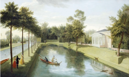
As the painting of the amphitheatre at Claremont ( Fig. 65) and Rysbrack’s images of the gardens at Chiswick show, visitors were expected to explore the amphitheatres, enjoy the pools and admire the statues, by walking on the grass (Fig. 72). Farnborough has some designated routes as in the terrace walk and the yew walk down to the Cascade. Footbridges shown on the estate map also indicate walkways as does the presence of the broad flat tops to the dams. It is the presence of water that ties all this together, either in the walks conducted around the perimeters of the various ponds, or more ambitiously out along the line of the Serpentine River or down the brook that spills out across Stanborough Meadow (Fig. 70).
In summary the arrangement of the eighteenth-century park puts the hall and its occupants firmly at the centre of the composition, however, the strongest feature of its design is the virtuoso way in which large bodies of water are manipulated, reaching out into the landscape and creating special effects. The way in which water was used is notable both for originality of vision and sophisticated engineering. What is, however, particularly important is the way in which those water resources, already partially subsumed in the seventeenth century, are now entirely taken over and put to the service of the estate and its aesthetic pursuits. A landscape of pleasure has virtually monopolized the local supply of water.
The hall, as improved from 1692 onwards, is set on an elevated tongue of land flanked to the north by a valley which separates it from the village and to the south by the abrupt line of the Cotswold escarpment. To the west there were views towards the open fields of neighbouring villages, Edge Hill and ultimately the broad plain of the River Avon. The location would have been airy yet sheltered from the cold north-easterly winds and it would, perhaps above all, have been well drained.
The Terraces and Temples
The eighteenth century park clearly revolves around the hall although its exact layout is precisely adapted to the immediate topography. To the south, stretching some three quarters of a mile (1,200 metres), runs the park’s best known feature, the south terrace. This remarkable structure is tucked just below the crest of the hill and is on three levels, the lowest being retained by a dry stone wall and the whole given a wavy edge reminiscent of a whole chain of shallow semi-circular bastions. The turfed walk along the terrace was enlivened by the provision of a variety of structures set at roughly 200 yard (180 metre) intervals. The first of these is the hexagonal game larder (Fig. 92) with a covered seat framed by classical detailing offering views out across the old park towards the church (Fig. 71). Beyond this is the Ionic Temple (Fig.38), four columns supporting a pediment and sheltering a loggia with appropriate seating. This gives a panorama from the north-west to the south-west and offers the best view of the park’s eighteenth-century water features.
Fig. 38 Ionic Temple, from west.
Next in line is the rather top heavy Oval temple (Fig. 39) with an enclosed first floor room and an open ground floor loggia with built in table and bench. Passing round the next bend opens up the prospect of the obelisk (Fig. 34). Earthwork evidence indicates that the terracing continued beyond its present day extent curving round to the east as it approached the site of the lost pentagonal temple.
There are also earthworks for a northern terrace walk which took in two planting or possibly prospect mounds and ultimately headed for the former mill mound, converted for planting in the eighteenth century. This was accompanied by an additional approach: a carriage drive terraced into the north slope of Windmill Hill affording visitors the optimal sequence of views as they drew nearer to the hall (Meir 2006: 89).
Fig. 39 The Oval Temple, from west.
What is evident to anyone who walks in the park today is that whilst terraced walks with their buildings and plantings are important element, the whole plan actually pivots on the new water features added in the eighteenth century, a point that would have been even more obvious before the nineteenth-century schemes of planting were undertaken.
Fig. 40 Eighteenth-century park, field names from Linnell (1772).
Sourland Pond
Although some remodeling may have been carried out on earlier ponds in the Paddock, the pools and cascades to the west of the hall, which saw the main thrust of the work, represent constructions which were not only novel in appearance but large in scale and ambition. The first in this chain of associated waterworks is Sourland Pond (Fig. 41), so named because it partially occupied ground that was poorly drained and uncultivable. Its curious position converts Stanborough Hill into a cape by wrapping round the 135 metre contour to create a crescentic lake (Fig. 42). What makes Sourland Pond remarkable is that only the southern portion is contained by the natural lie of the land; the northern section, roughly 200 metres long, is held against the face of the hill by a huge earth dam like the one used to construct the Oval Pond.
Fig. 41 Sourland Pond, from east.
A number of small streams had supplied the Great Pool (Fig. 19), but its dam was breached and the water redirected into Sourland Pond. A small stream which drains the valley to the north of the church runs into its southern end. The third source approaches in a stone lined culvert from the south-east (Figs. 43 and 44) originating at a sluice gate set in the brick northern margin of the Lady Pool. It once filled the Pond in Middle Close but now runs directly into Sourland Pond.
Fig. 42 Eighteenth-century waterworks (Linnell 1772), contours from OS 1:250,000 map.
Fig. 43 Outflow of culvert, from north-west (Photo CM).
Fig. 44 Inside of culvert, from north-west.
The culvert is substantially built with dressed stone blocks. Some 1.5 metres in from the outflow there is a sudden rise in the level of the culvert floor of 70 centimetres, a device to avoid blockages by accumulated debris (Fig. 44) and to diminish the force of the water (Chanson 2000). The method of construction together with the fact that it runs under a seventeenth-century barn suggests a pre-Georgian date.
At Sourland Pond’s northern end is a spillway which takes water over the face of a dam and feeds a small stream which runs off to the south, a continuation of the stream which fed the pool from the north. A spillway and cascade took water from the southern edge of Sourland Pond into the Oval Pond. This must have been quite an impressive structure (Fig. 45) but is now in poor condition, It was repaired in 1939 with steel shuttering, bricks and concrete (Cherry 2011).
Fig. 45 Spillway and cascade, reconstruction, isometric view from west.
Since then water has undercut the sloping stone slabs causing many of then to collapse into a void underneath. The height of the cascade is significant in enabling an estimate to be made of the depth of water in the Oval Pond. Finally a modern concrete retaining wall and grill marks the start of a siphon like pipe which takes water to the top of the Cascade on the other side of the present road (Fig. 46).
The Oval Pond
The Oval Pond lies next to the southern margin of the Sourland Pond and shares its perimeter for around 100 metres. Although now drained the surviving earthworks indicate that this was an extraordinary piece of civil-engineering (Fig. 46) for which it has proved difficult to find parallels.
Fig. 46 The Oval Pond, plan.
The
Oval Pond is a free-standing construction built out across the flat
valley bottom. Whilst normal practice was to create large pools by
damming a valley or excavating a depression, for three-quarters of its
circuit this pool is retained by a massive curving dam standing 5
metres high and having a base width of up to 20 metres (Fig. 47).
Examination of the spillway and cascade suggests that the water depth
was between 3 and 4 metres, this accords well with the fact that modern
reservoir engineers recommend a 'freeboard' of at least one metre,
although old ponds often make do with as little as 0.3 metres (Currie
et al 2003: 21). A walk way around the top of the dam (Fig. 48) links
to a path along the southern edge of Sourland Pond. The site is
currently drained through a brick lined culvert running under the road
and emptying into the River. We must assume that in the eighteenth
century this culvert was closed by some kind of sluice. It is unclear when the Oval Pond was emptied. There were several mature trees on the dam; tree ring counts show them to have been planted in the second decade of the nineteenth century. As this planting is only within the top couple of metres of the dam’s inner face we can assume the pond still contained water. On the 1882 OS map the area is shown wooded and labeled ‘fox covert’. It is possible that the pond was drained specifically to create cover for game although one suspects that the cost of maintenance and repair may also have played a part. A network of shallow drainage ditches across the bottom of the former pond demonstrates a need to thoroughly dry out the site prior to further use. The surviving earthworks are in good condition overall, although damaged on the south side by the construction of a sewage treatment plant and modified by the creation of a car park next to it. The line of the dam to the south-west is obscured by generations of tipping of building and garden waste from the estate. A shallow ramp has been constructed at this end to facilitate the process.
Fig. 47 The Oval Pond, earthwork profiles.
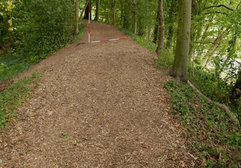
Fig. 48 Dam of Oval Pond, south side, from west (Photo CM).
The Cascade, River and Canal.
South of the Oval Pond an elongated body of water named is fed by culvert from the Oval Pond and by water taken from Sourland Pond to supply the Cascade. The Cascade is set against the south face of an artificial mound (Wass 2011b) retained by dry-stone walled terraces (Fig. 49). It was carefully constructed to achieve a number of effects. The water empties into a rectangular stone basin covered with a large capstone at the summit of the mound. It then spills over a series of steep narrow steps which are interrupted at two points by stone slabs with semi-circular grooves in their top faces and sockets for some kind of fitting along the top outer edge. The flow is then modified by passing it over four broad shallow steps, where the water is only ever a couple of centimetres deep, before emptying into the lake (Fig. 50).
Fig. 49 The Cascade, from south-east.
Fig 50. The Cascade, plan and section.
The River (Fig. 51) is shown on the 1772 map as a slightly curving body of water set into a natural declivity between Dairy Close and Lamp Hill (Fig. 42). Its present margins have spread considerably as a result of damage by livestock. At its southern end there is a bend to the south-west into an attached body of water known as the Canal (Fig. 52) presumably because of its regular outline, although again some of this has been softened by erosion.
Fig. 51 The River, looking south from summit of Cascade. Fig. 52 The Canal, looking south-west from terrace adjacent to hall.
The Canal is defined by a large ‘L’ shaped dam which holds it against the contour to the west and closes the valley to the south (Fig. 53). The dam, planted and named The Rookery, was connected to the pasture below the hall by a footbridge. Along its western side, although at a considerably lower level, was the final major water feature of the park, the Serpentine River.
Fig. 53 Dam, south of Canal, from east.
The Serpentine River
In a remarkable landscape the final extraordinary element in the composition is labeled on the 1772 map as the Serpentine River. It originates at a large sluice, almost entirely rebuilt in the twentieth century, that lies to the west of the junction between the River and the Canal. It consists of the canalized course of a natural stream that runs for a distance of around 750 metres to the south-west (Fig. 54). The water level was originally maintained by four further sluices. These are constructions of considerable sophistication and whilst sharing a common purpose are by no means uniform in their details. All have been repaired and modified at various times and are currently in a very poor state of preservation and at risk of further deterioration.
Fig. 54 The Serpentine River.
Sluice 2, typically, consists of two brick and stone piers (Figs. 55 and 56). The bottom of the channel is lined with timber although downstream there is an edging of large stone slabs. The position of a timber mitre gate is shown by the angled rebate set into the inner face of the east pier. The west pier is in a particularly ruinous state.
Fig. 55 Sluice 2, from north.
Fig. 56 Sluice 2, plan.
150 metres downstream is sluice 3 with a similar arrangement of largely intact brick and stone piers. One important difference is that the downstream walls of these piers are clearly meant to be seen and enjoyed as a decorative feature. The wall is made of well dressed stone with elegant curving terminals to each face (Fig. 57). Around 20 metres beyond this is a brick bridge wide enough to carry a cart or carriage. The water passes below through two brick lined culverts. As this feature is not on the 1772 map it presumably belongs to the improvements made in the early nineteenth century.
Fig. 57 Sluice 3, plan and elevation.
Sluice 4, 200 metres further to the south-west, is different in that it contains a small cascade (Fig. 58). Work on comparative levels demonstrates that this feature was designed to be visible (Fig. 76 ). The spillway above the cascade is formed from well dressed and laid stone slabs. At some point in the twentieth century the timber gates were replaced by a barrier of reinforced concrete which clearly echoed their shape (Fig. 59).
Fig. 58 Sluice 4, cascade and concrete barrier from south.
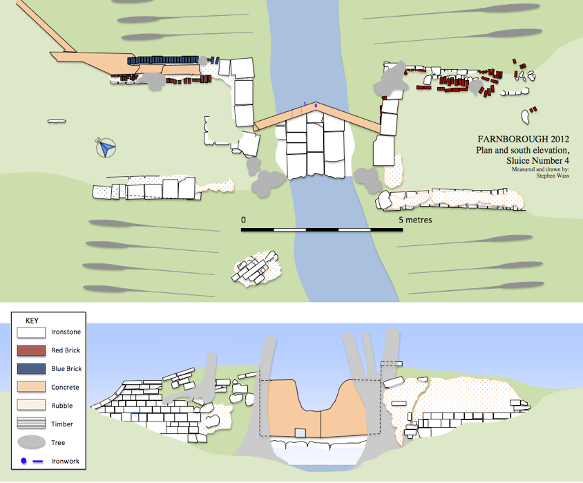
Fig. 59 Sluice 4, plan and elevation.
Fig. 59 Sluice 4, plan and elevation.
The concrete walling is in the form of a shallow ‘V’ pointing up stream with the ends anchored in the angled rebates also seen in sluices 2 and 3. A small rectangular opening, once closed by a paddle, enabled the water behind the sluice to be emptied. A local informant reported that the large gap was blown in the concrete shortly after the Second World War using army surplus explosives. A decision was clearly taken that whatever the Serpentine River’s original function was, the upkeep was too demanding and water should be allowed to revert to its natural course. The same informant also indicated that lowering the water level improved the drainage and hence the cropping in the adjacent fields.
Fig.
60 Sluice 5, west pier and concrete barrier, from east.
Fig. 61 Sluice 5, west pier of sheep wash and steps, from
north-east.
The final sluice, number 5 is the most complex and incorporates a later sheep wash (Fig. 61). It marks the point where the water of the Serpentine River meets the stream from the north end of Sourland Pond and then leaves the park to join the River Cherwell near Banbury. Sluice 5 adopts the same basic layout as the others; like sluice 4 it has a later concrete barrier (Fig. 60) and like sluice 2 the bottom is partially boarded. Post-1772 two smaller piers were built a little down stream with rebates into which boards could be slotted to create a temporary pool behind the main sluice gates (Fig. 61). A rough flight of steps was made using blocks from the west pier to enable the sheep to scramble out after having been thrown in from the sluice’s east pier. The practice of sheep washing here was abandoned shortly after the Second World War (Pick 2012). It can be viewed as a ‘rough and ready’ version of the kind of facility built in the nearby village of Warmington (Fig. 63). North of sluice 5 a low terrace running roughly east–west marks the position of a triangular pond which was mapped in 1772 and formed a conclusion to the Serpentine River.
Fig. 62 Sluice 5 and sheep wash, plan.
Fig. 63 Sheep wash at Warmington, from south (Photo VW).
The Amphitheatre
Although not a water feature this unusual construction clearly figured in the Georgian landscape using Sourland Pond as a framing device for Stanborough Hill and this earthwork which crowned it. Although the outline of the amphitheatre is clearly visible on the 1772 map as an area of planting on an otherwise bare hillside, the significance of the huge earthwork which underpinned this was neither recognised nor recorded until this current investigation.
Fig. 64 Amphitheatre, profile 1.
The earthwork (Figs. 64 and 66) consists of a massive crescentic bank (Fig. 67) up to 8 metres high backed by a curving ditch and fronting onto a large level terrace. Beyond this to the south-west the natural fall of the land reasserts itself and the enclosure is completed by a further curving ditch towards the foot of the slope (Fig. 68). In the context of English landscaped garden design in the seventeenth and eighteenth centuries an amphitheatre was a circular or semicircular feature defined by terraces and occasionally banks and ditches. It could be a place for special planting, to be admitted from a distance, or a venue to which one walked for the view. They derived from a number of well known Italian Renaissance examples. The earlier ones, as at Wilton House, Wiltshire may also have seen performances of the kinds of outdoor masques and pageants which were popular in the seventeenth century. The amphitheatre at Wilton, now destroyed, was designed by Salomon de Caus for Philip Herbert, Fourth earl of Pembroke, in the 1630s (Strong 1998: 147) This paved the way for Charles Bridgeman’s work at Claremont, Surrey (Fig. 65) around 1715 ( Mowl 2010:69) and Lord Burlington’s orange garden at Chiswick in the late 1720s (White 2010:28) both of which were closely associated with water. Despite recent archaeological investigations (Wass 2012c) the question of dating at Farnborough is unresolved so there remains the possibility that this earthwork is an earlier feature adapted for planting.
.
Fig. 65 Amphitheatre at Claremont, anonymous painting 1749 (Photo VW).
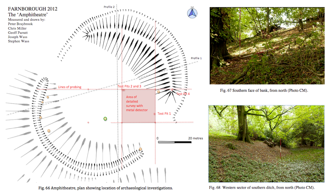
Discussion
Yentsch and Kratzer (1994: 181) suggest that, ‘the key steps towards understanding the spatial relationships utilized within a garden’s design are (1) establishing its boundaries, (2) finding its major axis and (3) locating other passageways through it’. This analysis works well for formal gardens, but in the context of planning at Farnborough we see Miller and Holbech making early, if not pioneering, use of the borrowed landscape. This process was aided by the invention of the sunken fence or ha-ha, generally attributed to the garden designer Charles Bridgeman working in the early decades of the eighteenth century ( Fleming and Gore 1979: 91). By adopting the surrounding countryside and, with the agreement of neighbouring landowners, carrying out additional planting of specimen trees they were able to create a garden that visually had no boundaries.
In terms of the park’s major axes it is evident that spatial arrangements including the location of water features were strongly influenced by the location and orientation of the hall (Fig. 70). The main entry to the hall is from the north-east (Fig. 2) where there is a limited prospect down the drive towards the village. There is no view at all to the south-east as this side was occupied by the hall’s service block. However, the views to the north-west and south-west were impressive in their ambition and effect.
Fig. 69 From lawn on north-west side of hall with amphitheatre outline.
It is difficult to capture the original view to the north-west because of the early nineteenth-century planting which turned Stanborough Hill into an arboretum. Much admired as the view is today, with mature trees mirrored in the pool’s surface, it surely cannot compare with the extraordinary effect the sculptural form of the amphitheatre would have had viewed across the water (Fig. 69). The slopes of Stanborough Hill were grassed over as was the central terrace of the amphitheatre whilst planting on the banks in 1772 was labeled as shrubbery.
Examination of surviving tree stumps shows that the top of the inner scarp of the lower ditch was lined with yews, but the overall aspect would have remained a very open one. As the spectator walked towards the edge of the ha-ha another extraordinary effect would have been revealed. To the west the full extent of the Oval Pond appeared jutting out towards the open fields in a way somewhat reminiscent of the modern ‘infinity pool’.
The outlook to the south-west passed over neatly cropped lawn to pasture, with the obligatory ha-ha separating the two, then along the entire length of the Canal before the line was picked by an avenue of oaks which ran for over half a mile (900 metres). The view today is broadly similar although the trees in the avenue have been replanted and the canal has lost some of its regularity. Again the effect is a clever one as the retaining dam remains largely invisible from the hall.
Fig. 70 Water, walks and vistas.
The existence of other view points can be assumed, either from the presence of buildings incorporating seating, or from other striking features in the landscape (Fig. 70). In nearly all cases water forms a significant part of the prospect. With the view from the game larder across the old Jacobean park and stew ponds to the church (Fig. 71) one could reflect on the landscape’s historic dimension whilst looking out from the top of the Cascade and the walk that approaches it the visitor could enjoy the naturalistic curve of the River (Fig. 51).
Fig. 71 From the Game Larder across Island Pool to church (Photo CM ).
The third component to this analysis of aspects of the park’s layout is the way in which passageways were effected through the landscape linking together the various elements. At Farnborough, as was the case in many early eighteenth-century gardens, hard paving seems to have been the exception rather than the rule.
Fig. 72 Chiswick, The Pond and Temple, c.1729 Pieter Andreas Rysbrack
As the painting of the amphitheatre at Claremont ( Fig. 65) and Rysbrack’s images of the gardens at Chiswick show, visitors were expected to explore the amphitheatres, enjoy the pools and admire the statues, by walking on the grass (Fig. 72). Farnborough has some designated routes as in the terrace walk and the yew walk down to the Cascade. Footbridges shown on the estate map also indicate walkways as does the presence of the broad flat tops to the dams. It is the presence of water that ties all this together, either in the walks conducted around the perimeters of the various ponds, or more ambitiously out along the line of the Serpentine River or down the brook that spills out across Stanborough Meadow (Fig. 70).
In summary the arrangement of the eighteenth-century park puts the hall and its occupants firmly at the centre of the composition, however, the strongest feature of its design is the virtuoso way in which large bodies of water are manipulated, reaching out into the landscape and creating special effects. The way in which water was used is notable both for originality of vision and sophisticated engineering. What is, however, particularly important is the way in which those water resources, already partially subsumed in the seventeenth century, are now entirely taken over and put to the service of the estate and its aesthetic pursuits. A landscape of pleasure has virtually monopolized the local supply of water.
Studies of period gardens have mainly taken an art-historical approach and our understanding of the technology employed in these landscapes remains limited (Roberts 2001: 12). In order to examine the construction of the eighteenth-century water features we will make use of contemporary manuals and the limited number of archaeological investigations on related structures.
Ponds and Dams
The garden designer and engineer Stephen Switzer (1734:128) felt it was easy: ‘With us… every ploughman and shepherd is able to make good reservoirs or ponds for holding of water’ and gave clear directions as to proportions: ‘three foot horizontal to one foot perpendicular’ and materials: ‘large spits of clay together just as they are dug out of the pit, only picking out the large stones, or any veins of sand you can find therein… then you are to throw some slaked lime over it’ (Switzer 1734:131). Roger North (1714: 5), ‘a person of honour’, writing two decades earlier gave similar advice as to materials and in particular the importance of, ‘good ramming, from a foot or so below the surface of the ground to such height as you propose the water shall stand’. His sizing for a middling pond indicates that for a dam 14 foot high at the centre one must, ’make your bank at the foot at least 50 foot wide, straightening by equal degrees on either side bring it up to 16 at the top’. North (1714: 15) was also very specific about the demands made on labour, ‘take the assistance of your neighbours and provide yourself with six tumbrels, four good horses and two stout labourers, besides a driver to each pair of tumbrels. I call them pairs because they work alternatively with the same horses so that one is filling, while the other is moving and your labourers as well as horses are always at work’. North (1714: 17) later recommends upping the labour force to twelve which should be adequate so that by, ‘observing these directions you may make two ponds in one month and not expend in money above 80 pounds although you pay for every hours work of man and horse’.
It is interesting to compare this forecast with other work that has been done on sites such as the experimental earthwork on Overton Down where labourers, using basic technology on hard chalk, could shift around 0.15 cubic metres per person per hour (Jewell 1963: 51). More material than this could be dug, but that demanded two other labourers moving and piling the spoil. A more recent set of figures comes from advice issued by the University of Sterling Institute of Aquaculture (2012) who, in giving guidance in reservoir construction for the tropics, suggest that for digging and moving earth by hand one cubic metre a day is reasonable whilst those spreading and compacting could handle two cubic metres. We can appreciate the scale of the work at Farnborough if we consider the dam of the Oval Pond. This amounts to around 10, 500 cubic metres of earth and would give North’s twelve stout labourers over 875 cubic metres each to shift, around three years’ work. If they wanted to complete the job in a summer season between planting and harvest, say 100 days, they would need to employ roughly 100 workers a day. Given that the entire male population of Farnborough in 1821 was 179 (Warwick CRO DR299/16) it is easy to see why North’s advice to call on neighbours for assistance was so apposite. Not all members of the gentry would take on such a project on a ‘do-it-yourself’ basis and it is possible that a professional engineer was employed at Farnborough such as John Grundy of Spalding (1719 to 1783) whose experience came from work on drainage and flood defence in East Anglia.
Fig. 73 Eighteenth-century dams, comparative profiles.
He was employed at Grimsthorpe Hall, Lincolnshire from 1745 to create the Great Water, a project for which his notebooks survive (Roberts 2001). Grundy’s work was generally considered to be of high quality and more technically accomplished than that of his competitors
(Roberts 2001: 18) and his cross valley dam at Grimsthorpe, whilst a little higher, is considerably wider than those at Farnborough (Fig. 73). Even so he was compelled to return in 1758 and 1774 to make repairs. His use of additional timber piling and a further clay lining (Roberts 2001: 24) recalls the situation at Noke, Herefordshire where the excavation of an early eighteenth-century dam revealed wooden stakes set in clay (Currie and Rushton 2001: 230). The dams at Farnborough are largely grassed over and there have been no opportunities to examine any internal structure.
Drains
Contemporary writers stressed the importance of a dependable supply of water and enormous pains were taken to ensure this, including the provision of subsidiary reservoirs around springs and on occasions pumps operated by animals or waterwheels (Roberts 2001: 22). It seems that at Farnborough the existing springs and streams were adequate for the task and, together with the drainage of the surrounding meadows, provided sufficient water. The complex pattern of drainage around the former manor site has already been noted (pages 20 to 21). Recent excavations have shown that prior to the nineteenth century a large quantity of ironstone quarrying debris was dumped in the moat to partially fill it and no doubt improve drainage (Wass 2012a). Brick lined culverts have been recorded emptying into the Island Pool and running below the dam of the Oval Pond. In addition a curious set of broad shallow drainage ditches have been noted, following the field boundaries on the estate map and running straight down the hill below the terrace (Fig. 74).
Fig. 74 Ditch between The Warren and Dairy Close, from south-west (Photo VW).
Fig. 75 Staunch lock on River Lark at Fornham c. 1710, from south-east (Photo Bob Jones).
Fig. 75 Staunch lock on River Lark at Fornham c. 1710, from south-east (Photo Bob Jones).
Sluices
The most refined technical accomplishments are the sluices along the Serpentine River. Currie (1990: 35) notes that, ‘in all the treatises examined there is very little recorded about sluices’, perhaps because they were regarded as the province of specialized craftsmen. Usually the term sluice describes an arrangement for draining a pond through a pipe or culvert, often of wood, that passed below or round the dam. Control was usually by wooden paddle or bung (Roberts 2001:22). The sluices at Farnborough are much more reminiscent of staunch or flash locks, features associated with early canal and river navigation. These operated on the principle of a pair of mitre gates which retained the water at a suitable level for navigation. Approaching boats were held back while a small sluice was opened to drop the water level a little and then the gates were opened to allow the boats to slip through. Such locks (Fig. 75) were used from the earliest times and were still reasonably common in England in the first half of the eighteenth century until they were replaced with the more familiar pound locks (Hadfield 1968: 19). Was the Serpentine River navigable? A similar visual effect could have been achieved by more conventional earth dams, so the sluices must have been installed with some functionality in mind, however, there is no evidence that the stream beyond was ever adapted for boats.
Fig. 76 The Serpentine River, longitudinal section.
Projecting the water levels back from the presumed height of the gates gives an indication of the relative water heights and demonstrates that the cascade below sluice 4 would have been visible even when sluice 5 was closed (Fig. 76). Could Holbech have employed contractors whose experience on early canals led them to build the only way they knew, or were the sluices designed simply to demonstrate the technology? Would the arrangement have helped if there was ever a need to drain the water-course in a hurry? The whole question of the use of sluices on the Serpentine River remains open, but the conjecture is that they had some purpose other than the ornamental.
Finance
North promised that one could deliver a lake of between three and four acres for eighty pounds. Given that most of the raw materials would have been available on the estate the main cost would have been for labour at as little as a shilling a day (Porter 1991: vii). If a specialist supervisor had been appointed on the same basis that Grundy worked he would have charged one shilling for each pound of the project’s cost (5%). Money would need to be set aside for both carpenters and stone masons to work on sluices and cascades. These higher paid artisans may also have been available as employees of the estate, but would have commanded higher wages than the labourers, as much as five shillings a day. Taking all this into account we might expect the work on the Oval Pond to have cost in the region of £600. A further attempt at costing can be made on the basis of sums paid out during the construction of the Wiltshire and Berkshire Canal in 1797, where 31/2 d per cubic metre was paid for digging and 11/2 d for carting (Lawton 2006: 300). On this basis the earthworks alone could have cost around £300. Similar calculations for the other water features suggest an overall bill for Farnborough between £2,500 and £3,000. This compares with an estimate for £1,250 2s 1d from Grundy for a major expansion to the Great Water at Grimthorpe (Roberts 2001: 28)
There is one near contemporary account of the workers’ efforts, penned by a local curate, Richard Jago, who was a friend of Miller’s.
Hear they her Master's Call? in sturdy Troops,
The Jocund Labourers hie, and, at his Nod,
A thousand Hands or smooth the slanting Hill,
Or scoop new Channels for the gath'ring Flood,
And, in his Pleasures, find a solid Joy. (Jago 1767)
The Jocund Labourers hie, and, at his Nod,
A thousand Hands or smooth the slanting Hill,
Or scoop new Channels for the gath'ring Flood,
And, in his Pleasures, find a solid Joy. (Jago 1767)
Alas we must in all probability ascribe the work force of five hundred and their merry countenances to poetic licence and there is no mention of their wages.
Williamson (1999: 252) suggests that, ‘Once we have reconstructed the layout and appearance of early landscapes we must… try to recreate the ways in which they would have been perceived and experienced from various spatial standpoints by the different social actors moving within (or excluded from) them’. This is not the place to enumerate every conceivable way in which people and water could have interacted but rather to focus on those aspects which have left significant remnants in the landscape. No doubt occupants of the hall made copious use of water for drinking, cooking and washing, however, as the service block which contained a dairy, brewhouse and kitchen was demolished in the 1930s there are few traces. It is worth noting the presence of an icehouse to the west of the hall (figs. 42 and 77) which made use of the seasonal freezing of pools (Buxbaum 2008). Workers would have chopped out blocks of ice in the winter to provide ice for the kitchens in the summer.
In order to populate the eighteenth-century landscape we will need to turn to other contemporary documents including paintings. Being aware of the dangers of projection and the assumptions one makes about the ‘familiarity of the past’ (Tarlow 2004) , one can attempt to gain insights by appealing to common human impulses which are shared today by workers in the park and visitors to it. The ponds and waterways were a place of work to those who laboured on the estate and of leisure for the Holbechs and their guests. It is interesting that it remains the case that most accounts still present an upstairs rather than a downstairs perspective of the country estate.
Fig. 77 Icehouse entrance, from south-west. Fig. 78 Scrubbing algae off the Cascade (Photo CM).
Work
In working with water, the local labourers would have had a role both in construction and maintenance. Tasks, which are shared by the modern work force, included periodic dredging of pools as they silted up, repairs to banks damaged by livestock and unblocking and repairing sluices. Observations on the cascade have shown that in summer the stonework becomes covered with unsightly brown algae which needs to be removed by hard scrubbing every couple of weeks (Fig. 78).
It seems likely that the pools were managed for fish into the eighteenth century, a complex business involving transferring stocks from pool to pool, feeding, the periodic emptying of pools for cleaning and, of course, harvesting and preparing the fish for the table (North 1714: Chapters XI to XVIII). Even with every modern aid working around water is a cold and dirty business, how much more so in the eighteenth century. We have no documentation relating to these processes at Farnborough, as is the case generally, the voice of the eighteenth-century labourer remains silent. The fact that it is easier to say many more interesting things about the recreational uses of water is perhaps a simple reflection of the cultural hegemony enjoyed by the social elite.
Leisure
North (1714:73) is particularly strong on the recreational benefits that accrue to a gentleman’s family as a result of embracing water, ‘Young people love angling extremely; then there is a boat, which gives pleasure enough in summer, frequent fishing with nets, the very making of nets, seeing the waters, much discourse of them, and the fish, especially upon your great sweeps, and the strange surprises that will happen in numbers and bigness, with many other incident entertainments, are the result of waters, and direct the minds of a numerous family to terminate in something not inconvenient, and it maybe divert them from worse’. The view by Rysbrack (Fig. 72) also neatly encapsulates the recreational opportunities afforded by water. We see a couple promenading by the water, gentlemen angling from a boat and a flight of ducks available for wild-fowling, a pattern repeated in many similar genre paintings from the eighteenth century.
Walking.
Contemporary documents such as Miller’s own diary entry for July 21st. 1750 emphasise the importance of walking within the context of living well, ‘Lord North and Miss Legge breakfasted at castle. Went with Lord Cobham etc. to Mr. Holbech and to Dassett. Mr. Holbech dined with us. Camera Obscura. Walked with Lord Cobham, Holbech and Miss Banks round Wood Close, fountain etc. Supped at castle with Lord North etc. and Holbech. Fine evening. Music. Lord Cobham’s venison’ (Hawkes 2005: 150). The presence of water would enhance the experience of walking to all the senses, ‘when the shadows grow faint as they lengthen: when a little rustling of birds in the spray, the leaping of the fish, and the fragrancy of the woodbine, denote the approach of evening’(Whately 1770: 86). These experiences were not only confined to the owner and friends. There were opportunities for members of the public, albeit of the better sort, to make visits, often on carefully designed designated walks around an estate (Symes and Haynes 2010: 22). Although we have no indication that this happened as a matter of course at Farnborough, it is clear that other members of the gentry were made welcome and given the chance to tour the gardens (Meir 2006: 87).
Boating.
We have no evidence of boating in the eighteenth century at Farnborough. Although a boathouse is shown on the 1885 OS map on Sourland Pond (Fig. 79) it does not appear on the 1772 map, however, it is hard to believe that boats were not present here. Miller had designed a boathouse (Fig. 80) for Enville in Staffordshire (Meir 2006: 151) and would have been well acquainted with the extensive use of boats on the lakes at Stowe, Buckinghamshire (Felus 2006: 26). Lady Newdigate who visited Farnborough in 1747 might have expected to see boats. She wrote in her Journal of another location, 'in a small boat we rowed to the Severn and then in a very pretty vessel built by Mr. Cambridge, the Cabin lined with Japan and Indian paintings we sailed for several hours, the view all the way very pleasant' (WCRO CR1841/7: 53).
Fig. 79 Boathouse, Sourland Pond, OS Map 1885.
Sourland Pond seems an ideal venue for boating as its pronounced curve around Stanborough Hill would have given a feel for a great journey in a small space. Felus (2006: 30) also mentions the naumachia or mock naval battle, inspired by classical precedents and indulged in by the Byrons at Newstead, Nottinghamshire and the Dashwoods at West Wycombe, Buckinghamshire. Is it too fanciful to note that the Oval Pond shares very closely in the proportions and size of the floodable area of the Colosseum in Rome? This is not to say that William Holbech filled it with battling galleys but perhaps there was an echo of this famous monument somewhere in the back of his mind.
Angling.
The layout of the pools at Farnborough was well suited to the maintenance of fish stocks on a large scale and whilst fish could be caught by netting they would also offer the opportunity for the pastime of angling. Anglers appear in many eighteenth-century prints and paintings and a large number of books on the subject were published during the period (Rodd 1846: 84) attesting to its popularity as a sport for gentlemen and indeed ladies. Fishing pavilions known from Enville, Staffordshire ( Fig. 80) and Kedleston, Derbyshire reinforce this picture, but again, save for the existence of the ponds, we have no direct evidence for angling at Farnborough.
Fig. 80 Boathouse/angling pavilion and lake, Enville, Staffordshire by E. Barber 1800
Wild-Fowling
Another sport which gained popularity through the eighteenth century as firearms became more reliable and readily available was the hunting of wild fowl. It has been suggested that the island at the eastern end of the Island Pool with its narrow looping channel could have served as a duck decoy. This is unlikely as the normal form was to have lengths of water of diminishing width, opening off from a central pool (Heaton 2001). These were netted over and the birds lured or driven in to them (Fig. 81). It is more reasonable to assume that the island was created as a refuge for wild fowl, where they could roost and nest in safety from predators. The presence of the game Larder shows how important hunting was on the estate (Fig. 92).
Fig. 81 Operating a duck decoy (Payne-Gallwey 1886: 15).
Swimming
Of all the activities noted so far, swimming seems to be the one least likely to leave archaeological traces. It is hard to see today’s muddy, overgrown stretches of water, choked with fallen trees, as anything but a health hazard (Fig. 82) , however, when newly built with firm banks and pebble bottoms one could envisage features such as the Oval Pond or the Canal being appropriate venues for swimming. One possible indication that we have of interest in this activity is a document preserved in a Holbech family scrapbook from the mid-eighteenth century (WCRO CR656/36). Amongst newspaper cuttings for a variety of sports ranging from prize-fighting to horse-racing is an engraved handbill publicizing the opening of Peerless Pool in London in 1743. For a guinea a year gentlemen could enjoy all the benefits of swimming in a safe environment with ‘waiters’ on hand to teach swimming to novices. The accompanying illustration not only shows swimmers in action but also a couple of adjacent ponds for angling and two large prospect mounds joined by a terrace ‘planted with limes’. If nothing else it is an indication of the kinds of cultural influences that could have been operating on Holbech during the crucial decade in the park’s transformation.
Fig. 82 the north side of the Island Pool
Experiencing the Cascade
Our final imaginative leap is to attempt to draw on even less tangible elements of the past and recreate one potential way in which a water based construct could have been experienced in the eighteenth century. This idea was developed in an earlier piece (Wass 2011c) where we noted the lack of visibility on the approach to the Cascade implying an element of discovery and anticipation for the visitor. The structure of the Cascade (Fig. 50) seems to draw one into experiencing it in very particular ways which include walking across the flat slabs at the base of the flow (Fig. 83) and striking out along a spiral path to attain the summit with its view along the River (Fig 51).
Fig. 83 Flat slabs at base of Cascade, from north.
This led to the creation of a slightly tongue-in-cheek visitor’s guide (Fig. 84). Other sites where, ‘garden features… were designed to trick, tease or thrill the visitor’ have been listed (Wass 2011c: 16), including the hidden fountains at Wilton House which were ‘… like a plash’d Fence, whereby sometimes faire ladies cannot fence the crossing, flashing and dashing their smooth soft and tender thighs and knees by a sudden inclosing them in it’ (Quoted in Strong 1997: 130). This kind of titillation may have been better suited to earlier centuries or warmer climes (Thacker 1970: 20), but we must allow for the possibility of an eighteenth-century sense of fun.
Fig. 84 The Lovers Plash’d’ an eighteenth-century comedy of manners.
Discussion
One is very aware of the contrasts between the two different ways in which people experience water around the park. On the one hand the labourers responsible for its upkeep were likely to be task oriented and motivated by the simple mechanics of providing for themselves and their families. Their options were limited and their focus on getting the job done in the best way they knew. On the other hand there are the gentry who had so many more options to choose from. It was even possible to write poetry; in 1786 M. Dawes published an octavo volume entitled ‘Holbeach Fish-pond, a Poem’ (Rodd 1846: 84), unfortunately we have not been able to discover a copy.
It is important not to fall into a narrative which features, ‘contests between hapless peasants and villainous landlords’ (Tarlow 2007:10) and accept Williamson’s (1999: 253) point that, ‘eighteenth-century England was a complex society and not one composed of two confronting groups’, however, it is difficult to think about a feature like the Oval Pond without considering dichotomies. Walking out towards Meir’s (2006: 91) ‘bastion’ at the far end of the pond one would be confronted with an astonishing prospect. To the right the large elevated expanse of water, perhaps with pleasure craft upon it, to the left and decidedly below, a bleak landscape of labour consisting largely of the still open fields belonging to adjacent villages (Linnell 1772).
Fig. 85 North from Ionic temple, The River and Canal in mid-ground, Oval Pond behind wall and trees to right.
A structure such as the Oval Pond cannot be seen as anything other than domineering, it pushes out across flat fields and imposes leisure upon labour (Fig. 85). We do not know how this construction was viewed at the time, indeed all the labourers may have continued to be ‘jocund’, relieved to have a steady wage from employment on the estate. Even so there is no sense in which this was a community enterprise, rather it represents a transformation effected by two gentlemen with their own particular and peculiar interests. One cannot believe that such a transformation was met with equanimity by the rest of the population.
This narrative could be abandoned at the point where water usage is at its most extravagant but to do so would be like leaving off a biography without pondering the subject’s final years and possible extinction. By the early-nineteenth century the estate was in something of a decline. In 1810 a curious poem was posted anonymously to Charles Holbech, brother of the William who had inherited in 1771. The poem is entitled ‘The Lamentation of the Botanic Gardens at Farnborough’ (WCRO CR656/36) and appears to be a plea that the gardens be put in order so that, ‘no more shall urtica (nettle) eclipse the rose’, and ‘ no supple juncus (rush) with incessant bow, court the green mantle of the stagnant lake’. In 1812 another William took on the estate and by 1815 a further major programme of work was underway supervised by the architect Henry Hakewill (English Heritage 2011). The estate was put on a more productive footing and new buildings included cowsheds (Wass 2012d) and a large octagonal walled garden with a stone lined pool at its centre (Fig. 86). A graveled path led from the garden, through a short tunnel, to another path across the Paddock and up to the kitchens. The moat was further filled with brick rubble and, post-1850, large clay land drains were inserted (Wass 2012a), demonstrating the continuing importance of effective drainage (Fig 87).
Fig.
86 Pool in walled garden, from north.
Fig. 87 COA 12
Filling/drainage of moat, from east.
Fig. 88 Excavations of summerhouse, poles mark position of corner posts, from north-west.
In the early-nineteenth century a summerhouse (Fig. 88) was built on a terrace cut into the mound at the back of the Cascade and a wooden footbridge on brick piers (Fig. 89) thrown across the inlet to the River (Wass 2011b). This post-dates the building of a new road to Avon Dassett by Charles Holbech. The Oval Pond was drained between 1820 and 1880 and typically for the period was converted in a fox covert (Watkins, N. 2007).
Fig. 89 Brick pier to footbridge, from west.
The kitchen garden was abandoned shortly after the First World War and was for a while worked as an independent market garden until it closed in the 1950s. The hall had had its own water supply from a borehole on the top of the hill to the south-east sunk in the first half of the twentieth century. The water was pumped up by a windmill and stored in a brick cistern before being piped to the hall. In 1957 mains water came to Farnborough and shortly afterwards a sewage works was built on the edge of the former Oval Pond (Fig. 90).
Fig. 90 Sewage works, from south-west.
The Serpentine River was drained after the Second World War and in 1960 the National Trust took over guardianship of that portion of the park which had not been sold in 1948. Today the residents of the hall stock the pool with wild-fowl over winter for shooting and operate a small rowing boat on the River for retrieving downed birds. Sourland Pond is let out to the Banbury and District Angling Association and in the summer people come and picnic on the grass next to it. The grounds close to the hall are managed by a gardener and a part time assistant, whilst the remaining agricultural land is let out to a tenant farmer. The decades since the Second World War have not been kind to the monuments of Farnborough Park. Whilst those buildings with architectural pretensions have been well maintained, lesser buildings, including a small apple store and a bier shed and several agricultural buildings, have fallen into disrepair and in some cases, total collapse. Those structures which helped the water to do interesting things are in a particularly parlous state and again have either partially collapsed or are about to…
Fig. 91 National Trust staff prepare for excavation, Church Oakal A site.
Following our chronological survey we will return to our central concern, the understanding of those elements within the eighteenth-century park linked to water and how they reflect ‘patterns of power and dominance’. We have touched on the answers to most of the questions posed in chapter 5 but two remain outstanding. The first of these is the question as to how it was all planned. The problems of assessing the contributions of a ‘gentleman architect’ have already been examined. Faced with these difficulties researchers Meir and Hawkes adopted the procedure whereby evidence of a visit to a site was fused with perceived stylistic traits to establish a corpus of work. It is no great criticism to point out the extremely speculative nature of this approach. Meir (2006: 217) especially, argues for the recognition of Miller’s fingerprints on a range of projects and suggests that, ‘The inventive use of water, and an ability to find successful technical solution to intractable drainage problems together form a major component of Miller’s “stylistic signature”’. She further cites an informal layout for lakes and a fondness for long thin waterways punctuated with sluices or cascades which occasionally are doubled up to run along side other existing water courses. The phrase used by Miller’s great-grandson to describe his involvement was ‘assisted by the advice of’ (Miller 1900: 61).
Fig. 92 The classical Game Larder, from north.
It is easy to see from Miller’s diaries how this assistance was rendered. Occasionally he would sit down and draw detailed plans (Hawkes 2005:161), but more often it was a walk in the park with Miller pointing out solutions to problems or opportunities for development, followed up perhaps with a letter ( Hawkes 2005: 164). This process of design through conversation throws open the possibility of dialogue between architect and patron and given the preponderance of classical detailing at Farnborough there is a strong case for William Holbech’s being the dominant partner. Miller did not have a good track record for classical buildings, indeed John Cornforth writing in Country Life dismissed Miller as someone who, ‘demonstrated no significant ability in working in the classical style at this date’ (Cornforth 1996 cited by Hawkes 2005). Apart from the five possible structures at Farnborough ( Figs. 34, 38, 39 and 92) Miller built only a handful of classical garden buildings during a thirty year career (Hawkes 2005: 391 to 408). Virtually all his other work was in the gothic style. The absence of gothic buildings at Farnborough indicates this strong lead from Holbech. If Holbech was giving instructions regarding the provision of classical buildings it is fair to assume that he may have made similar requests concerning unusual features like the amphitheatre and the Oval Pond. If we examine other water features attributed to Miller, the only thing at Farnborough typical of his work is the Serpentine River. In other respects both the scale and configuration of the works at Farnborough bear little resemblance to other projects (Fig. 93). The likelihood is that Miller was responding with advice and perhaps some technical expertise under the direction of a landowner who was trying to create a peculiarly classical landscape, which was not only reflected in the buildings, but also in the way in which earth and water were engineered. The source of inspiration was the vision, passion, perhaps even obsession, of the landowner.
Fig. 93 Water features attributed to Miller, comparative plans, squares 1 kilometre.
The final question and perhaps the most challenging is what was the purpose of this large-scale landscape transformation? Individual landowners did not have to express or explain their reasons, even to themselves, so explanations can only ever be provisional, however, by looking at the wider context, we can venture some suggestions. There are four key concepts: the social politics of separation and unification, the demands of good taste, the power of imagination and the economics of the country estate.
Social Politics of Separation and Unification
Many commentators have stressed the ways in which eighteenth-century garden design was used in terms of legitimation, ‘a tool with which elites attempted to maintain power and authority over marginalized groups’ (Williamson 1999: 37). The estate is a means of control and domination by imposing a particular world view on a locality through landscaping whilst simultaneously restricting options for the rest of the community in terms of movement, access and labour. This is a powerful theme within Farnborough’s story. From the closure of the route to the holy well to the dominating effect on the landscape of the Oval Pond this seems to be about under-scoring inequalities of power. Williamson (1999: 37) did move away from this position taking the view that, ‘most acts of aesthetic landscaping…were primarily directed not towards "the poor" but to rival groups within the propertied’. In making this point he emphasized the closed nature of many parks of the period, however, Farnborough is a very open landscape, much of what is on offer is widely visible so perhaps Johnson’s (1996:145) more nuanced view that, ‘around the great house the gardens were planned as a mediation between the elite and the ordinary as well between Nature and Culture’ is more productive, reflecting interactions, both positive and negative, within the full spectrum of society. This is emphasized in Miller’s diaries (Hawkes 2005) where it is clear that he enters into relationships, within the context of the park, with all manner of men and women from lady to labourer. We can therefore take a more positive view of the park as a meeting place where certain boundaries can be crossed. It is equally obvious that within Miller’s social group, of which we must count William Holbech a member, as well as companionship there was also competition based on the notion of good taste.
The Demands of Good Taste
Opportunities for self expression were characterised by the fact that,
‘by the eighteenth century a patron could choose between one of a number of different architectural and landscape styles’ (Johnson 1996:152). If this was coupled with, ‘untrammeled or only very partially limited power over the exploitation and physical appearance of an extensive tract of countryside’ (Williamson 2007: 4) then the potential for making statements about one’s own aesthetic judgment was enormous. Holbech’s ten years in Italy, at a time when the Grand Tour was de rigueur, must have given him authority as an arbiter of classical taste amongst his social circle (Fig. 94). One can see his work at Farnborough as an exemplar as to what could be done but also perhaps an object lesson in the way in which tasteful could spill over into mannered if enthusiasm is given too free a rein. It was possible to be too imaginative and end up with that most despised quality, ‘the merely whimsical’ (Thoreau 1854: 19).
Fig. 94 The social web, Midland landowners
( from Symes and Hynes 2012: 12, additions in red).
( from Symes and Hynes 2012: 12, additions in red).
The Power of Imagination
In describing the park I have often found myself using the analogy, ‘it’s like an eighteenth-century theme park’. In developing a similar point about the gardens at Stourhead Harwood (2002: 50) writes of, ‘the recognition that what they were seeing were theatrically contrived settings, the juxtaposition of which suggested an organized collection of opportunities for imaginative play’. At the risk of falling into the trap of developing the ‘existential and isolated presentism of phenomenological perspectives’ (Hicks 2003: 321) one has to say that in experiencing the park today one senses a history of enjoyment. There has been a description, with some license, of the goings-on around the Cascade (Fig. 84) and there is a feeling that the disposition of the terrace buildings was to tantalize in the sense of, ‘I wonder what’s around the next corner’. From the erection of ‘toy’ forts (Felus 2006: 30) to the placement of hermit’s caves one was expected to use one’s imagination as a playful participant in the landscape (Symes and Haynes 2010: 33). Holbech’s scrapbook of newspaper cuttings (WCRO CR656/36) reveal him to be something of a sportsman, was he a joker too?
Economics of the country estate.
The concept of improvement is often linked to ideas of economic advancement, but Tarlow sees it as also demonstrating,’ the ownership of rational knowledge and taste, a general orientation towards the future and a selective rewriting of the historical and classical past’ (Tarlow 2007: 67). This combination of the productive with the decorative was praised by Switzer, ‘a whole estate will appear as one great garden, and the utile woven harmoniously with the dulci… I affirm that an even walk carried through a cornfield or pasture… is as pleasing as the most finished parterre’ (Switzer 1742: 8). Farnborough represents an ideal example of such a ferme ornée: the ponds are a source of fish as well as a venue for boating and the view towards the River takes in the pasture known as the Dairy Ground. A striking feature of the park is the way in which unproductive land is turned to recreational ends. Sourland Pond speaks for itself and it is noticeable how the Terrace occupies the steep, wind-swept brow of the hill leaving the summit and slopes for grazing. Ponds and pounds march along together.
The End.
The park’s purpose was intimately linked to the social fabric of the time and served many of same purposes as today’s gardens: supplementing the family diet, relaxation, exercise, entertaining and of course one-upmanship but, as with any archaeological site that exhibits a number of unique features, Farnborough Park remains both baffling and revealing. There are many unresolved questions about how the landscape was manipulated by Holbech and Miller but what is clear is that we have a classic case of the exploitation of a particular resource, water, in a way which demonstrates the acquisitive drive of the land-owning elite over several centuries. There is no access to St. Botolph’s Well or the adjacent pools. The River and Canal may be viewed from the terrace after paying an entry fee but the Serpentine River is becoming quietly lost amongst commercially farmed land to the south. Only Sourland Pond exists as a community resource with fishermen lining its banks and families from Banbury coming out to feed the ducks. (Fig. 1).
Plus ça change, plus c'est la même chose (Karr 1849).
Aberg, F.A. (ed.) 1978. Medieval Moated Sites, York: Council for British Archaeology
Astill, G. G. 1993. A Medieval Industrial Complex and its Landscape: the metal working watermills and Workshops of Bordesley Abbey, York: Council for British Archaeology
Aston, M. 1985. Interpreting the Landscape, Landscape Archaeology in Local Studies, London: Batsford
Aston, M. (ed.) 1988. Mediaeval Fish, Fisheries and Fish-ponds in England, Oxford: British Archaeological Reports
Bailiff, I. K. 2007. Methodological Developments in the Luminescence Dating of Brick from English Late-Medieval and Post-Medieval Buildings, Archaeometry Volume 49, Issue 4, pages 827 to 851
Blair, J. 1994. Anglo-Saxon Oxfordshire, Stroud: Alan Sutton Publishing
Buxbaum, T. 2008. Icehouses, Oxford: Shire Publications
Cannon, J. 1987. Aristocratic Century, The peerage of eighteenth-century England, Cambridge: Cambridge University Press
Chanson, M. 2001. Historical Development of Stepped Cascades for the Dissipation of Hydraulic Energy, Transactions of the Newcomen Society, Volume 72, pages 295 to 318
Cherry. R. 2011. Notes of conversation with local retired builder, 15.3.11
Chisholm, M. 1979, Rural Settlement and Land Use, London: Hutchinson
Corfield, P. J. 1996. The Rivals: Landed and Other Gentlemen in Harte, N. B. and Quinault. R. (eds.), Land and Society in Britain, 1700-1914, Manchester: Manchester University Press
Currie, C. 1990. Fishponds as Garden Features, c. 1550-1750, Garden History, Volume 18, number 1, pages 22 to 46
Currie, C. 2003. Archaeological excavations at Upper Lodge, Bushy Park, London Borough of Richmond, 1997-99, Post-medieval Archaeology, Volume 37, Number 1, pages 3 to 45
Currie, C. 2005. Handbook of Garden Archaeology, York: Council for British Archaeology
Currie, C. and Rushton, N. 2001. The Historical Development of the Court of Noke Estate, Pembridge, with an Archaeological Assessment of Canal-like Water Features, Transactions of the Woolhope Naturalists Field Club, Volume 50, Number 2, pages 224 to 250
Duignan, W. H. 1912. Warwickshire Place Names, Oxford: Oxford University Press
English Heritage 2011. Farnborough Hall, Banbury, England, Record Id: 1304 Register of Parks and Gardens of Special Historic Interest, http://www.parksandgardens.ac.uk/component/option,com_parksandgardens/task,site/id,1304/tab,history/Itemid,305/
accessed 12.9.2011
Felus, K. 2006. Boats and Boating in the Designed Landscape, 1720-1820, Garden History, Volume 34, number 1, pages 22 to 46
Gearey, B. R., Hall, A. R., Bunting, M. J., Lillie, M. C., Kenward, H. and Carrott, J. 2005. Recent palaeoenvironmental evidence for the processing of hemp (Cannabis sativa L.) in eastern England during the medieval period, Medieval Archaeology, Volume 49, pages 317 to 322
Gosden, C. and Marshall, Y. 1999. The Cultural Biography of Objects, World Archaeology, Volume 31, Number 2, Pages 169 to 178
Harrower, M. J. 2009. Is the hydraulic hypothesis dead yet? Irrigation and social change in ancient Yemen, World Archaeology, Volume 41, Issue 1 , pages 58 to 72
Harwood, E. 2002. Rhetoric, Authenticity, and Reception: The Eighteenth-Century Landscape Garden, the Modern Theme Park, and Their Audiences, in Young, T. and Riley, R. (eds.) Theme Park Landscapes: Antecedents and Variations, Washington: Dumbarton Oaks Colloquium on the History of Landscape Architecture, volume 20
Hawkes, W. (ed.) 2005 . The Diaries of Sanderson Miller of Radway, Stratford-upon-Avon: The Dugdale Society
Haworth, J. 1999. Farnborough Hall, London: National Trust
Heaton, A. 2001. Duck Decoys, Oxford: Shire Publications
Hicks, D. 2003. Archaeology Unfolding: Diversity and the Loss of Isolation, Oxford Journal of Archaeology, Volume 22, Issue 3, pages 315 to 329,
Hindle, S. 2003. Crime and Popular Protest, in Coward, B. (ed.) A Companion to Stuart Britain, Oxford: Blackwell
Ince, L. 2011. A History of the Holbeche Family of Warwickshire and the Holbech family of Farnborough, Studley: Brewin Books
Jago, R. 1767. Edge-Hill, or the Rural Prospect Delineated and Moralised, London
Jewell, P. A. (ed.) 1963. The experimental earthwork on Overton Down Wiltshire, London: British Association for the Advancement of Science
Joy, J. 2009. Reinvigorating object biography: reproducing the drama of object lives, World Archaeology, Volume 41, Issue 4, pages 540 to 546
Karr, A. J. 1849. Les Guêpes, Paris: January Edition
Lawton, B. 2006. Building the Wilts and Berks Canal, 1793–1810, Transactions of the Newcomen Society, Volume 76, Pages 291 to 313
Liddiard, R. 2005. Castles in Context, Macclesfield: Windgather Press
Linnell, E. 1772. Farnborough Estate Survey, Warwickshire County Records Office Ref. z 403 (u)
Meir, J. 1997. Sanderson Miller and the landscaping of Wroxton Abbey, Farnborough Hall and Honnington Hall, Garden History, Volume 25, number 1, pages 81 to 106
Meir, J. 2002. Development of a Natural Style in Designed Landscapes between 1730 and 1750: the English Midlands and the Work of Sanderson Miller and Lancelot Brown, Garden History, Volume 30 number 1, pages 24 to 48
Meir, J. 2006. Sanderson Miller and his Landscapes, Chichester: Phillimore
Miller, G. 1900. Rambles Around Edge Hill, London: Elliot Stock
Mowl, T. 2006. Preface to Meir, J. 2006. Sanderson Miller and his Landscapes, Chichester: Phillimore
Mowl, T. 2010. Gentleman Gardeners: the Men Who Created the English Landscape Garden, Stroud: The History Press
Mowl, T. and James, D. 2011. Historic Gardens of Warwickshire, Bristol: Redcliffe
Muir-Beddall, A, 2012. Current occupant of Farnborough Hall, notes of conversation 30.8.12
Nares, G. 1954. Farnborough Hall, Warwickshire, The Home of Mr. R.H.A. Holbech, Parts I and II, Country Life, 115 (11 February 1954), pages 354 to7; (18 February 1954), pages 430 to 433
North, R. 1714. Discourse of Fish and Fishponds, London: E. Curll
O’Keeffe, T. 2010. Review, Cambridge Archaeological Journal, Volume 20, number 1, pages 148 – 154
Pauls, E. P. 2006. The Place of Space: Architecture, landscape and Social Life, in Hall, M. and Simpson, S.W. (eds) Historical Archaeology, Oxford: Blackwell Publishing
Payne-Gallwey, Sir R. 1886. The Book of Duck Decoys, their Construction, management and History, London: John van Voorst
Pevsner, N. and Wedgwood, A. 1986. The Buildings of England Warwickshire, Harmondsworth: Penguin Books
Porter, R. 1991. English Society in the Eighteenth Century, London: Penguin Books
Radley, J. D. 2003. Warwickshire’s Jurassic geology: past, present and future, Mercian Geologist, Volume 15, number 4, pages 209 to 218
Roberts, B. K. 1987. The Making of the English Village, A Study in Historical Geography, Harlow: Longman Scientific and Technical
Roberts, J. 2001. 'Well Temper'd Clay': Constructing Water Features in the Landscape Park, Garden History, Volume 29, Number 1, pages 12 to 28
Salzman, L.F. (ed.) 1949. A History of the County of Warwick: Volume 5 Kington Hundred, London: University of London, Victoria County History, pages 84 to 88
Rodd, T. 1846. Catalogue of Books, Part II Jurisprudence and Political Economy. London: Compton and Ritchie
Sayer, D. 2009. Medieval waterways and hydraulic
economics: monasteries, towns and the East Anglian fen, World Archaeology Volume 41, Issue 1, pages 134 to 150
Schmidt, A. J. 2009. Review Journal of Social History, Volume 43, number 1, pages 242 to 243
Steane, J. M. 1984. The Archaeology of Medieval England and Wales, London: Croom Helm
Strong, R. 1998. The Renaissance Garden in England, London: Thames and Hudson
Switzer, S. 1734. A Universal System of Water and Water-works: Philosophical and Practical, London: Thomas Cox
Switzer, S. 1742. Iconographia Rustica, Second Edition, London
Symes, M. and Haynes, S. 2010. Enville, Hagley, the Leasowes, Three Great Eighteenth Century Gardens, Bristol: Redcliffe Press
Sulas, F., Madella, M. and French, C. 2009. State formation and water resources management in the Horn of Africa: the Aksumite Kingdom of the northern Ethiopian highlands, World Archaeology, Volume 41, Issue 1, pages 2 to 15
Tarlow, S. 1999. Capitalism and Critique, Antiquity, Volume 73, number 280, pages 467 to 470
Tarlow, S. 2007. The Archaeology of Improvement in Britain 1750 – 1850, Cambridge: Cambridge University Press
Tarlow, S. and West, S. (eds.) 2004. The Familiar Past? London: Routledge
Thacker, C. 1970. Fountains: Theory and Practice in the Seventeenth and Eighteenth Centuries, Occasional Paper – Garden History Society, Number 2
Thoreau, H. D. 1854. Walden; or, Life in the Woods Boston: Ticknor and Fields
Trigger, B. G. 2006. A History of Archaeological Thought, Cambridge: Cambridge University Press
University of Sterling 2012 Pond Construction – Estimating the Cost
http://www.researchintouse.com/resources/riu11-factsheet-2-cost-estimation.pdf accessed 27.8.12
Walter, J. and Wrightson, K. 1976. Dearth and the Social Order in Early Modern England, Past and Present , Volume 71
Warwickshire County Record Office, The Lamentation of the Botanic Gardens at Farnborough, CR656/36
Warwickshire County Record Office, 1821 household census of Farnborough, Warwickshire, DR 299/16.
Warwickshire County Record Office, Lady Newdigate’s Travel Diary. CR1841/7
Warwickshire County Record Office, Notice of the Opening of the Bathing waters of the Peerless Pool, 1743 CR656/36
Wass, S. 2011a. The Farnborough Park Project,
http://www.polyolbion.org.uk/Farnborough/Project.html
Wass, S. 2011b. Report on Excavations at the Summerhouse site, Farnborough, Unpublished Report for the National Trust,
http://www.polyolbion.org.uk/Farnborough/Summerhouse%20Dig/Report.html
Wass, S. 2011c With reference to one particular place (a building or a landscape) describe how the ethic of improvement shaped the physical world during the eighteenth to twentieth centuries. Assignment for University of Leicester Module: The Archaeology of the Modern World, Submitted September 19th. 2011,
http://www.polyolbion.org.uk/Farnborough/Ethic/Improvement.html
Wass, S. 2012a. Interim Note on Excavations at Church Oakal A site, Farnborough, Unpublished Evaluation Report for the National Trust
Wass, S. 2012b. Interim Note on Excavations at Church Oakal B site, Farnborough, Unpublished Evaluation Report for the National Trust
Wass, S. 2012c. Interim Note on Investigations at Site 3: The ‘Amphitheatre’, Unpublished Evaluation Report for the National Trust
http://www.polyolbion.org.uk/Farnborough/Amphitheatre/Interim/Report.html
Wass, S. 2012d. The Dairy, Farnborough Park, Warwickshire, Unpublished Level 3 Standing Building Report for the National Trust
http://www.polyolbion.org.uk/Farnborough/Dairy/Report.html
Watkins, N. 2007. Tally Ho! The Making and representation of the hunting landscapes of the Shires, in Barnwell, P. and Palmer, M. (eds.) Post-medieval landscapes, Oxford: Windgather press
Whately, T. 1770. Observations on Modern Gardening, London: T. Payne
Williams, B. J. 1975. Geology of the Country Around Stratford-upon-Avon and Evesham: Explanation of 1: 50,000 Geological Sheet 200, New Series (Geological Memoirs & Sheet Explanations (England & Wales)), London: Geological Sciences Institute
Williamson, T. 1999. The Archaeology of Post-Medieval Gardens, in Tarlow, S. and West, S. (eds.) The Familiar Past?, London: Routledge
Williamson, T. 2007. Archaeological Perspectives on Estate Landscapes: Research Agendas, in Finch, J, and Giles, K. (eds.) Estate Landscapes: Design, Improvement and Power in the Post-medieval Landscape, Woodbridge: Boydell and Brewer, pages 1 to 16
Wittfogel, K. 1957. Oriental Despotism, New Haven: Yale University Press.
Wood-Jones, R. B. 1963. Traditional Domestic Architecture of the Banbury Region, Manchester: Manchester University Press
Yentsch, A. E. and Kratzer, J. M. 1994. Techniques for Excavating and Analyzing Buried Eighteenth-Century Garden Landscapes, in Miller, N.F. and Gleason, K.L. (eds.) The Archaeology of Garden and Field , Philadelphia: University of Pennsylvania Press