Read the account of the later excavations here.
Back to main project page
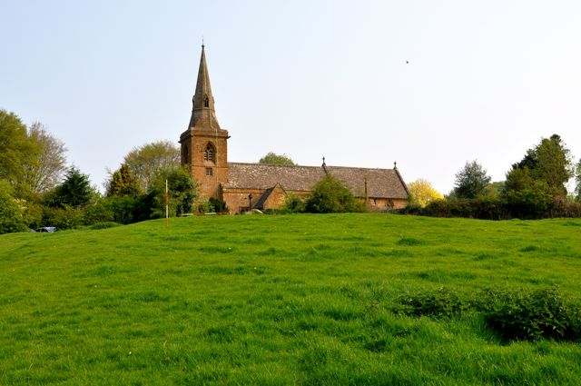
Following a detailed survey of the earthwork remains in the field south of St. Botolph's Church we are now in a position to publish some of the plans and profiles and make some provisional suggestions as to what these earthworks tell us about settlement in the medieval period and beyond.
Click on the site map for
detailed plans of individual groups of earthworks
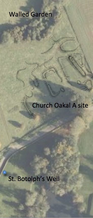
Church Oakal A Site
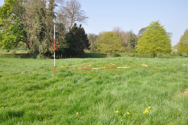
The valley bottom is occupied by a complex series of earthworks in varying states of preservation. On the ground the most prominent feature is an earth bank running roughly east - west parallel to and a little upslope from the valley bottom. The bank merges into the valley side at its east end and is cut towards this end by two deep channels. The bank has been 'pushed over' towards its west end and terminates above a marshy area a few metres short of the Banbury road. This was originally interpreted as a dam behind which waters could be penned to run one or more water mills sited next to the channels mentioned previously. More detailed examination makes this conclusion less certain but its interpretation is made difficult because of the destruction by ploughing of further associated earthworks in the field to the south (personal communication). Some stone work is eroding out from the southern margin of the bank towards its western end which may represent a revetment of some kind or possibly a wall foundation. The valley bottom itself is occupied by a rectangular platform with a raised rim and surrounded by what appears to be a shallow moat. Beyond this to the north west the moat broadens out into a low level area which may mark the site of an attached fishpond. Other low banks and terraces suggest the possibility of ancillary structures to what appears to be a typical medieval homestead site possibly the remains of a medieval manor? The area is drained by a series of stone lined drains which we will consider in detail in the report of the bridge.
Church Oakal A:
Cuts through bank view looking W Rectangular platform and moat looking NW SE corner of moated platform from E
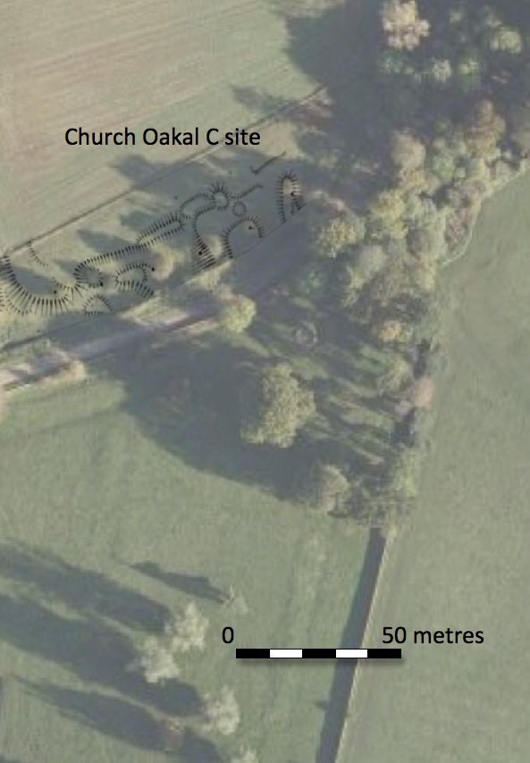
Church Oakal C Site
The outline of the field in the 1772 estate map included this projection to the south. This boundary is still respected today although the fencing is obviously modern. The irregular nature of these earthworks suggests quarrying and it may well be that the land was set aside from the adjacent arable either because of its continuing use as a quarry or perhaps more likely because of the difficulty of cultivating such broken ground. However, detailed survey of the remains indicates a degree of regularity to some parts of the site which may indicate other occupation.
Future Work
We have begun a detailed photographic record of these earthworks but are now waiting for the die back of the vegetation and slanting winter light to complete this. We intend to undertake some coring of the deposits in the channels, moat and fishpond areas. Although our current brief does not include excavation we will be developing proposals for some very small scale evaluations to ascertain the character, survival and latest date of a number of significant features.
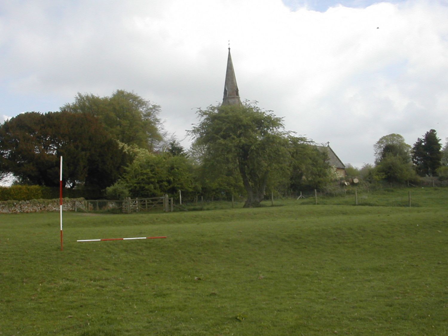
Church
Oakal is a field named in the 1772 estate survey. It lies to the south
of St. Botolph's Church and to the east
of the current hall and park being separated from them by the Banbury
road. The shape of the field in the eighteenth century was rectangular,
aligned east - west and roughly 400 yards (370 metres) by 180 yards
(160 metres).
There was a narrow projection to the south which overall created an 'L'
shaped plan - more of this later. Topographically the field
occupies the north side and bottom of a shallow valley which lies
between two hills; Oakal Hill (Oak Hill Hill!) to the south and Church
Hill to the north. The water discharges to the west currently through a
stone lined drain which passes below the foot way which passes
underneath the Banbury road by means of a well made ironstone
tunnel/bridge.
Some of the the field today is occupied by the remains of the early
nineteenth century walled kitchen garden. Most of the earthworks are along the
western margin of the field and can be clearly seen from the road, in
addition there is access to the land via a footpath which neatly runs
through the middle of all three sites.
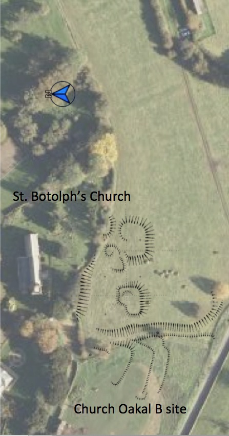
Church Oakal B Site.
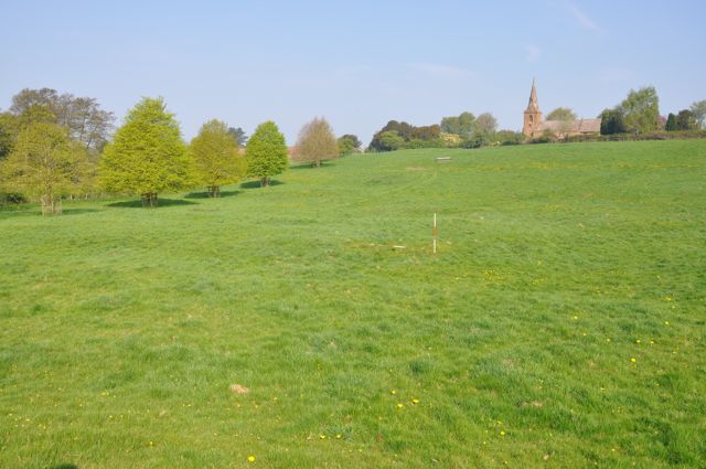
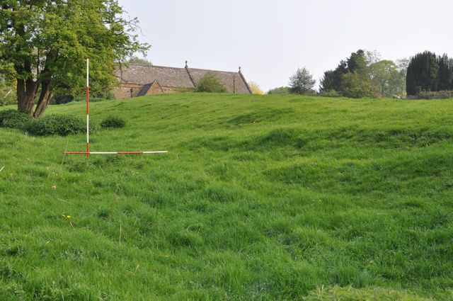
From the outset the empty field adjacent to the hilltop church has always seemed anomalous and it came as no surprise when inspecting the site to find a series of well defined platforms which seem to indicate the presence of buildings. Four distinct platforms have been planned which could tentatively be identified as a farmstead with the main house on the crest of the hill on the western side of the complex, a larger building, possibly a barn to the east and smaller ancillary buildings to the north. Alternatively we could be looking at up to four individual dwellings. This area is bounded on the north by the wall of the churchyard which acts as a revetment to the higher ground around the church. The wall appears to cut at least one platform suggesting the beginnings of a sequence. The conventional explanation for the removal of these buildings would be to improve the view of the church from Farnborough Hall but until we can examine and date the abandonment of these structures this remains speculation.To the west of the platform complex is a clearly defined holloway which runs down the hillside from a point to the east of the church to the Banbury road where if curves round to match the existing roadway. On the other side of the park wall is St. Botolph's Well and it seems likely that the route linked the church to the holy well and perhaps additionally this part of the settlement to the road to Banbury. East of the holloway in a separate paddock are three low terraces with broad leveled tops and steep, low, well defined slopes. These are probably garden terraces and may relate to a later phase of occupation on the site. The middle terrace has earthwork traces of a possible set of steps or a ramp connecting it with the lower terrace. These earthworks could be associated with Mount Farm to the east or the rectory to the north.
Church Oakal B:
East most building platform looking N Holloway looking N Garden terracing, middle and upper, looking NW
Church Oakal B Site.
From the outset the empty field adjacent to the hilltop church has always seemed anomalous and it came as no surprise when inspecting the site to find a series of well defined platforms which seem to indicate the presence of buildings. Four distinct platforms have been planned which could tentatively be identified as a farmstead with the main house on the crest of the hill on the western side of the complex, a larger building, possibly a barn to the east and smaller ancillary buildings to the north. Alternatively we could be looking at up to four individual dwellings. This area is bounded on the north by the wall of the churchyard which acts as a revetment to the higher ground around the church. The wall appears to cut at least one platform suggesting the beginnings of a sequence. The conventional explanation for the removal of these buildings would be to improve the view of the church from Farnborough Hall but until we can examine and date the abandonment of these structures this remains speculation.To the west of the platform complex is a clearly defined holloway which runs down the hillside from a point to the east of the church to the Banbury road where if curves round to match the existing roadway. On the other side of the park wall is St. Botolph's Well and it seems likely that the route linked the church to the holy well and perhaps additionally this part of the settlement to the road to Banbury. East of the holloway in a separate paddock are three low terraces with broad leveled tops and steep, low, well defined slopes. These are probably garden terraces and may relate to a later phase of occupation on the site. The middle terrace has earthwork traces of a possible set of steps or a ramp connecting it with the lower terrace. These earthworks could be associated with Mount Farm to the east or the rectory to the north.
Church Oakal B:
East most building platform looking N Holloway looking N Garden terracing, middle and upper, looking NW
Church Oakal A Site
The valley bottom is occupied by a complex series of earthworks in varying states of preservation. On the ground the most prominent feature is an earth bank running roughly east - west parallel to and a little upslope from the valley bottom. The bank merges into the valley side at its east end and is cut towards this end by two deep channels. The bank has been 'pushed over' towards its west end and terminates above a marshy area a few metres short of the Banbury road. This was originally interpreted as a dam behind which waters could be penned to run one or more water mills sited next to the channels mentioned previously. More detailed examination makes this conclusion less certain but its interpretation is made difficult because of the destruction by ploughing of further associated earthworks in the field to the south (personal communication). Some stone work is eroding out from the southern margin of the bank towards its western end which may represent a revetment of some kind or possibly a wall foundation. The valley bottom itself is occupied by a rectangular platform with a raised rim and surrounded by what appears to be a shallow moat. Beyond this to the north west the moat broadens out into a low level area which may mark the site of an attached fishpond. Other low banks and terraces suggest the possibility of ancillary structures to what appears to be a typical medieval homestead site possibly the remains of a medieval manor? The area is drained by a series of stone lined drains which we will consider in detail in the report of the bridge.
Church Oakal A:
Cuts through bank view looking W Rectangular platform and moat looking NW SE corner of moated platform from E
Church Oakal C Site
The outline of the field in the 1772 estate map included this projection to the south. This boundary is still respected today although the fencing is obviously modern. The irregular nature of these earthworks suggests quarrying and it may well be that the land was set aside from the adjacent arable either because of its continuing use as a quarry or perhaps more likely because of the difficulty of cultivating such broken ground. However, detailed survey of the remains indicates a degree of regularity to some parts of the site which may indicate other occupation.
Future Work
We have begun a detailed photographic record of these earthworks but are now waiting for the die back of the vegetation and slanting winter light to complete this. We intend to undertake some coring of the deposits in the channels, moat and fishpond areas. Although our current brief does not include excavation we will be developing proposals for some very small scale evaluations to ascertain the character, survival and latest date of a number of significant features.
July 2011